
Ontario Highway 6
| ||||
|---|---|---|---|---|
| Location | ||||
| Country | Little Current, Espanola | |||
| Highway system | ||||
| ||||
King's Highway 6, commonly referred to as Highway 6, is a
Highway 6 was one of several routes established when Ontario first introduced a highway network on February 26, 1920, following several pioneer wagon trails. The original designation, not numbered until 1925, connected Port Dover with
Highway 6 is one of two highways in Ontario (the other being
Route description
Port Dover to Hamilton
Highway 6 begins at Saint Patrick Street in the community of Port Dover, and stretches northward as a two-lane, undivided highway. The road travels into Haldimand County, through communities such as Jarvis and Hagersville, and the traffic flow increases. At Caledonia, the road bypasses the former Highway 6 section (Argyle Street) that passes the town centre of Caledonia and is routed outside the urban area Caledonia. This Caledonia Bypass was opened in 1983, and is a two-lane undivided freeway. The bypass terminates at Green's Road on the north side of Caledonia and Highway 6 proceeds eastbound on Green's Road for approximately 500 metres to Argyle St. North. Highway 6 then turns north on a four-lane undivided alignment for 5 km. Much of the old alignment north to near Rymal Road remains provincially maintained as unsigned Highway 7273.
In Hamilton, Highway 6 now uses a new alignment from Highway 403 to south of the
Hamilton to Guelph
The section of Highway 6 between
North of Clappison's Corners, most of the route is four lanes for general traffic, plus one centre lane for left turns, allowing for high travel speeds as the typical flow varies between 100 and 120 km/h (62 and 75 mph). However the section in
North of Morriston when Brock Road meets Highway 401 at a Parclo A2 interchange (the exits from Highway 401 are displayed as "Highway 6 South"), while through traffic on Brock Road continues as Wellington Road 46, the current Highway 6 designation is instead multiplexed with Highway 401 west of that junction. Although Wellington Road 46 (the previous alignment of Highway 6 prior to the opening of the Hanlon) does provide a more direct route to Guelph, the combination of Highway 401 and the Hanlon Expressway serves as an express bypass. The section where Highway 6 is concurrent with the Highway 401 freeway has the highest AADT (Annual Average Daily Traffic), at 85,000 automobiles per day in 2002. The Highway 6 routing splits from Highway 401 at a trumpet interchange with the Hanlon Expressway (the on-ramps from Highway 401 are signed as "Highway 6 North"). [4][5]
In Guelph, the road travels along the full length of the Hanlon Expressway (also known as the Hanlon Parkway), a four lane divided highway with mostly signalized level intersections and a couple grade-separated interchanges. The Ministry of Transportation is presently investigating the possibility of upgrading it to 400-series freeway standards by removing the remaining intersections. For 4 km Highway 6 is concurrent with Highway 7, from the Wellington Street interchange north to where the Hanlon Expressway ends at Woodlawn Road. At Woodlawn, Highway 7 turns west onto Woodlawn Road, while Highway 6 turns east onto Woodlawn Road. Following Woodlawn, Highway 6 then turns north onto Woolwich Street, leaving the city of Guelph.[4][5]
Guelph to Owen Sound
As Highway 6 leaves Guelph and heads northwards through Wellington County, it narrows to two lanes and passes through farmland.[citation needed] The route meanders northward for 17 kilometres (11 mi) before entering Fergus, where it meets County Road 18 and County Road 19. North of Fergus, Highway 6 winds northwest for another 17 kilometres into Arthur meeting County Road 109 (former Highway 9) just south of the town. After exiting Arthur, the route continues northwest for 22 kilometres (14 mi) before entering Mount Forest and meeting an intersection with Highway 89.[4][5]
The route enters
Owen Sound to Tobermory
At
South Baymouth to McKerrow


The Chi-Cheemaun ferry docks at South Baymouth, and Highway 6 continues as a two-lane highway. Highway 6 is both the main means of connection between
Highway 6 continues north, passing through communities such as
After crossing the North Channel, Highway 6 climbs through the
History
Wagon trails
Prior to the establishment of Ontario's provincial highway network in 1920, the route that would become Highway 6 was composed of several early wagon trails created during the early settlement of what was then known as
In 1837, Charles Rankin was hired by the Canada Company to survey a line between Guelph and a new town site on the southern shore of Georgian Bay known as Sydenham. The Canada Company was formed by several British investors to purchase, open, and settle the Huron Tract, a vast wilderness stretching from Guelph north to Georgian Bay and west to Lake Huron. Rankin's line crossed too many natural obstacles, a result of the tendency to build roads that were straight rather than following the natural topography. Consequently, a new line was surveyed in 1840 by the company's own surveyor, John McDonald, and construction along this new route began. Around the same time, the Van Norman Company constructed a plank road between Port Dover and Hamilton known as both the Hamilton Plank Road and the Dover Road.[11][12] By 1848, the 119 km (74 mi) Garafraxa Road between Guelph and Sydenham was completed.[13][14]
The remaining section between Hamilton and Guelph, known as the Brock Road, was constructed between 1848 and 1850 over the Guelph and Dundas wagon road.[15] The wagon road, merely a trail through the forest, was cleared by the Canada Company in the 1820s to connect the fledgling town of Guelph with the established harbour at Hamilton, thus encouraging settlers to venture inland.[16]
Further north, the Southwest Diagonal was surveyed in 1842 by Charles Rankin to provide a short route from the Sydenham townsite to the Hepworth townsite. This route passed through a large swamp and as a result remained an unimproved one lane trail into the 1920s. The Centre Road, the spine of the Bruce Peninsula, was built by the Department of Northern Development in the early 1920s, providing access to communities north of Wiarton. The route followed a telegraph line between Lion's Head and Tobermory and opened up a large area previously accessible only by water.
The latter two would not be incorporated into the original route of Highway 6.
Provincial highway

When Ontario's Department of Public Highways first established a network of provincial highways on February 26, 1920 to be eligible for federal funding, it included the Hamilton and Dover Plank Road, the Brock Road and the Garafraxa Road.[17] These roads were assumed from the various counties that held jurisdiction over them – Norfolk, Haldimand, Wentworth, Wellington and Grey – throughout June, July and August 1920.[2]
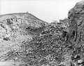
Within Wentworth County, the construction of the Clappison Cut through the Niagara Escarpment was underway by 1921, with the aim of bypassing the winding old route that is known today as Old Guelph Road.[18] The new route, which travelled straight along the boundary between East and West Flamboro, was assumed on January 12, 1921.[19] The province and the City of Hamilton also constructed several new bridges across Cootes Paradise to create a new northwest entrance into Hamilton. The new entrance, connecting the Toronto–Hamilton Highway (later Highway 2) with the incomplete route up the escarpment to Clappison's Corners, was ceremonially opened by the Minister of Public Works and Highways, Frank Campbell Biggs, on August 23, 1922.[20] The Clappison Cut was completed and paved in 1924.[21]
- Clappison Cut construction, 1920–1924
-
-
 A set of rails were installed to remove excavated earth and rock
 -

-
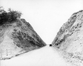 Completed work


Highway 5 and Highway 6 travelled concurrently from Highway 8 (Main Street) in downtown Hamilton to Clappison's Corners when route numbers were assigned in 1925.[22] Highway 5 was 127.4 kilometres (79.2 mi) long at this time. This situation was short lived however, as Highway 5 was redirected west from Clappison's Corners to Peters Corners to meet Highway 8 on May 25, 1927. Highway 6, in turn, assumed the route of Highway 5 south to Jarvis.[23] The route was extended further west in 1930, when the newly-renamed Department of Highways (DHO) assumed the road from Highway 8 at Peters Corners to Highway 24 west of
South of Hamilton, the road to Jarvis was numbered as Highway 5 when route numbers were assigned in the middle of 1925. Highway 5 and Highway 6 travelled concurrently from downtown Hamilton to Clappison's Corners.[29] However, on May 25, 1927, several route numbers were revised, including Highways 5 and 6. Highway 5 was redirected west from Clappison's Corners to Peter's Corners to meet Highway 8. Highway 6, in turn, assumed the route of Highway 5 south to Jarvis. Exactly two weeks prior, on May 11, the Department of Public Highways had assumed the road between Jarvis and Port Dover; this also became a section of Highway 6, establishing its southern terminus for the next seven decades.[30]
North of the escarpment to Highway 401, Highway 6 follows the same route that it did in 1920, the Brock Road. North of Highway 401, which didn't exist before the 1950s, the route continued through Guelph along what is now Gordon Street, Norfolk Street and Woolwich Street. This section has since been replaced by the Hanlon Expressway, built throughout the 1970s.
North of Guelph to Owen Sound, the route also follows the same route as it did in 1920, with some small deviations. The section from Fergus north towards Arthur followed the route was of the old Fergus and Arthur Road Company. A "cheap attempt" at paving had been made in the 1920s. The section was straightened, widened and paved with asphalt-based "penetration pavement" in 1930.[31]
On April 1, 1937, the Department of Northern Development was absorbed into the Department of Highways, which subsequently took over many development roads as provincial highways. Most of the northern sections of Highway 6 were included amongst these. Highway 68 was designated from Little Current north to Espanola on August 11, 1937. Two weeks later, on August 25, Highway 6 was designated in Bruce County, from Wiarton north to Tobermory. The section within Grey County was designated several months later on November 3.[32] The lone remaining section of what would eventually become today's Highway 6, across Manitoulin Island, was not designated until December 7, 1955.[33] The entirety of Highway 68 eventually became part of Highway 6 in the early to mid- 1980.[34]

Expressways and bypasses
- Longwoods Road extension
Under the leadership of
Mount Hope Bypass
Due to the narrow spacing of buildings in the village of
Hanlon Expressway

With the rapid suburban expansion of Guelph in the 1950s and 1960s, a revised transportation plan was conceived to handle the increasing traffic load. The Guelph Area Transportation Study was completed in 1967, and recommended a new controlled-access highway to allow through-traffic on Highway 6 to bypass the city. Route planning, engineering and design began on October 2, 1967 and was subsequently completed in 1969.[38] Construction began between Waterloo Avenue and Stone Road in 1970;[39] this section opened on June 28, 1972.[40] The next section, from Stone Road to Clair Road, opened in October 1973.[39] Work on the northern section from Waterloo Avenue to Woodlawn Road began in August 1974.[41] It and the final section south to Highway 401 were opened on November 7, 1975.[42]
Initially, the 15.4-kilometre-long (9.6 mi) road featured no interchanges. However, the MTO has long-intended to upgrade the route to a freeway.
Caledonia Bypass
In 1976, a corridor study was completed on Highway 6 between Port Dover and Hamilton, indicating a need for a bypass of Caledonia due to the aging multi-span bridge over the Grand River, to improve capacity to the developing areas of Nanticoke near Lake Erie,[48] and to reduce the high-volume of truck traffic passing through the town.[49] Construction began in late 1979 on structures to cross the Grand River and to carry rail lines and three crossroads over the bypass.[50] The bypass was completed in the fall of 1983.[49] The old route through Caledonia is now known as Argyle Street.[5]
Downloading and changes since


On April 1, 1997, Highway 6 was decommissioned south of Hepworth to Highway 21. The entire length of Highway 70 was subsequently renumbered Highway 6 to rectify the discontinuity. On the same day, the section between the southern terminus at former Highway 24 to the west side of the
A new 9.7-kilometre-long (6.0 mi) segment of Highway 6 was opened to the southwest of John C. Munro Hamilton International Airport in 2004.[37] This building of this route had been planned since the construction of the Caledonia Bypass in 1983. However, concrete plans were not announced until January 1993. However, it had already drawn criticism due to an old-growth forest located in the path of the route. The planned highway would cost a projected $100 million.[53] However, these plans never came to fruition, and by 1997 a new, shorter route was in the planning stages.[54] Construction of the $33 million route was announced on May 26, 2000 by Transportation Minister David Turnbull,[55] and began in July 2003.[56]
The new route was opened on November 26, 2004.[57] The section through Hamilton at the time followed Upper James Street through the Claremont Access onto the one-way pairings of Wellington Street and Victoria Avenue then Main Street and King Street. It turned north on Dundurn Street and crossed Cootes Paradise via York Boulevard before turning onto Plains Road and meeting the current route at the now-closed intersection.[58] The responsibility for this routing was subsequently transferred to the City of Hamilton.[37]
In early 2002, it was announced that the section of Highway 6 north of Hamilton, from Highway 403 north to beyond Highway 5, would be widened to a five lane freeway, with the northbound carriageway featuring an additional truck-climbing lane.[59] This work began in 2006, widening and dividing the highway up the Clappison Cut. The York Road interchange opened on May 23, 2009, following completion of this work. The Plains Road/Northcliffe Avenue intersection was closed the night before and a new section of Plains Road opened on the same day as the interchange.[60] The project to upgrade this segment of Highway 6 was $34 million.[61]

Future
Three sections of Highway 6 are undergoing planning as of 2022.
- Highway 6 South (from Upper James Street south of Mt. Hope to Highway 403) is proposed four-laning around John C. Munro Airport that is undergoing preliminary design as of February 17, 2022[62]
- The Morriston Bypass (from Maddaugh Road, south of Puslinch, to Highway 401 west of Morriston) is a proposed new two or four lane alignment of Highway 6 currently in early works construction.[63]
- The Hanlon Expressway Mid-Block Interchange project will result in a new interchange between Wellington County Road 34 and Maltby Road, as well as the removal of the existing intersections between the Hanlon Expressway and those two roads. A design–build contract for this work was awarded in February 2022.[64][65]
Major intersections
The following table lists the major junctions along Highway 6, as noted by the Ministry of Transportation of Ontario.[1]
| Division | Location | km[1] | mi | Exit | Destinations | Notes |
|---|---|---|---|---|---|---|
County Highway 24 – Simcoe | Former southern terminus; formerly Highway 24 | |||||
County Road 5 north (Chapman Street) | ||||||
| 0.0 | 0.0 | County Highway 6 ends | Current southern terminus; portion west of Port Dover downloaded in the late 1990s | |||
County Road 3 east(St. Johns Road East) | ||||||
| Haldimand | 10.3 | 6.4 | ||||
| Jarvis | 13.4 | 8.3 | Jarvis Connecting Link | |||
| 15.0 | 9.3 | |||||
| 16.3 | 10.1 | |||||
| 21.1 | 13.1 | |||||
| Hagersville | 23.5 | 14.6 | Hagersville Connecting Link | |||
| 23.5 | 14.6 | |||||
| 31.0 | 19.3 | |||||
| Caledonia | 35.4 | 22.0 | Argyle Street South | Beginning of Caledonia Bypass; controlled-access Super 2 | ||
| 38.7– 38.9 | 24.0– 24.2 | Bridge over the Grand River | ||||
Highway 54 | ||||||
| 40.8 | 25.4 | Greens Road | To County Highway 54 | |||
| 41.9 | 26.0 | Argyle Street North | End of Caledonia Bypass | |||
City Road 65 | ||||||
| 50.0 | 31.1 | Highway 7274 (Airport Road Connection) | To John C. Munro Hamilton International Airport | |||
| 54.8 | 34.1 | Book Road | ||||
| Freeway begins | ||||||
| 56.2 | 34.9 | — | Garner Road | Southbound exit and northbound entrance; no exit from Highway 403 east; former Highway 53 | ||
| 57.5 | 35.7 | 61 | Southern end of Highway 403 concurrency; exit numbers follow Highway 403 | |||
| 60.4 | 37.5 | 64 | Lincoln M. Alexander Parkway Rousseaux Street | |||
| 65.2 | 40.5 | 69 | Aberdeen Avenue | |||
| 66.6 | 41.4 | 70 | City Road 8 (Main Street) | Former Highway 2 / Highway 8; entrance ramps from nearby King Street | ||
| 68.9 | 42.8 | 73 | York Boulevard | Westbound exit and eastbound exit; formerly Highway 6 south / Highway 2 | ||
Toronto, Niagara | Northern end of Highway 403 concurrency | |||||
| 71.7 | 44.6 | — | York Road | |||
| Freeway ends | ||||||
City Road 5 east )(Dundas Street | Clappison's Corners | |||||
| 77.2 | 48.0 | Millgrove Sideroad | ||||
| 83.3 | 51.8 | Carlisle Road | ||||
| 86.4 | 53.7 | Highway 97 | ||||
| Wellington | Puslinch | 90.1 | 56.0 | |||
| 91.0 | 56.5 | 299 | Toronto | Beginning of Highway 401 concurrency; exit numbers follow Highway 401 | ||
| 95.4 | 59.3 | 295 | End of Highway 401 concurrency | |||
| 96.5 | 60.0 | Concession Road 4 Maltby Road West | ||||
| Guelph | 100.5 | 62.4 | Clair Road West Phelan Drive | Closed with opening of Laird Road Interchange[45] | ||
| 101.1 | 62.8 | Laird Road | Grade-separated as of November 29, 2013[45] | |||
| 103.6 | 64.4 | Downey Road (west) Kortright Road West (east) | ||||
| 104.6 | 65.0 | Stone Road West | ||||
| 105.5 | 65.6 | College Avenue West | ||||
| 107.1 | 66.5 | Brampton | Beginning of Highway 7 concurrency; grade-separated as of July 2001;[43] formerly Highway 24 | |||
| 108.1 | 67.2 | Paisley Road | ||||
| 108.9 | 67.7 | Willow Road | ||||
| 109.8 | 68.2 | Speedvale Avenue West | ||||
| 110.8 | 68.8 | End of Highway 7 concurrency; Highway 6 follows Woodlawn Road West; beginning of Guelph Connecting Link | ||||
| 113.1 | 70.3 | Woolwich Street / Woodlawn Road East | Former route of Highway 6 south | |||
| 113.4 | 70.5 | End of Guelph Connecting Link | ||||
| Wellington | Guelph/Eramosa | 114.3 | 71.0 | |||
| 115.4 | 71.7 | County Road 7 north (Elora Road) – Elora | ||||
| 117.3 | 72.9 | |||||
| 118.3 | 73.5 | |||||
| Guelph/Eramosa – Centre Wellington boundary | 120.8 | 75.1 | ||||
Centre Wellington | 128.8 | 80.0 | Fergus Connecting Link | |||
| 129.8 | 80.7 | |||||
| 130.2 | 80.9 | |||||
| Centre Wellington – Mapleton boundary | 138.8 | 86.2 | ||||
County Road 109 – Orangeville, Harriston | Former Highway 9 | |||||
| 149.1 | 92.6 | Arthur Connecting Link | ||||
| 172.5 | 107.2 | Mount Forest Connecting Link | ||||
| Wellington – Grey boundary | Wellington North – West Grey–Southgate boundary | 175.1 | 108.8 | |||
West Grey – Southgate boundary | 177.0 | 110.0 | ||||
| 182.4 | 113.3 | County Road 9 west – Ayton | ||||
| 186.2 | 115.7 | County Road 9 east – Dundalk | ||||
West Grey | 195.3 | 121.4 | Douglas Street | Beginning of Durham Connecting Link | ||
| 196.5 | 122.1 | County Road 4 (Lambton Street) | Former Highway 4 | |||
| 197.2 | 122.5 | Old alignment of Highway 4; end of Durham Connecting Link | ||||
| 206.5 | 128.3 | |||||
West Grey – Chatsworth boundary | 212.0 | 131.7 | Dornoch | |||
| Chatsworth | 219.4 | 136.3 | ||||
| 227.0 | 141.1 | Beginning of Chatsworth Connecting Link | ||||
| 228.6 | 142.0 | Brampton | Beginning of Highway 10 concurrency; end of Chatsworth Connecting Link | |||
| Chatsworth–Georgian Bluffs–Meaford boundary | 230.8 | 143.4 | ||||
| Georgian Bluffs – Meaford boundary | 238.5 | 148.2 | ||||
| Owen Sound | 240.2 | 149.3 | Superior Street / 4th Street East | Beginning of Owen Sound Connecting Link | ||
| 241.5 | 150.1 | Barrie | Highway 10 northern terminus; end of Highway 10 concurrency; Highway 21 northern terminus; beginning of Highway 21 concurrency; Highway 26 western terminus | |||
| 242.9 | 150.9 | |||||
| 244.1 | 151.7 | End of Owen Sound Connecting Link | ||||
Georgian Bluffs | 246.8 | 153.4 | End of Highway 21 concurrency; former Highway 70 north | |||
| 248.0 | 154.1 | |||||
| 257.0 | 159.7 | Copperkettle | ||||
Hepworth ; former Highway 70 south | ||||||
| Bruce – Grey boundary | South Bruce Peninsula – Georgian Bluffs boundary | 270.6 | 168.1 | |||
Wiarton Connecting Link | ||||||
| 274.5 | 170.6 | Oliphant | ||||
| 276.7 | 171.9 | Colpoy's Bay | ||||
Northern Bruce Peninsula | 303.6 | 188.6 | Ferndale | |||
| 356.3 | 221.4 | Big Tub Road / Front Street | Tobermory Ferry Docks | |||
| Georgian Bay | ||||||
South Baymouth Ferry Docks; the entire route from this location northerly to McKerrow was designated as Highway 68 prior to 1980. | ||||||
| 369.2 | 229.4 | Tehkummah | ||||
Little Current | ||||||
| 421.2 | 261.7 | Little Current Swing Bridge over the North Channel | ||||
| Sudbury | Espanola | 465.8 | 289.4 | Foster Drive | Espanola Connecting Link | |
| 469.7 | 291.9 | Tudhope Street | ||||
McKerrow | ||||||
1.000 mi = 1.609 km; 1.000 km = 0.621 mi
| ||||||
References
- ^ a b c d e Ministry of Transportation of Ontario (2010). "Annual Average Daily Traffic (AADT) counts". Archived from the original on July 6, 2011. Retrieved January 23, 2014.
- ^ a b "Report on Provincial Highways". Annual Report (Report). Department of Highways. January 30, 1921. pp. 40–45.
- ^ Road Atlas: Canada, United States, and Mexico (Map) (2008 ed.). Peter Heiler Ltd. pp. 17, 19. §§ B6–G7, G8–K8, L9, M10–R11.
- ^ ISBN 1-55198-226-9.
- ^ a b c d e f g h i j k Google (January 23, 2014). "Highway 6: length and route" (Map). Google Maps. Google. Retrieved January 23, 2014.
- ^ "Owen Sound's scenic cruises include sunset dining and stargazer's delights". Owen Sound Transportation Company. Archived from the original on August 28, 2017. Retrieved August 27, 2017.
- ^ "Complete 2017 Chi-Cheemaun Sailing Schedule" (PDF). Owen Sound Transportation Company. Archived from the original (PDF) on September 8, 2017. Retrieved August 27, 2017.
- ^ Aelick, Lyndsay (March 30, 2021). "Preferred option to replace aging Manitoulin Island swing bridge is a new, two-lane structure". CTV Northern Ontario. Retrieved May 4, 2021.
- ^ Annual Report. 1919. Retrieved December 9, 2014 – via Google Books.
- ^ "Full text of "The Bruce Beckons The Story Of Lake Huron S Great Peninsula"". Retrieved December 9, 2014.
- ^ Ontario Historical Society (1919). Ontario History. Kraus Reprint. p. 95. Retrieved October 18, 2010.
- ^ Report of the Commissioners ... laid before the Legislative assembly, 12th ... 1847. Retrieved December 9, 2014 – via Google Books.
- .
- .
- .
- .
Guelph Dundas Wagon.
- ISBN 0-7743-9388-2.
- ^ "Toronto–Hamilton Highway (via Dundas St.)". Annual Report (Report) (1921 ed.). Department of Public Highways. April 26, 1923. p. 51. Retrieved April 13, 2022 – via Internet Archive.
- ^ "Provincial Highways Assumed in 1921". Annual Report (Report) (1921 ed.). Department of Public Highways. April 26, 1923. p. 23. Retrieved April 13, 2022 – via Internet Archive.
- ProQuest 1356404596(subscription required).
- ^ Annual Report (Report) (1923, 1924 and 1925 ed.). Department of Public Highways. April 26, 1926. p. 68. Retrieved April 18, 2022 – via Internet Archive.
- ^ "Provincial Highways Now Being Numbered". The Canadian Engineer. 49 (8). Monetary Times Print: 246. August 25, 1925.
Numbering of the various provincial highways in Ontario has been commenced by the Department of Public Highways. Resident engineers are now receiving metal numbers to be placed on poles along the provincial highways. These numbers will also be placed on poles throughout cities, towns and villages, and motorists should then have no trouble in finding their way in and out of urban municipalities. Road designations from "2" to "17" have already been allotted... Road No. 5 — Toronto to Jarvis, via Dundas Highway and Hamilton. Route No. 6 — Hamilton to Owen Sound.
- ^ "Appendix 6: Schedule of Assumptions and Reversions of Sections of the Provincial Highway System for the Years 1926 and 1927". Annual Report (Report). Department of Public Highways. March 31, 1928. pp. 59–60. Retrieved April 18, 2022 – via Internet Archive.
- ^ "Appendix 5: Schedule of Assumptions and Reversions of Sections of the King's Highway System for the Years 1930 and 1931". Annual Report (Report). Department of Highways. October 24, 1932. p. 76. Retrieved April 19, 2022 – via Internet Archive.
- ^ Ontario Road Map (Map) (1931–32 ed.). Department of Highways of Ontario. Retrieved April 19, 2022 – via Archives of Ontario.
- ^ Google (April 19, 2022). "Highway 5 route in 1931" (Map). Google Maps. Google. Retrieved April 19, 2022.
- ISBN 978-0-9734438-1-3.
- ^ Barclay, D. (1927). Ontario Road Map (Map). Ontario Department of Public Highways. § F5.
- ^ "Provincial Highways Now Being Numbered". The Canadian Engineer. 49 (8). Monetary Times Print: 246. August 25, 1925.
Numbering of the various provincial highways in Ontario has been commenced by the Department of Public Highways. Resident engineers are now receiving metal numbers to be placed on poles along the provincial highways. These numbers will also be placed on poles throughout cities, towns and villages, and motorists should then have no trouble in finding their way in and out of urban municipalities. Road designations from "2" to "17" have already been allotted... Road No. 5 — Toronto to Jarvis, via Dundas Highway and Hamilton. Route No. 6 — Hamilton to Owen Sound.
- ^ "Appendix 6: Schedule of Assumptions and Reversions of Sections". Annual Report (Report). Department of Public Highways. March 31, 1928. p. 60. Retrieved April 10, 2022 – via Internet Archive.
- ^ Thorning Stephen. "Highway departments undertook paving despite 1930 Depression". The Wellington Advertiser. Archived from the original on September 15, 2014. Retrieved September 14, 2014.
- ^ "Appendix 3: Schedule of Assumptions and Reversions of Sections". Annual Report (Report). Department of Highways. March 31, 1938. p. 80.
- ^ "Appendix 3: Schedule of Assumptions of Sections". Annual Report (Report). Department of Highways. March 31, 1956. p. 204.
- ^ Public and Safety Information Branch (December 13, 1979). "Highway 68 on Manitoulin Island to be Renumbered as Highway 6" (Press release). Ministry of Transportation and Communications.
- ^ a b Annual Report (Report). Department of Highways. March 31, 1958. p. 238.
- ^ Google (January 22, 2014). "Aerial view of Mount Hope" (Map). Google Maps. Google. Retrieved January 22, 2014.
- ^ a b c De Almeida, Jacquie (November 27, 2004). "The road to development; New $40m stretch of Highway 6 brings business, jobs, passengers to airport". Hamilton Spectator. p. A4.
- ^ Functional Planning Study of the Hanlon Expressway (Report). Read Voorhees & Associates Limited. 1969. pp. 1–4.
- ^ a b c The Guelph Transportation Study Committee, The New Hanlon Technical Advisory Committee (June 1974). "History of the Hanlon Expressway". Protecting The Option For Future Interchanges And Grade Separations In The Hanlon Corridor City Of Guelph Report 10 of the Guelph Transportation Plan (Report). Marshall Macklin Monghan Limited. pp. 6–7. Archived from the original on December 19, 2013. Retrieved December 18, 2013.
- ^ "Felix Hanlon". Guelph Public Library. Archived from the original on December 14, 2013. Retrieved December 14, 2013.
- ^ Fear, Jonathan (August 15, 1974). "$230 million to be spent on roads this year: Passing lanes may become common on Ontario highways". The Globe and Mail. Toronto. p. 4.
- ^ "Photo Database – Guelph Mercury Fonds, records 131–133". Guelph Public Library. Archived from the original on December 16, 2013. Retrieved December 15, 2013.
- ^ a b c Kirsch, Vik (September 4, 2004). "Expressway still the plan for Hanlon". Guelph Mercury. p. A1.
- ^ Ministry of Transportation of Ontario (November 24, 1998). "Project To Complete Wellington Street Interchange Underway". Government of Ontario.
- ^ a b c d Cartwright, Peter; Philips, Rajan (November 29, 2013). "City and MTO Officially Open Hanlon Expressway/Laird Road Provincial Interchange". City of Guelph. Archived from the original on December 6, 2013. Retrieved December 14, 2013.
- ^ Rajan Philips (November 8, 2013). "New Interchange at the Hanlon Expressway and Laird Road to be opened". City of Guelph. Archived from the original on December 14, 2013. Retrieved December 14, 2013.
- ^ Cartwright, Peter (November 27, 2013). "Hanlon Expressway/Laird Road provincial interchange ceremonial opening". City of Guelph. Archived from the original on November 30, 2013. Retrieved January 8, 2013.
- ^ Route Projects Planning Office (1976). Highway 6, Nanticoke to Hamilton: joint use corridor study (Report). Ministry of Transportation and Communications.
- ^ a b Lee, Prokaska (January 29, 2001). "Caledonia bypass repairs still on; But province won't say when it'll fund intersection work". Hamilton Spectator. p. A11.
The bypass, which opened in the fall of 1983, was constructed to divert truck traffic away from the core of Caledonia...
- ^ Construction Program: King's and Secondary Highways. Ministry of Transportation and Communications. 1980–1981. p. XII.
- ^ Highway Transfers List (Report). Ministry of Transportation of Ontario. April 1, 1997. pp. 2, 4–5.
- ISSN 0825-5350.
- ^ Nolan, Dan (January 5, 1993). "$100 highway project could run into a snag Centuries-old forest on route". Hamilton Spectator. p. B1.
- ^ "Bridge over Highway 403 finally leads somewhere : Extension is still years from completion". Hamilton Spectator. November 27, 1997. p. A4.
- ^ Pettapiece, Mike (May 27, 2000). "Ontario gives $33m for Hwy. 6 link; Two-lane connection to airport will be ready in 2004". Hamilton Spectator. p. A1.
- ^ Nolan, Dan (November 24, 2004). "Highway to the Sky: Roadway lifts airport's future; Long- anticipated link between Highways 6 and 403 is expected to drive development at the airport and stimulate growth throughout the region". Hamilton Spectator. p. A1.
- ^ Ministry of Transportation (November 26, 2004). "Ontario Government Opens New Highway in Hamilton". Government of Ontario. Archived from the original on May 26, 2005. Retrieved January 24, 2014.
- ^ Geomatics Office (2003). Ontario Official Road Map (Map). Ministry of Transportation. Burlington and Hamilton inset.
- ^ Longbottom, Ross (February 5, 2002). "Clappison's Corners centrepiece of highway changes". Hamilton Spectator. p. A9.
- ^ Nolan, Dan (May 22, 2009). "Hwy. 6-York Road interchange to open Saturday". Hamilton Spectator. p. unknown. Archived from the original on February 1, 2014. Retrieved January 23, 2014.
- ^ Nolan, Daniel (May 12, 2009). "After 10 years, Hwy. 6, York interchange ready to open". Hamilton Spectator. p. A5.
- ^ "Ontario Moving Forward to Expand Highway 6 South" (Press release). Ministry of Transportation of Ontario. February 17, 2022. Retrieved April 1, 2022.
- ^ "Project Overview – Highways 6 & 401 Improvements". AECOM. Retrieved April 1, 2022.
- ^ Investing Our Highways highways6and401hamiltontoguelph.ca February 2022
- ^ "New Interchange Planned For Hanlon Expressway In Puslinch". Puslinch Today. November 26, 2021. Retrieved April 1, 2022.
External links
| |||||||||||||
| |||||||||||||
| |||||||||||||

