
Päijänne Water Tunnel

1. Asikkalanselkä
2. Kalliomäki water distribution station
3. Korpimäki water pump station
4. Artificial lake of Silvola
The Päijänne Water Tunnel (
The purpose of the tunnel is to provide
The tunnel starts at Asikkalanselkä in Lake Päijänne, the second-largest lake in Finland with an area of 1,080 square kilometres (420 sq mi). From there, the tunnel slopes slightly downhill allowing water to flow naturally with gravity. Water from the southern portion of Lake Päijänne is of good quality at the tunnel intake, and usually drinkable without processing. The tunnel ends at the 0.5 square kilometres (0.19 sq mi) Silvola reservoir in Vantaa. From the reservoir, water is pumped to water treatment plants in Pitkäkoski and Vanhakaupunki. Since the constant low temperature in the deep tunnel ensures high quality during transport, only minimal processing is required before use.[clarify]
The construction of the tunnel started in 1972 and was completed in 1982, at a cost of approximately €200 million (adjusted for inflation).
The tunnel has a cross section of 16 square metres (170 sq ft), wide enough for a truck to pass through, enabling a water flow of 10 cubic metres (350 cu ft) per second. It takes approximately nine days for the water to traverse the length of the tunnel.[6] At current water usage rates, treatment plants take water at a rate of about 3.1 cubic metres (110 cu ft) per second for drinking water processing. The tunnel can be used as an emergency water reserve during water supply disruption.[clarify]
Gallery
-
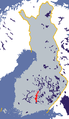 Location of Lake Päijänne in Finland.
 -
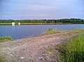
 Asikkalanselkä in Lake Päijänne, where the tunnel starts.
 -
 Silvola reservoir, where the tunnel ends.
 -
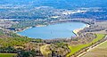 Aerial view of Silvola reservoir.


See also
References
- ^ "The water comes from Päijänne". Helsinki Region Environmental Services Authority HSY. Retrieved 24 February 2017.
- .
- ^ "Yleistä Päijänne-tunnelista" (in Finnish). Helsingin vesi. Retrieved 2008-10-12.
- .
- ISBN 952-11-2346-X.
- ^ "Tämä suljettu tekojärvi ja maailman toiseksi pisin tunneli varmistavat miljoonan ihmisen juomavedet" (in Finnish). Yle. 27 July 2020. Retrieved 27 July 2020.