
Petrich
Petrich
Петрич | |
|---|---|
 | |
|
UTC+3 (EEST) | |
| Postal Code | 2850 |
| Area code | (+359) 0745 |
| Website | Official website |
Petrich (
It is the seat of Petrich Municipality.
Petrich is located close to the borders with Greece and North Macedonia. The crossing into North Macedonia is known as
Petrich Peak on Livingston Island in the South Shetland Islands, Antarctica is named for Petrich.
History

Petrich was included in the territory of the
In October 1925 it was the site of a brief conflict between Greece and Bulgaria sometimes called the War of the Stray Dog.
Antiquity
Petrich is one of the old towns in the valley of the middle
Recent archaeological research and the location of the ancient city of
The Middle Ages
The Petrich region was annexed to the
During the period XII - XIV century Petrich became a strong fortress - part of the fortification system in southwestern Bulgaria. This is evidenced by the remains of the medieval fortress Gyaur Kalesi, around which the city originally arose. At least in the XIII - XIV century the city consists of two parts - a fortress, i.e. fortified city core and unfortified outer city, but with entrance-exit arteries guarded by towers.[3]
Petrich was first mentioned in written sources in the deeds of the Serbian magnates Jovan Dragaš and Konstantin Dragaš, who in 1376 - 1377 donated local properties to the Russian monastery "St. Pantaleimon" in Mount Athos. The town fell under Ottoman rule after 1395, when together with its surroundings it was included in the Kyustendil Sanjak as a center of independent Nahiyah.[4]
In the Ottoman Empire
During the years of
Revival struggles
During the
Geography
Climate
| Petrich (2004-2016) | ||||||||||||||||||||||||||||||||||||||||||||||||||||||||||||
|---|---|---|---|---|---|---|---|---|---|---|---|---|---|---|---|---|---|---|---|---|---|---|---|---|---|---|---|---|---|---|---|---|---|---|---|---|---|---|---|---|---|---|---|---|---|---|---|---|---|---|---|---|---|---|---|---|---|---|---|---|
| Climate chart (explanation) | ||||||||||||||||||||||||||||||||||||||||||||||||||||||||||||
| ||||||||||||||||||||||||||||||||||||||||||||||||||||||||||||
| ||||||||||||||||||||||||||||||||||||||||||||||||||||||||||||
Petrich has a mediterranean climate (Köppen Climate Classification Csa) with an average annual temperature of 15.6 °C (60 °F). The town experiences some continental influence, especially in winter, which is cool, but warm for Bulgarian standards.
Petrich is the sunniest city in Bulgaria slightly ahead of Sandanski with yearly sunshine hours exceeding 2,700 on average.
Summer is hot and sunny and it is the longest season in Petrich, lasting from May through September, even as late as October. The average summer temperature is around 25 °C. In July, the sunniest month, Petrich receives 373 hours of sunshine, making it one of the sunniest places in Continental Europe. Winter season, around two months, starts in late December and lasts until early February. Average winter temperature is one of the highest in the country with average around 5 °C. In December, the darkest month, there are 103 hours of sunshine, on average.
Climate table:
| Climate data for Petrich (2004-2016) | |||||||||||||
|---|---|---|---|---|---|---|---|---|---|---|---|---|---|
| Month | Jan | Feb | Mar | Apr | May | Jun | Jul | Aug | Sep | Oct | Nov | Dec | Year |
| Mean daily maximum °C (°F) | 9.5 (49.1) |
11.1 (52.0) |
15.6 (60.1) |
20.5 (68.9) |
26.0 (78.8) |
30.5 (86.9) |
33.5 (92.3) |
33.5 (92.3) |
28.1 (82.6) |
21.7 (71.1) |
15.5 (59.9) |
10.5 (50.9) |
21.2 (70.2) |
| Daily mean °C (°F) | 4.0 (39.2) |
5.5 (41.9) |
10.2 (50.4) |
14.8 (58.6) |
20.1 (68.2) |
24.0 (75.2) |
27.0 (80.6) |
27.0 (80.6) |
22.0 (71.6) |
16.1 (61.0) |
10.3 (50.5) |
5.1 (41.2) |
15.5 (59.9) |
| Mean daily minimum °C (°F) | 0.7 (33.3) |
1.6 (34.9) |
4.5 (40.1) |
9.1 (48.4) |
14.0 (57.2) |
17.5 (63.5) |
19.6 (67.3) |
19.6 (67.3) |
15.5 (59.9) |
10.9 (51.6) |
5.8 (42.4) |
2.6 (36.7) |
10.3 (50.5) |
| Average precipitation mm (inches) | 38 (1.5) |
38 (1.5) |
38 (1.5) |
38 (1.5) |
48 (1.9) |
39 (1.5) |
32 (1.3) |
28 (1.1) |
25 (1.0) |
38 (1.5) |
59 (2.3) |
50 (2.0) |
471 (18.5) |
| Mean monthly sunshine hours | 113 | 139 | 211 | 215 | 286 | 331 | 373 | 344 | 273 | 206 | 147 | 103 | 2,733 |
| Source: [7] | |||||||||||||
Economy
The town is an agricultural centre for fruit, vegetables and tobacco. It has three factories, making water level detectors, details for cranes and a furniture factory.
Broadcasting station
There is a 500 kW mediumwave broadcasting station working on 747 kHz. It uses as antenna a 205-metre-tall
International relations
- Twin towns - Sister cities
 Serres, Greece
Gallery
-
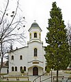 "St Bogoroditsa" Church
 -
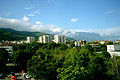
 Central Petrich
 -
 Petrich and Belasica
 -
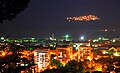 Petrich at night
 -
 Petrich and Pirin Mountains
 -
 The house of Vanga in Petrich


References
- ^ a b "Население по градове и пол".
- ^ Georgi Mitrev (2005). "Again on the Letter of Galerius and Caesar Maximinus Daya to the Heracles and the Location of Heraclea Cynthia". Archeology Magazine. Vol. XLVI, no. 1–4. pp. 181–187.
- ^ Tsvetkov, Boris. "The settlement network in the valley of Sredna Struma during the Middle Ages, IX - XVIII century", Sofia, 2002, p. 62]
- ^ Matanov, Hristo. "Southwestern Bulgarian lands in the XIV century", Sofia, 1986
- ^ Evliya Tchelebi (1972), Travelogue, Sofia, pp. 280–282
{{citation}}: CS1 maint: location missing publisher (link) - ^ a b Tasev, Hristo (1987), "Struggle for national education in the Melnik region", Narodna prosveta, Sofia, p. 29
- ^ "Архив-Бг3 »".
External links
- Petrich.bg
- Petrich, information and photos
- Petrich municipality at Domino.bg
- Guide to Petrich municipality – cities, villages, regions

Capital: Petrich | ||
| Villages |
|  |
| Landmarks |
| |
| Culture |
| |
| Notable people | ||
| International | |
|---|---|
| National | |
| Geographic | |