Portal:Singapore
 Map of Singapore degree of latitude (137 kilometres or 85 miles) north of the equator, off the southern tip of the Malay Peninsula, bordering the Strait of Malacca to the west, the Singapore Strait to the south along with the Riau Islands in Indonesia, the South China Sea to the east, and the Straits of Johor along with the State of Johor in Malaysia to the north. The country's territory comprises one main island, 63 satellite islands and islets, and one outlying islet; the combined area of these has increased by approximately 25% since the country's independence as a result of extensive land reclamation projects. It has the second highest population density of any country in the world, although there are numerous green and recreational spaces as a result of urban planning. With a multicultural population and in recognition of the cultural identities of the major ethnic groups within the nation, Singapore has four official languages: English, Malay, Mandarin, and Tamil. English is the common language, with its exclusive use in numerous public services. Multi-racialism is enshrined in the constitution and continues to shape national policies in education, housing, and politics.
Singapore's egalitarian "Malaysian Malaysia" political ideology led by Lee Kuan Yew into the other constituent entities of Malaysia—at the perceived expense of the bumiputera and the policies of Ketuanan Melayu—eventually led to Singapore's expulsion from the federation two years later; Singapore became an independent sovereign country in 1965.
After early years of fastest Internet connection speeds, lowest infant mortality rates, and lowest levels of corruption in the world.
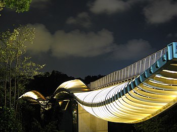
Singapore is a international conferences and events. Singapore is also a member of the United Nations, the World Trade Organization, the East Asia Summit, the Non-Aligned Movement, and the Commonwealth of Nations. (Full article... )Selected article - " consumerists of insipid taste. The article was accentuated by local news reports of criminal trials by which the author illustrated his observations, and bracketed by contrasting descriptions of the Southeast Asian airports he arrived and left by. (Full article... )Selected picture Henderson Waves, a 274-metre (900-foot) long pedestrian bridge connecting Mount Faber Park and Telok Blangah Hill Park. At 36 metres (120 feet) above Henderson Road, it is the highest pedestrian bridge in Singapore. Read more... General imagesThe following are images from various Singapore-related articles on Wikipedia.
Selected biography -
Johor Darul Takzim, while also serving as the assistant national coach on numerous occasions while and running his own Fandi Ahmad Academy. (Full article... )
Did you know (auto-generated)
In this month
More did you know -
Selected panorama
Singapore topicsRelated portalsSoutheast Asia Other Countries Tasks
CategoriesWikiprojectsAssociated WikimediaThe following Wikimedia Foundation sister projects provide more on this subject:
Discover Wikipedia using portals |


