
Quebec Route 219
| ||||
|---|---|---|---|---|
| North end | ||||
| Location | ||||
| Country | Canada | |||
| Province | Quebec | |||
| Highway system | ||||
| ||||
Route 219 is a
Mooers-Hemmingford Border Crossing south of Hemmingford and ends in Saint-Jean-sur-Richelieu
.
The highway starts at the border continuing from the former north terminus of
Autoroute 35 in Saint-Jean-sur-Richelieu
.
Municipalities along Route 219
- Hemmingford Township
- Hemmingford Village
- Saint-Patrice-de-Sherrington
- Saint-Cyprien-de-Napierville
- Napierville
- Saint-Jean-sur-Richelieu
-
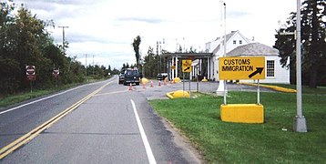 Mooers border station, southern terminus of Route 219.
 -
 Route 219 begins at Hemmingford border crossing.


Major intersections
| RCM | Location | km | mi | Destinations | Notes |
|---|---|---|---|---|---|
| Southern terminus | |||||
| Southern terminus of Route 205 | |||||
Saint-Patrice-de-Sherrington | Begin/end concurrency with Route 221 | ||||
Saint-Cyprien-de-Napierville | Exit 21 (A-15) | ||||
Napierville | Begin/end concurrency with Route 221 | ||||
Saint-Jean-sur-Richelieu | 55 | 34 | Exit 45 (A-35 / QC 104); northern terminus | ||
| 1.000 mi = 1.609 km; 1.000 km = 0.621 mi | |||||
See also
References
- ^ Ministère des transports, "Distances routières", page 83, Les Publications du Québec, 2005
External links
- Official Transport Quebec Road Map (in French)
- Route 219 on Google Maps
This Quebec road, road transport or highway-related article is a stub. You can help Wikipedia by expanding it. |