
Ōmuro Kofun group
大室古墳群 | |
Chubu region | |
| Coordinates | 36°35′23″N 138°13′51″E / 36.58972°N 138.23083°E |
|---|---|
| Type | kofun |
| History | |
| Periods | Kofun period |
| Site notes | |
| Public access | Yes (archaeological park) |
Ōmuro Kofun Group (大室古墳群, Ōmuro kofun-gun) is a group of late Chubu region of Japan. The site was collectively designated a National Historic Site of Japan in 1997.[1]
Overview
The Ōmuro Kofun Group is a large
Chikuma River at an elevation of 350 to 500 meters approximately six kilometers southeast of Nagano city. The tombs were built over a 250-year period from the 5th to the 8th centuries. They have been grouped by archaeologists into five groups ( Kanaiyama, Kitatani, Kajo, Omurodani, and Kitayama) by their geographic location, stretching across an area of roughly 2.5 square kilometers. [2]
There is only one
Haji ware pottery, bronze mirrors, armor, swords, horse fittings and jewelry. The number of horse bones found was unusually large, and included the skull of a horse which was buried in the vestibule of one of the horizontal burial chambers. [2]
The site is now an
archaeological park with a museum, the Ōmuro Kofun Museum (大室古墳館, Ōmuro kofun-kan) displaying some of the artifacts discovered. [2]
Access
- By car, 15 minutes from the Nagano IC on the Jōshin-etsu Expressway
- By bus, 20 minutes on foot from Ōmuro Station (大室駅, Ōmuro eki) (there are sign posts from the bus stop). From JR East Nagano Station, take the Nagaden Bus, No. 8, the Suzaka-Yashima Line, departing from the south exit of Nagano Station.
Gallery
-
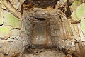 Burial chamber of Tomb 244
 -
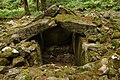 Tomb 168
 -
 Tomb 238
 -
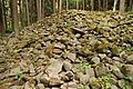
 Tomb 240
 -
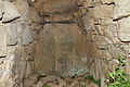 Burial chamber of Tomb 240
 -
 Tomb 276
 -
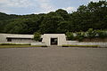 Ōmuro Kofun Museum


See also
References
- ^ "大室古墳群" (in Japanese). Agency for Cultural Affairs.
- ^ ISBN 4311750404.(in Japanese)
External links
Wikimedia Commons has media related to Omuro Kofun Group (Nagano).
- Nagano city cultural heritage database (in Japanese)
- Matsushiro tourist information site (in Japanese)
- Nagano city home page (in Japanese)