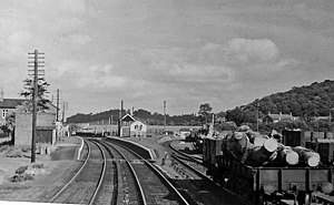
Abermule railway station
Abermule | |
|---|---|
 Abermule railway station in 1953 | |
| General information | |
| Location | Abermule, Powys Wales |
| Platforms | 3 |
| Other information | |
| Status | Disused |
| History | |
| Original company | Oswestry and Newtown Railway |
| Pre-grouping | Cambrian Railways |
| Post-grouping | Great Western Railway |
| Key dates | |
| 14 August 1860[1] | Opened |
| 14 June 1965[1] | Closed |

Abermule railway station served the village of
History
Opened by the Oswestry and Newtown Railway in 1860 (as a temporary rail head - the line to Welshpool not being ready until the following year) and then run by the Cambrian Railways, it became part of the Great Western Railway during the Grouping of 1923.[2] The Kerry branch line was opened in July 1863, with Abermule acting as the terminus for the passenger service. This was infrequent under Cambrian management (as few as one a day each way), though the GWR tried to improve loadings by opening two intermediate halts and increasing the service frequency after the grouping. By the late 1920s though, the timetable had shrunk back to just two return trips each weekday and these finally ended in February 1931.
The line then passed on to the
Abermule train collision
The Abermule train collision was a head-on collision which occurred between Abermule and Newtown on 26 January 1921, killing 17 people. The crash arose from misunderstandings between staff which effectively over-rode the safe operation of the Electric Train Tablet protecting the single line. A train departed carrying the wrong tablet for the section it was entering and collided with a train coming the other way.
The site today
Trains pass through the site on the
References
Sources
- OL 11956311M.
- Jowett, A. (2000). Jowett's Nationalised Railway Atlas. Atlantic Publishing. ISBN 0-906899-99-0.
Further reading
- Mitchell, Vic; Smith, Keith (2008). Shrewsbury to Newtown. Middleton Press. figs. 89-99. OCLC 228374968.
External links
| Preceding station | Historical railways | Following station | ||
|---|---|---|---|---|
| Montgomery Line open, station closed |
Cambrian Railways Oswestry and Newtown Railway |
Newtown Line and station open | ||
| Disused railways | ||||
| Terminus | Kerry Branch
|
Ffronfraith Halt Line and station closed | ||
