
Abu Dhalouf
Abu Dhalouf
أبو ظلوف | |
|---|---|
Town | |
 Aba Dalouf Street in Abu Dhalouf | |
 Abu Dhalouf Location in Qatar | |
| Coordinates: 26°7′25″N 51°10′0″E / 26.12361°N 51.16667°E | |
| Country | |
| Municipality | Al Shamal |
| Zone | Zone 78 |
| District no. | 396 |
| Area | |
| • Total | 2.0 sq mi (5.2 km2) |
Abu Dhalouf (
Etymology
In
Alternative transliterations of the name are Abu Dhaluf,[6] Abū Ḑalūf,[7] Abu Dhuluf,[8] and Abū Z̧ulūf.[9]
History
In the 1820s, George Barnes Brucks was tasked with preparing the first British survey of the Persian Gulf.[10] He wrote down the following notes about Abu Dhalouf, which he referred to as Boodeshoof:
"Boodeshoof, in lat. 26° 7' 50' N., long. 51° 16' E., is on the point nearly opposite Ras Reccan, and is subject to Bahrein, having about fifty men of the Abookara Tribe, mostly fishermen."[11]
-
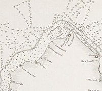 Abu Dhalouf as Boodeshoof in an 1824 map of the Qatar Peninsula based upon Brucks' research.

Captain Francis Prideaux, who was the British political resident in Bahrain, remarked in 1906 that, although Al Bidda was firmly under Al Thani-rule, the tribes of northern settlements, including Abu Dhalouf, did not pay tribute to the sheikh Jassim bin Mohammed Al Thani, nor did they consider themselves subjects of his. After investigating an act of piracy that took place off Abu Dhalouf, Prideaux learned the tribespeople of the village pledged their allegiance to the sheikh of Bahrain instead, as stated 80 years earlier by Brucks.[12]
A village on the north-west coast of the Qatar Promontory, near its tip and 1 or 2 miles south-west of
Ar Ru'ays. It is difficult of approach from seaward being fronted by a reef 2 1/2 miles broad which is nearly dry at low water. The inhabitants are about 70 families of the Manan'ah (Al Mannai) tribe owning 20 pearl boats [manned by 200 men], 5 other sea-going vessels and 10 fishing boats. Their drinking water is from the well of Umm Dha'an, about 1 1/2 miles inland. Camels here number 30.[13]
Reiterating details present in G.B. Brucks' earlier report, Lorimer also stated that prior to 1856, the village was inhabited by about 50 men of the Bu Kuwara (Kuwari) tribe.[14]
Landmarks

Many historic mosques exist in the town. Among the most notable of these mosques is Bahar Mosque, which was opened in 1940 and has since been restored by Qatar Museums.[15]
One of the most popular attractions in the town is Abu Dhalouf Park. It is situated along the Abu Dhalouf Beach, providing a vantage point of the Persian Gulf, and is also near the town center.[16] The park draws thousands of visitors every year from elsewhere in the north and from Doha. In 2016, it was reported that several locals had lodged complaints stating that the park had fallen into disrepair. They claimed that the landscaping and children's playground equipment were deteriorating, and that the park lacked suitable lighting at night. Thus, in April 2016, the Ministry of Municipality and Environment began a QR 12.5 million renovation that spanned the park's 17,000 m2 area.[17]
Education
The settlement's first formal school was opened in 1957.[18]
References
- ^ "District Area Map". Ministry of Development Planning and Statistics. Retrieved 20 May 2019.
- ^ "2013 population census" (PDF). Qatar Statistics Authority. Archived from the original (PDF) on 2 April 2015. Retrieved 13 March 2015.
- ^ "District map". The Centre for Geographic Information Systems of Qatar. Archived from the original on 24 November 2020. Retrieved 16 May 2015.
- ^ "Law No. 27 of 1988 On the Delimitation of the City of Abu Dhalouf". almeezan.qa. Retrieved 29 July 2015.
- ^ "GIS Portal". Ministry of Municipality and Environment. Archived from the original on 22 October 2020. Retrieved 24 May 2018.
- ^ "Abu Dhaluf: Qatar". geographic.org. Retrieved 17 March 2019.
- ^ "Abū Ḑalūf: Qatar". geographic.org. Retrieved 17 March 2019.
- ^ "Abu Dhuluf: Qatar". geographic.org. Retrieved 17 March 2019.
- ^ "Abū Z̧ulūf: Qatar". geographic.org. Retrieved 17 March 2019.
- ^ Mark Hobbs. "George Barnes Brucks and the First English Survey of the Gulf". Qatar Digital Library. Retrieved 19 January 2019.
- ^ G.B. Brucks; Robert Hughes Thomas (1856). "Historical and other information connected with place in the Persian Gulf". Bombay Education Society's Press. p. 561. This article incorporates text from this source, which is in the public domain.
- ^ Morton, Michael Quentin (4 November 2020). Masters of the Pearl: A History of Qatar. Reaktion Books. p. 77.
- ^ "'Gazetteer of Arabia Vol. I' [526] (557/1050)". Qatar Digital Library. Retrieved 28 July 2015. This article incorporates text from this source, which is in the public domain.
- ^ "'Persian Gulf Gazetteer Part II, Geographical and Descriptive Materials, Section II Western Side of the Gulf' [59v] (121/286)". Qatar Digital Library. Retrieved 28 July 2015. This article incorporates text from this source, which is in the public domain.
- ^ "'Mosques in Qatar: Then and Now' Exhibition Opens at Museum of Islamic Art". Qatar Museums. 22 June 2023. Retrieved 11 October 2023.
- ^ "Al Shamal Municipality: Vision and Development Strategy" (PDF). Ministry of Municipality and Environment. December 2017. p. 22. Retrieved 17 March 2019.
- ^ "منتزه أبو ظلوف ..مكان مهجور..وقرار تطويره وقف التنفيذ" (in Arabic). Al Sharq. 9 April 2016. Retrieved 17 March 2019.
- ^ Abdulla Juma Kobaisi (1979). "The Development of Education in Qatar, 1950–1970" (PDF). Durham University. pp. 41–42. Retrieved 19 December 2015.
| ||||||
| Zone 78 |
| |||||
| Zone 79 |
| |||||
| International | |
|---|---|
| National | |
This Qatari location article is a stub. You can help Wikipedia by expanding it. |