
Acaster South Ings
Notification 1988 | | |
| Location map | Magic Map (Defra) | |
|---|---|---|
Acaster South Ings is a
Site location and designation
Acaster South Ings is a 38.3 hectares (95 acres) biological Site of Special Scientific Interest (SSSI),[1] consisting of "two large alluvial flood-meadows."[2] The meadows are adjacent to the River Ouse and approximately 4 miles (6.4 km) south of York. Such wet grasslands are considered rare in the United Kingdom due to contemporary "drainage and agricultural improvement."[1][3] The site is accessed on foot via a public footpath along the Ouse riverbank, from Acaster Malbis via Acaster Marine.[4]
The SSSI was first
Significant site content
Flora
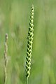
There are grasses such as great burnet, cock's-foot, creeping bent, meadow foxtail, Yorkshire fog and crested dog's tail.[1]
-
 Great burnet at Acaster South Ings
 -
 Cock's-foot at the site
 -
 Creeping bent
 -
 Meadow foxtail
 -
 Yorkshire fog
 -
 Crested dog's tail
.JPG)
.JPG)


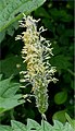
Flowering plants covering the flood meadow include
-
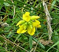 Meadow vetchling at Acaster South Ings
 -
 Sorrel or dock at the site
 -
 Red clover at the site
 -
 Creeping thistle at the site
 -
 Meadowsweet at the site
.JPG)
.JPG)
.JPG)
.JPG)
.JPG)
The site is protected, by earth
-
 Looking north across Acaster South Ings: grassland (left), dyke (right), riverside shrubs (background)
 -
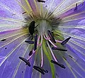
 Meadow cranesbill at Acaster South Ings
 -
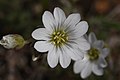 Field mouse ear
 -
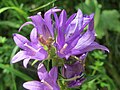 Clustered bellflower
 -
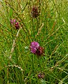
 Tansy at the site
 -
 Osiers at the site
.JPG)
.jpg)


.JPG)
.JPG)
Fauna
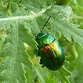
There are two beetles which are protected here. The rare tansy beetle[8] feeds on the leaves of the tansy plant, and Aphthona nigriceps (a flea beetle) lives on meadow cranesbill.[1][nb 1] Other insects here are scarab beetle Hoplia philanthus, red soldier beetle, pollen beetle and plant bug Leptoterna flavilabris. The curlew, a wading bird, breeds here. This is "one of few suitable breeding areas for waders" in the Vale of York, so dog walkers are advised to keep dogs on leads during the spring breeding season.[1][nb 2]
-
 Tansy beetle at Acaster South Ings
 -
 Pollen beetle on meadow cranesbill at the site
 -
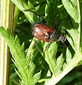 Scarab beetle at the site
 -
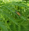
 Red soldier beetle at the site
 -
 Plant bug at the site
 -
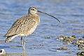 Curlew
.JPG)
.jpg)
.JPG)
.jpg)
.jpg)

Maintenance
"Active management" is required, to conserve the above flora and fauna.[9] Farming practices for the protection of the above species are: "continuation of traditional management for haycropping followed by aftermath grazing in late summer to early autumn."[1] To prevent tall growth and to avoid build-up of decayed vegetation, the fields are cut or mowed in early July after the curlews have bred and the protected plants have set seed. Grazing animals are removed in autumn. There is "regular and careful maintenance of surface drainage including ditches and drains."[9] The condition of the site is described by Natural England as "unfavourable - recovering."[10] The unfavourable condition was specified as "unfavourable development" in Hansard in 2004.[11]
Development and risk assessment
In 2018 the company Renewables First assessed the area for potential effects of the proposed Naburn Weir Hydroelectric Project. The assessment document concluded that the development was "not expected to have an adverse impact on the nearby SSSIs."[12]
Notes
References
- ^ a b c d e f g h Christian, Simon (1988). "Designated sites citation: Acaster South Ings" (PDF). Designated sites Natural England. Natural England. Retrieved 12 December 2019.
- ^ Symons, Bill (2014). "Biodiversity Action Plan 2013/2014, Table 3 national designations Vale of York" (PDF). Yorkconsort.gov.uk. Derwent House, Crockey Hill, York, YO19 4SR: York Consortium of Drainage Boards. p. 13. Retrieved 12 December 2019.
{{cite web}}: CS1 maint: location (link) - ^ "Magic Map: Acaster South Ings". Magic.defra.gov.uk. Natural England. Retrieved 10 December 2019.
- ^ "Footpaths map of Acaster Malbis area" (PDF). acastermalbis-pc.gov.uk/. Acaster Malbis Parish Council. Retrieved 12 December 2019.
- ^ Simon, Christian (1 May 1988). "Designated sites view: Acaster South Ings SSSI". Designatedsites.naturalengland.org.uk. Natural England. Retrieved 10 December 2019.
- ^ Hammond, Martin (2010). "City of York bioversity audit 20107.1.: Review of wildlife sites in the city of York" (PDF). Democracy.york.co.uk. City of York Council. p. 43. Retrieved 12 December 2019.
- ^ "About river and catchment". Yorkshire Dales Rivers Trust. 2014. Retrieved 12 December 2019.
- ^ "Chrysolina graminis (Linnaeus, 1758) [Tansy Beetle]". Nationally Biodiversity Network. 2012–2013. Retrieved 20 January 2020.
- ^ a b "Views about management" (PDF). Designated sites Natural England. Natural England. 1988. Retrieved 12 December 2019.
- ^ "Designated sites view: Acaster South Ings SSSI". Designated sites Natural England. Natural England. 1988. Retrieved 12 December 2019.
- ^ "Hansard: Sites of Special Scientific Interest". www.parliament.uk. House of Commons and House of Lords. 1 September 2004. Retrieved 12 December 2019.
- ^ Clutterbuck, Kelly (September 2018). "Naburn Weir Hydroelectric Project. Water Framework Directive Assessment. 3.28. Biodiversity and fish passage" (PDF). Cached. Renewables First. p. 10. Retrieved 12 December 2019.[dead link]