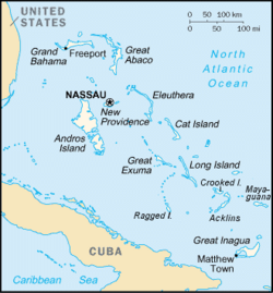
Acklins and Crooked Islands
This article needs additional citations for verification. (January 2014) |

Acklins and Crooked Islands was a
Bahamas until 1996, and as Acklins, Crooked Island and Long Cay until 1999. (islands are located at 22°30′N 74°0′W / 22.500°N 74.000°W)[1]
It consisted of a group of islands semi-encircling a large, shallow lagoon called the Bight of Acklins, of which the largest are Crooked Island in the north and Acklins in the south-east, and the smaller are Long Cay (once known as Fortune Island) in the north-west, and Castle Island in the south.[2][3]
The islands were settled by American
sponge
diving has now dwindled as well. The inhabitants now live by fishing and small-scale farming.
The main town in the group is
stevedores
seeking work on passing ships.
The population of Acklins was 428, and Crooked Island 350, at the 2000 census.
Since 1999, Acklins and Crooked Island are separate districts.
References
- ^ Crooked Island, Texas A&M University at Galveston, Retrieved November 6, 2013
- ^ Bahamas Out Islands: Acklins and Crooked Islands, Retrieved November 6, 2013
- ^ Acklins Crooked Island, Geographia.com, Retrieved November 6, 2013
