
Addlebrough
| Addlebrough | |
|---|---|
.jpg) Addlebrough from the north | |
| Highest point | |
| Elevation | 481 m (1,578 ft) |
| Prominence | 94 m |
| Coordinates | 54°17′22″N 2°05′13″W / 54.2895°N 2.0869°W |
| Geography | |
 Addlebrough Location in the Yorkshire Dales | |
| Location | North Yorkshire, England |
| OS grid | SD945881 |
Addlebrough is a fell in Wensleydale, North Yorkshire, England. It is 481 m (1,578 ft) high.
Bronze Age inhabitants built homes and enclosures on the fell's southern slopes.[1]
Gallery
-
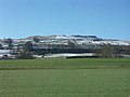 Addlebrough in winter, viewed from Askrigg Bottoms
 -
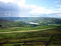 Semer Waterfrom Addlebrough


References
- General
- Addlebrough – My Yorkshire Dales
Wikimedia Commons has media related to Addlebrough.