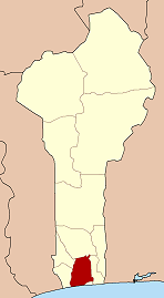
Ahouannonzoun
Ahouannonzoun | |
|---|---|
UTC+1 (WAT ) |
Ahouannonzoun is a town and
Institut National de la Statistique Benin on February 15, 2002, the arrondissement had a total population of 9,131.[1]
Like many areas of Benin, Ahouannonzoun is home to a non-sovereign monarchy.[2]
References
- ^ Institut National de la Statistique Benin Archived 2015-12-17 at the Wayback Machine, accessed by Geohive Archived 2012-01-10 at the Wayback Machine, accessed 19 January 2011
- ^ Canada, Immigration and Refugee Board of (2016-05-04). "Benin: Kings in northern Benin, specifically in Borgou department; extent of their power in comparison with the power of political and civil authorities; a king's ability to force a woman to marry him; remedies available to a woman who refuses to marry a king (2014-April 2016) [BEN105509.FE]". European Country of Origin Information Network. Archived from the original on 2021-05-06. Retrieved 2022-08-27.
6°39′44″N 2°07′11″E / 6.66222°N 2.11972°E

