
Angerlo
Angerlo | ||
|---|---|---|
 Former town hall | ||
|
Postal code 6986[1] | ||
| Dialing code | 0313 | |
Angerlo is a village in the municipality of Zevenaar, in the eastern Netherlands. It is located about 2 km south of Doesburg.
Until 1 January 2005, Angerlo was an independent municipality, with a population of about 5,000. This municipality included the villages of Bahr, Giesbeek and Lathum, and the hamlets of Bevermeer and Bingerden.
History
The village was first mentioned in 1025 as Angarlo, and means "forest near grassland".
Gallery
-
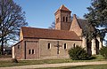 Angerlo, church
 -
 Huis Bingerden
 -
 Farm in Angerlo
 -
 Pig and farmer (1932)


References
- ^ a b c "Kerncijfers wijken en buurten 2021". Central Bureau of Statistics. Retrieved 26 March 2022.
- ^ "Postcodetool for 6986AA". Actueel Hoogtebestand Nederland (in Dutch). Het Waterschapshuis. Retrieved 26 March 2022.
- ^ "Angerlo - (geografische naam)". Etymologiebank (in Dutch). Retrieved 26 March 2022.
- ISBN 90 400 9406 3. Retrieved 26 March 2022.
- ^ "Angerlo". Plaatsengids (in Dutch). Retrieved 26 March 2022.
Wikimedia Commons has media related to Angerlo.
This Gelderland location article is a stub. You can help Wikipedia by expanding it. |