Apizaco
Apizaco | |
|---|---|
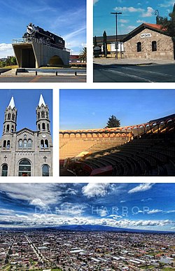
 Top:Apizaco little steam locomotive machine (La Maquinita de Apizaco), Piedra House Museum,
Second:Basilica of Santa Maria de la Misericordia (Apizaco Cathedral), Apizaco Bullring (Plaza de toros Apizaco), Bottom:Panoramic view of Apizaco (all item from left to right) | |
|
Central Daylight Time) | |
| Website | www |
Apizaco is a city in
must travel through Apizaco. The city began because of its location on this railroad.Universities in Apizaco include the Technological Institute of Apizaco (Instituto Tecnológico de Apizaco), and most recently, the University of the Valley of Tlaxcala (Universidad del Valle de Tlaxcala)
The city is the second in importance after the capital city,
The census of 2005 reported a population of 49,459 in the city of Apizaco, while the municipality had 73,097 inhabitants. The city is the second largest in the state in population, behind only
Etymology
The city gets its name from the
Geography
The city is located approximately 25 minutes by car from the state's capital city of Tlaxcala.
Climate
The city's climate is temperate and arid. Temperature in the winter can fall below 0°C, and in the summer, it can reach in excess of 30°C.
| Climate data for Apizaco (1951–2010) | |||||||||||||
|---|---|---|---|---|---|---|---|---|---|---|---|---|---|
| Month | Jan | Feb | Mar | Apr | May | Jun | Jul | Aug | Sep | Oct | Nov | Dec | Year |
| Record high °C (°F) | 29.0 (84.2) |
33.0 (91.4) |
32.1 (89.8) |
34.0 (93.2) |
35.2 (95.4) |
33.0 (91.4) |
30.0 (86.0) |
32.0 (89.6) |
34.0 (93.2) |
33.0 (91.4) |
29.0 (84.2) |
28.0 (82.4) |
35.2 (95.4) |
| Mean daily maximum °C (°F) | 20.8 (69.4) |
21.9 (71.4) |
24.0 (75.2) |
25.0 (77.0) |
25.0 (77.0) |
23.3 (73.9) |
22.5 (72.5) |
22.7 (72.9) |
22.2 (72.0) |
22.1 (71.8) |
21.7 (71.1) |
20.9 (69.6) |
22.7 (72.9) |
| Daily mean °C (°F) | 10.7 (51.3) |
11.8 (53.2) |
13.9 (57.0) |
15.2 (59.4) |
15.8 (60.4) |
15.6 (60.1) |
15.0 (59.0) |
15.0 (59.0) |
14.9 (58.8) |
13.9 (57.0) |
12.5 (54.5) |
11.1 (52.0) |
13.8 (56.8) |
| Mean daily minimum °C (°F) | 0.6 (33.1) |
1.8 (35.2) |
3.7 (38.7) |
5.3 (41.5) |
6.6 (43.9) |
8.0 (46.4) |
7.4 (45.3) |
7.2 (45.0) |
7.5 (45.5) |
5.6 (42.1) |
3.2 (37.8) |
1.4 (34.5) |
4.9 (40.8) |
| Record low °C (°F) | −9.0 (15.8) |
−8.0 (17.6) |
−7.0 (19.4) |
−5.0 (23.0) |
−4.3 (24.3) |
1.0 (33.8) |
0.0 (32.0) |
−1.0 (30.2) |
−3.0 (26.6) |
−7.0 (19.4) |
−7.0 (19.4) |
−9.0 (15.8) |
−9.0 (15.8) |
| Average precipitation mm (inches) | 9.4 (0.37) |
9.2 (0.36) |
12.5 (0.49) |
42.0 (1.65) |
87.3 (3.44) |
151.2 (5.95) |
138.7 (5.46) |
135.3 (5.33) |
129.3 (5.09) |
67.7 (2.67) |
17.9 (0.70) |
7.7 (0.30) |
808.2 (31.82) |
| Average precipitation days (≥ 0.1 mm) | 1.4 | 1.7 | 2.4 | 6.6 | 11.7 | 15.6 | 16.8 | 16.1 | 14.4 | 7.7 | 2.6 | 1.5 | 98.5 |
| Source: Servicio Meteorologico Nacional[1][2] | |||||||||||||
Transportation
Apizaco is close to Mexico City's proposed plan to make a new larger international airport near Apizaco to lessen the congested airspace. Ferrosur passes through Apizaco.
References
- ^ "Estado de Tlaxcala-Estacion: Apizaco". Normales Climatologicas 1951–2010 (in Spanish). Servicio Meteorologico Nacional. Archived from the original on 27 April 2015. Retrieved 27 April 2015.
- ^ "Extreme Temperatures and Precipitation for Apizaco 1928–2005" (in Spanish). Servicio Meteorológico Nacional. Archived from the original on 27 April 2015. Retrieved 27 April 2015.
External links
- Comité de Transparencia Apizaco Official website
- Link to tables of population data from Census of 2005 INEGI: Instituto Nacional de Estadística, Geografía e Informática
- Tlaxcala Enciclopedia de los Municipios de México
