
Arusha Declaration Monument
Mnara wa Azimio la Arusha (Swahili) | |
 The Arusha Declaration Monument | |
 | |
| 3°22′11″S 36°41′17″E / 3.3696°S 36.6880°E | |
| Location | Uhuru Roundabout, Swahili Street, Kati Ward, Arusha City, |
|---|---|
| Completion date | 1977 |
| Dedicated to | Arusha Declaration |
| Website | sites |
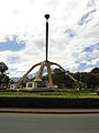
The Arusha Declaration Monument (
Kati ward in Arusha, Tanzania. It was unveiled in 1977 by the nation's ruling Chama Cha Mapinduzi (CCM) party to commemorate ten years of the Arusha Declaration.[1]
It is situated along Makongoro Road at the centre of the roundabout.
In April 2015, part of the monument was vandalised when one of its copper plaques was stolen.[2][3]
Gallery
-
-
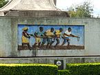 A mural depicting farmers working with hoes
 -
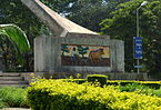 A mural depicting ploughing done with an animal


See also
References
- ISBN 978-1-4438-2204-6.
- ^ "Northern Tanzania's authorities grapple to rescue historic monuments from vandalism". Xinhuanet. 11 April 2015. Retrieved 5 August 2015.[dead link]
- ^ Mashalla, Moses (23 March 2015). "Mnara wa Azimio la Arusha 'umepoteza' historia yake" [Arusha Declaration Monument has 'lost' its history]. Mwananchi. Retrieved 5 August 2015.
This Tanzania-related article is a stub. You can help Wikipedia by expanding it. |