Assendelft
Assendelft | ||
|---|---|---|
Town | ||
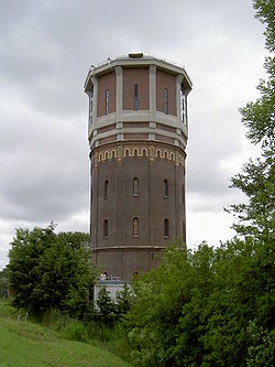
 The water tower of Assendelft | ||
|
Postal code 1566 & 1567[1] | ||
| Dialing code | 075 | |
| Major roads | A8 N8 / N246 N203 | |
Assendelft (Dutch pronunciation:
The North Sea Canal connects Assendelft with Amsterdam and Velsen, and it lies about 13 km northeast of Haarlem and about 15 km south of Alkmaar.
History
Assendelft is one of the oldest settlements in North Holland, with signs of settlement dating from as early as 500BC. The earliest written form of the name appears as 'Ascmannedilf' in 1063. The name is derived from the old Germanic word for Norsemen, 'Ascomanni', 'dilf' most likely meaning 'dug by'.
Train services
The town is served by Krommenie-Assendelft railway station. From here, there are four trains an hour to Amsterdam, with a journey time of 25 minutes.
Rural culture
Known is the local chicken breed, called "Assendelfter". It is an ancient pencilled breed, related to the pencilled Hamburg chicken.
References
- ^ a b c "Kerncijfers wijken en buurten 2021". Central Bureau of Statistics. Retrieved 2 May 2022.
two entries
- ^ "Postcodetool for 1566AA". Actueel Hoogtebestand Nederland (in Dutch). Het Waterschapshuis. Retrieved 2 May 2022.
- ^ Ad van der Meer and Onno Boonstra, Repertorium van Nederlandse gemeenten, KNAW, 2011.
- ^ "Assendelft [ZaanWiki]". www.zaanwiki.nl. Retrieved 2021-05-04.
- ^ "Amsterdam (GA)". CBS. 2014.
Grootstedelijke Agglomeratie Amsterdam

