
Barcelona–Cerbère railway
| Barcelona–Cerbère railway | |||||||||||||||||||||||||||||||||||||||||||||||||||||||||||||||||||||||||||||||||||||||||||||||||||||||||||||||||||||||||||||||||||||||||||||||||||||||||||||||||||||||||||||||||||||||||||||||||||||||||||||||||||||||||||
|---|---|---|---|---|---|---|---|---|---|---|---|---|---|---|---|---|---|---|---|---|---|---|---|---|---|---|---|---|---|---|---|---|---|---|---|---|---|---|---|---|---|---|---|---|---|---|---|---|---|---|---|---|---|---|---|---|---|---|---|---|---|---|---|---|---|---|---|---|---|---|---|---|---|---|---|---|---|---|---|---|---|---|---|---|---|---|---|---|---|---|---|---|---|---|---|---|---|---|---|---|---|---|---|---|---|---|---|---|---|---|---|---|---|---|---|---|---|---|---|---|---|---|---|---|---|---|---|---|---|---|---|---|---|---|---|---|---|---|---|---|---|---|---|---|---|---|---|---|---|---|---|---|---|---|---|---|---|---|---|---|---|---|---|---|---|---|---|---|---|---|---|---|---|---|---|---|---|---|---|---|---|---|---|---|---|---|---|---|---|---|---|---|---|---|---|---|---|---|---|---|---|---|---|---|---|---|---|---|---|---|---|---|---|---|---|---|---|---|---|
Iberian gauge | |||||||||||||||||||||||||||||||||||||||||||||||||||||||||||||||||||||||||||||||||||||||||||||||||||||||||||||||||||||||||||||||||||||||||||||||||||||||||||||||||||||||||||||||||||||||||||||||||||||||||||||||||||||||||||
| Electrification | 3 kV DC overhead lines | ||||||||||||||||||||||||||||||||||||||||||||||||||||||||||||||||||||||||||||||||||||||||||||||||||||||||||||||||||||||||||||||||||||||||||||||||||||||||||||||||||||||||||||||||||||||||||||||||||||||||||||||||||||||||||
| Operating speed | 160 km/h (99 mph) | ||||||||||||||||||||||||||||||||||||||||||||||||||||||||||||||||||||||||||||||||||||||||||||||||||||||||||||||||||||||||||||||||||||||||||||||||||||||||||||||||||||||||||||||||||||||||||||||||||||||||||||||||||||||||||
| |||||||||||||||||||||||||||||||||||||||||||||||||||||||||||||||||||||||||||||||||||||||||||||||||||||||||||||||||||||||||||||||||||||||||||||||||||||||||||||||||||||||||||||||||||||||||||||||||||||||||||||||||||||||||||
The Barcelona–Cerbère railway is a 168-kilometre (104.39 mi)
Perpinyà to Spain
.
History
It was built between 1858 and 1878 and electrified between 1981 and 1982 . It used to start at the Estació de França in Barcelona, but now starts at the Sants station.
Major Stations Along The Railway
Barcelona Sants railway station
Plaça De Catalunya railway station
Arc De Triomf Railway Station
El Clot-Aragó Railway Station
Sant Andreu Comtal Railway Station
Granollers Centre Railway Station
Gallery
-
 Barcelona Estació de França
 -
 Freight train on the line
 -
 Regional train
 -
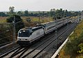 Estrella
 -

-
 Locomotive 252.075 with the Catalan Talgo.
 -
 A Civia 465+463 near Mollet - Sant Fost train station (Catalonia).
 -
 RENFE Class 449 in Montcada i Reixac train station.


.jpg)
Notes
See also
References
- Ministry of Public Works and Transport, Government of Spain. Archived from the original(PDF) on October 18, 2013. Retrieved June 27, 2014.
External links
![]() Media related to Bif. Sagrera-Cerbère railway line (Adif line 270) at Wikimedia Commons
Media related to Bif. Sagrera-Cerbère railway line (Adif line 270) at Wikimedia Commons
- Adif Archived 2014-07-16 at the Wayback Machine. Official website of the railway's owner
| ||||||||||||
| Rail service |
|  | ||||||||||
| Rolling stock |
| |||||||||||
| Infrastructure | ||||||||||||