
Beach Haven Historic District
Beach Haven Historic District | |
| NRHP reference No. | 83001608[1] (original) 14000933[2] (increase) |
|---|---|
| NJRHP No. | 2272, 5373 (increase)[3] |
| Significant dates | |
| Added to NRHP | July 14, 1983 |
| Boundary increase | November 19, 2014 |
| Designated NJRHP | April 20, 1983 |
The Beach Haven Historic District is a
contributing buildings.[5]
Gallery of contributing properties
-
-

-
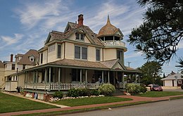
 Magnolia House
 -


References
- ^ "National Register Information System". National Register of Historic Places. National Park Service. November 2, 2013.
- ^ "Summary: Beach Haven Historic District (Boundary Increase and Additional Documentation)". National Park Service.
- ^ "New Jersey and National Registers of Historic Places – Ocean County" (PDF). New Jersey Department of Environmental Protection – Historic Preservation Office. September 13, 2018. p. 1.
- ^ Michael May (August 1981). "National Register of Historic Places Inventory/Nomination: Beach Haven Historic District". National Park Service. With Beach Haven Multiple Resource Area nomination
- ^ Margaret Westfield; Douglas C. McVarish (November 2013). "Beach Haven Historic District (Boundary Increase and Additional Documentation)" (PDF). National Park Service.
External links
- Historic American Buildings Survey (HABS) No. NJ-1102, "Holy Innocents Episcopal Church, Beach Avenue at Engleside Street, Beach Haven, Ocean County, NJ", 1 photo, 1 photo caption page