
Belmore, New South Wales
| Belmore Federal division(s) | |||||||||||||||
|---|---|---|---|---|---|---|---|---|---|---|---|---|---|---|---|
| |||||||||||||||
Belmore is a
History
Belmore is named after the fourth
The first school, Belmore South Primary School opened on 25 April 1892 and the post office opened in 1907.[
Heritage listings
Belmore has a number of heritage-listed sites, including:
- Burwood Road: Belmore railway station[3]
- 32-36 Redman Parade: Community facilities
- 481 Burwood Road: Doctor's surgery
- 543 Burwood Road: Electricity Substation No. 274
- 5 Knox Street: Electricity Substation No. 276
- 35 Isabel Street: Federation and Inter War House
- 37-37A Isabel Street: Federation and Inter War House
- 39 Isabel Street: Federation and Inter War House
- 2 Wilson Avenue: Federation Bakery, White House Bakery
- 436 Burwood Road: Federation detached house Station Master's house
- 37 Wilson Avenue: Federation House
- 52 Albert Street: Federation House
- 43 Wilson Avenue: Federation Weatherboard House
- 370-372 Burwood Road: Inter War Building Post Office (former)
- 35, 37 & 39 Isabel Street: Federation and Inter War House
- 2, 4, 6, 8, 10, 12, 14, 16, 18 Lakemba Street: Californian Bungalows Inter War House
- 103-105 Lakemba Street: Built in the 1920s
- 12 Oxford Street: Victorian House
- 31 Forsyth Street: Victorian Villa The Towers
Houses
Belmore has a high percentage of period homes.[citation needed] It is predominantly a low-rise residential area full of well-maintained period family homes with large back-yards, wide tree-lined streets, and small parks and playgrounds. Art Deco shop façades dominate the small shopping strip. There are now an increasing number of high-rise units in the suburb mostly along Canterbury Road.
Commercial area
Belmore contains a mixture of residential, significant landmarks, commercial and industrial developments. The main commercial area is located along Burwood Road, near Belmore railway station. Commercial and industrial developments are also located along Canterbury Road and surrounding streets.
-
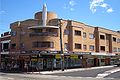 Art-decobuilding, corner Burwood Road and Bridge Road
 -
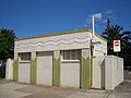 Art-decoamenities block
 -
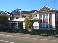
 Stationmaster's cottage on Burwood Road


Transport
Religious facilities
- Lien Hoa Temple, a Vietnamese Buddhist temple[4]
- All Saints Greek Orthodox Church
- St Alban's Anglican Church
- St Joseph's Catholic Church
- Belmore Church of Christ
- Al-Azhar Mosque - Located @ 172B Burwood Rd, Belmore
Schools
- The Heritage Listed Belmore South Public School was officially opened on the 22 January 1917.
- Belmore Boys' High is a small, comprehensive, multicultural high school.
- St Joseph's Primary School is a coeducational K-6 primary school.
- All Saints Grammar School is a co-educational Orthodox Christian School from Pre-Kindergarten to Year 12, run under the auspices of the Greek Orthodox Archdiocese of Australia.[5]
Gallery
-
 All Saints Greek Orthodox Church
 -
 St Joseph's Catholic Church
 -
 Belmore Boys High School
 -
![The Towers, a heritage-listed house in Forsyth Street[6]](//upload.wikimedia.org/wikipedia/commons/thumb/4/49/Belmore_The_Towers.JPG/120px-Belmore_The_Towers.JPG) The Towers, a heritage-listed house in Forsyth Street[6]
The Towers, a heritage-listed house in Forsyth Street[6]


![The Towers, a heritage-listed house in Forsyth Street[6]](/File:Belmore_The_Towers.JPG)
Sport
-
 Belmore Hotel
 -
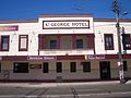 Belmore Brewery, St George Hotel
 -
 Canterbury Leagues Club


Demographics
According to the 2016 census of population, there were 12,718 residents in Belmore.
- 43.7% of residents were born in Australia, compared with the national average of 66.7%. The next most common countries of birth were Greece 6.3%, China 5.3%, Lebanon 4.1%, Vietnam 3.5% and South Korea 2.9%.
- 27.7% of people only spoke English at home. Other languages spoken at home included Greek 14.1%, Arabic 12.8%, Mandarin 4.6%, Vietnamese 4.4% and Korean 3.6%.
- The most common responses for religious affiliation were Catholic 24.1%, Eastern Orthodox 17.8%, No Religion 14.3% and Islam 12.9%.[1]
- The most common ancestries in Belmore were Greek 13.4%, Lebanese 9.5%, Chinese 8.7%, Australian 8.1% and English 8%.
References
- ^ a b Australian Bureau of Statistics (27 June 2017). "Belmore (State Suburb)". 2016 Census QuickStats. Retrieved 16 March 2018.
- ISBN 0-207-14495-8.
- .
- ^ "THÀNH VIÊN GIÁO HỘI". The Unified Vietnamese Buddhist Congregation of Australia - New Zealand. Retrieved 14 July 2021.
- ^ All Saints Grammar
- ^ State Heritage Register
External links
33°55′3″S 151°5′16″E / 33.91750°S 151.08778°E
- Lesley Muir and Brian Madden (2009). "Belmore". Dictionary of Sydney. Retrieved 25 September 2015. [CC-By-SA]
- Back to Belmore - Back to the Future, Back to Basics