
Berzasca
Berzasca | |
|---|---|
 Drencova ruins | |
 Location in Caraș-Severin County | |
 Berzasca Location in Romania | |
| Coordinates: 44°42′N 21°57′E / 44.700°N 21.950°E | |
| Country | Romania |
| County | Caraș-Severin |
| Area | 280.63 km2 (108.35 sq mi) |
| Population (2021-12-01)[1] | 2,132 |
| • Density | 7.6/km2 (20/sq mi) |
| Time zone | EET/EEST (UTC+2/+3) |
| Vehicle reg. | CS |
Berzasca (
Villages
| In Romanian | In Hungarian | In German | In Czech | In Serbian |
|---|---|---|---|---|
| Berzasca | Berszászka | Bersaska | Berzáska | Берзаска |
| Bigăr | Bigér | Schnellersruhe | Bígr Bygr |
Бигар |
| Cozla | Kozlatelep | Kozla | Козла | |
| Drencova | Drenkova | Дренкова | ||
| Liubcova | Alsólupkó | Libková Lubková |
Љупкова |
Bigăr
Bigăr is a remote
The village occurs north of the Sirinia Valley, a tributary of the Danube, this valley representing a
The villagers of Bigăr earn their living through farming and logging, while up to the early 1990s their main occupation was mining for the Jurassic coal which occurs abundantly in the Almăj Mountains. The natives of Bigăr represent a special community in which the Czech language is permanently used, including a dominant background of the old Czech language.[3][4] Today, the village includes mainly older people, while the youth work in the Czech Republic, most of them without immigrating, only to return home for summer holidays or for Christmas.[5][6] The popular clothes, rural architecture,[7] traditions and language are all well-preserved.
Bigăr occurs in the upper-middle part of the Sirinia sedimentary basin, also known as the Svinița - Svinecea Mare sedimentary zone, a basin including
The Lower Jurassic continental formation includes well developed bituminous coal seams, extracted until 1995 at Bigär (Palașca) mines, Buschmann, Stanca, Pietrele Albe, Camenița, Cozla and many other former sites, together with a rich fossil flora.Liubcova
Liubcova village was first attested in 1689 and bears a
Following the Turkish attacks of 1738, part of the
Liubcova's Romanian inhabitants are descended from people who lived in a former village on Veliki Breg (Serbian for "Great Hill"), which lies above today's village, 2 km to the east. During the Middle Ages, these individuals maintained the citadels at Dranco (today's Drencova) and Cozla, taking refuge together with the villagers of
-
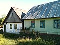 Houses in Bigăr
 -
 Bigăr village
 -
 A view of the Bigăr village from a hill


References
- ^ "Populaţia rezidentă după grupa de vârstă, pe județe și municipii, orașe, comune, la 1 decembrie 2021" (XLS). National Institute of Statistics.
- ^ Secká, M., 1995. Czechs in the Romanian Banat. Cesi e cizine, 8: 1-9.
- ^ Salzmann, Z., 1981. Naming persons in Bigăr, a Czech-speaking village in the Southern Romanian Banat, Southwest Educational Development Laboratory, Austin.
- ^ Salzmann, Z., 1984. Toponymy of the Bigăr region in the Romanian Banat. Anthropological Linguistics, 32(1-2): 139-148.
- ^ Willoughby, I., 2002, The Czech ethnic minority in Romania, Radio Prague.
- ^ Nica, A., 2002, Cehii din Banat si esenta vietii Archived 2011-09-30 at the Wayback Machine, Agenda.
- ^ Dokoupil, I., 2003, Fotogalerie Bigr, Prazdniny u krajanu Turistika v českých vesnicích rumunského Banatu.
- ^ Răileanu, G., 1953. Cercetări geologice în regiunea Svinița-Fața Mare. Bul. Șt., 5(2): 307-409.
- ^ Răileanu, G., 1960. Recherches geologiques dans la region Svinița-Fața Mare. Ann. Com. Geol., XXVI-XXVIII: 347-383.
- ^ Răileanu, G., Grigoraș, N., Onescu, N. and Plișca, T., 1963. Geologia zăcămintelor de cărbuni, cu privire specială asupra teritoriului RPR, București, 344 pp.
- ^ Petrescu, I., Nicorici, E., Bițoianu, C., Țicleanu, N., Todros, C., Ionescu, M., Mărgărit, G., Nicorici, M., Dușa, A., Pătruțoiu, I., Munteanu, A. and Buda, A., 1987. Geologia zăcămintelor de cărbuni. 2. Zăcăminte din Romania, 2. Editura Tehnică, Bucharest, 386 pp.
- ^ Codarcea, A., 1940. Vues nouvelles sur la tectonique du Banat meridional et du Plateau de Mehedinți. D. S. Inst. Geol. Rom., 20: 1-74.
- ^ a b c Plan Urbanistic General, comuna Berzasca, jud. Caraş-Severin[permanent dead link], at the Berzasca town hall site; accessed August 25, 2011
- ^ a b c d e "Liubcova" Archived August 20, 2011, at the Wayback Machine at the Berzasca town hall site; accessed August 25, 2011
