
Bodstedter Bodden

The Bodstedter Bodden is a lagoon, of the type known as a bodden, that is part of the Darss-Zingst Bodden Chain and the Western Pomerania Lagoon Area National Park in northeastern Germany. It lies south of the peninsula of Fischland-Darß-Zingst on the coast of Mecklenburg-Vorpommern. The heavily indented, reed fringed shoreline forms a picturesque landscape with the result that the villages near the shore are popular tourist destinations.
The western boundary of the
Fuhlendorf. To the northeast, the Prerower Strom
, a former estuary, empties into the bodden. The deepest point of the bodden (10 metres in depth) lies just in front of the Meininger Bülten, the small reed islands by Meiningen. The rest of the bodden is only rarely deeper than 3 metres.
Villages on the Bodstedter Bodden
- Born a. Darß
- Fuhlendorfand the village of Bodstedt that gives the bodden its name.
- Wieck a. Darß
-
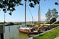 Old port in Bodstedt
 -
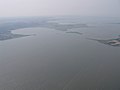 The Bodstedter Bodden and Redensee
 -
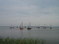 The Bodstedter Bodden seen from Bodstedt
 -
 Typical landscape by Bodden


External links
Wikimedia Commons has media related to Bodstedter Bodden.
- Literature about Bodstedter Bodden in the State Bibliography (Landesbibliographie) of Mecklenburg-Vorpommern