
Braunton
This article needs additional citations for verification. (March 2024) |
| Braunton | ||
|---|---|---|
Shire county | ||
| Region | ||
| Country | England | |
| Sovereign state | United Kingdom | |
| Post town | BRAUNTON | |
| Postcode district | EX33 | |
| Dialling code | 01271 | |
| Police | Devon and Cornwall | |
| Fire | Devon and Somerset | |
| Ambulance | South Western | |
| UK Parliament | ||
Braunton is a large village,
Toponymy
The origin of the name Braunton is unclear; there are two likely explanations for the name.
Topography
The
To the West of Braunton is Saunton and its beach and the sand dune system but bordering the village is what is reputed to be the largest remaining 'strip' farming area in the UK and which known as the 'Great Field' . Probably from medieval times and continuing today, this large area has been opened tilled without formal boundaries, with at least 3 families still involved in production. This boundary effect by the 'Great Field' now acts as a 'natural' barrier to the development of the town in that direction.[9]
During building works in the end of the 20th century, two strange findings revealed something of the areas geology. In one area of the village high on the side of the hill and about 100 feet (30 metres) above the flat area of the village, excavations for 1 m deep foundations of a house broke in to a pocket of sand which was found to extend greater than 5 m. The subsequent house had to be built on a raft on the sand. The sand was understood to have been examined by Exeter University, who considered it to have been a pocket pushed up by a glacier during the last ice age.[citation needed] At similar time in the flat area of the village, excavations for foundations revealed large sooth, rounded stones which were put down to a wide water course having been present at some time, rather than the small river that flows through the village now.[citation needed]
The presence of the river, the 'soft' water and permission for abstraction, encouraged an American company, 'Curity' to set up business in the village in the early 60's for the purposes of bleaching and processing imported raw cotton wool from the US into various products such as cotton wool balls, and rolls of perfectly white cotton for other companies to make such products as tampons and other medical/surgical products. Despite being in operation for about 40 years, the softness of the water and minimal [resin] 'ion exchange' meant that the 'Steambloc' boilers needed no treatment or aggressive cleaning.[citation needed]
Climate
Braunton has an oceanic climate that is heavily moderated by the proximity to the Atlantic. Although Braunton is not a coast town.
| Climate data for Chivenor RAF 1991–2020 | |||||||||||||
|---|---|---|---|---|---|---|---|---|---|---|---|---|---|
| Month | Jan | Feb | Mar | Apr | May | Jun | Jul | Aug | Sep | Oct | Nov | Dec | Year |
| Mean daily maximum °C (°F) | 9.1 (48.4) |
9.4 (48.9) |
11.2 (52.2) |
13.7 (56.7) |
16.5 (61.7) |
19.0 (66.2) |
20.5 (68.9) |
20.5 (68.9) |
18.8 (65.8) |
15.4 (59.7) |
12.1 (53.8) |
9.7 (49.5) |
14.7 (58.4) |
| Mean daily minimum °C (°F) | 3.7 (38.7) |
3.5 (38.3) |
4.4 (39.9) |
5.9 (42.6) |
8.6 (47.5) |
11.4 (52.5) |
13.3 (55.9) |
13.4 (56.1) |
11.5 (52.7) |
9.2 (48.6) |
6.2 (43.2) |
4.1 (39.4) |
7.9 (46.3) |
| Average precipitation mm (inches) | 90.1 (3.55) |
69.7 (2.74) |
59.5 (2.34) |
55.3 (2.18) |
54.0 (2.13) |
64.8 (2.55) |
73.7 (2.90) |
77.1 (3.04) |
69.9 (2.75) |
107.0 (4.21) |
106.4 (4.19) |
107.1 (4.22) |
934.6 (36.8) |
| Average precipitation days | 15.2 | 12.5 | 11.7 | 10.4 | 9.8 | 10.1 | 10.5 | 12.2 | 11.5 | 15.2 | 16.7 | 16.1 | 151.9 |
| Mean monthly sunshine hours | 59.7 | 79.3 | 136.2 | 194.5 | 219.6 | 209.6 | 203.1 | 189.8 | 153.8 | 107.5 | 64.2 | 51.8 | 1,669.1 |
| Source: Met Office[10] | |||||||||||||
History
Manors
Braunton was the chief
Braunton Dean
Braunton Dean, which probably represented the land granted by King
Braunton Abbots
Braunton Abbots, which extended also over part of the adjoining parish of
Braunton Gorges
Braunton Gorges,
Waleys, by a fine levied at Westminster in the octave of Michaelmas, 4 Edward III, granted to Ralph Gorges two-thirds of the manor of Braunton Gorges by the name of two-thirds of 3 messuages, 2 carucates of land and 100s. of rent in the same town of Braunton, together with the reversion of the third part thereof which John Pecche and Eleanor, his wife, both now deceased, held as dower of the said Eleanor of the inheritance of the aforesaid Walter, to hold the same to himself and the heirs male of his body, with remainder in default of such heirs to William son of Theobald Russell and the heirs male of his body, and remainder in default of such heirs to Theobald brother of the said William and the heirs male of his body, and that the said Ralph and William died without heirs male of their bodies, and that Theobald brother of William entered the premises by virtue of the said fine, took to wife Agnes late the wife of Theobald Gorges, " chivaler," had issue by her Bartholomew Gorges and Thomas Gorges, and died seised of the premises, after whose death the said Bartholomew entered the manor as his son and heir male, and died seised of the two-thirds aforesaid without leaving an heir male of his body, so that the two-thirds and reversion ought to remain to the said Thomas, who is of full age, as brother and heir male of Bartholomew, and that the manor is
Forest of Exemore, "to take the fealty of the said Thomas, and cause him to have full seisin of the said two-thirds and reversion".
Sir Theobald de Gorges (d. 1381) died seized of this estate and was succeeded by his son Ralph de Gorges, succeeded by his son Bartholomew de Gorges.[21] In 1810 it was owned, together with Ash, Fullabrook and Braunton Park, by Joseph Davie Basset (1764–1846), later of Watermouth Castle, near Lynmouth, son of John Davie of Orleigh Court, near Bideford, by his wife Eleanora Basset, sister and heiress of Francis Basset (c. 1740–1802) of Heanton Punchardon and Umberleigh.[16] In accordance with the terms of the inheritance, as was then usual in such cases, Joseph Davie and his descendants adopted the arms and surname of Basset in lieu of their patronymic.
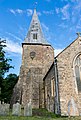
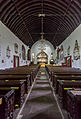
St Brannock's Church
The
Monuments and furnishings
In the floor of the choir is an unusual
St. Brannock
In 550 the
Brannock probably came to North Devon with one such raid and is said to have landed at Saunton Sands, then dense woodland before later wind-erosion into sand-dunes, at the mouth of the River Taw. Brannock settled among a tribe of local Britons and soon established a strong Christian community. A church, the first in North Devon, was built near where the Caen Stream began to spread its waters on the alluvial lands around the River Taw. Brannockstood, the township that grew up around this church, later became Brantone and at the end of the 19th century, Braunton.
The story has it that Brannock tried to build the church on the hill overlooking the settlement but it kept being damaged by the weather and in a dream he saw a pigsty with piglets. At the foot of the hill he built the current church over the sty where it still remains, and the central wooden boss in the church depicts a sow and piglets. The remains of the original church remain on the hill.
Demography
The population of Braunton, according to the census of 1801, was 1,296. This number increased quite rapidly in the thirty years to 1831, to 2,047 however the rate of increase slowed during the next 10 years and coinciding with the arrival of the railway fell from 2,364 in 1851 to 2,089 in 1881. Population growth resumed and saw almost a doubling between 1961 and 2011, to 8,128 people. Data for 1801–1961 is available at Britain Through Time.
| Year | 1801 | 1811 | 1821 | 1831 | 1841 | 1851 | 1881 | 1891 | 1901 |
|---|---|---|---|---|---|---|---|---|---|
| Population | 1,296 | 1,390 | 1,699 | 2,047 | 2,274 | 2,364 | 2,089 | 2,171 | 2,135 |
| Year | 1911 | 1921 | 1931 | 1941 | 1951 | 1961 | 2001 | 2011 | 2021 |
| Population | 2,328 | 2,644 | 3,019 | n/a | 3,819 | 4,303 | 7,510 | 8,128 | 10,217 |
Historic estates
Several of the historic estates within the parish of Braunton have expanded into larger settlements. They include:
Saunton

The
Knowle

Higher above the village is Knowle commencing within 1 mile (1.6 km) to the northwest.
Wrafton
Lobb and North Lobb
Ash
Fullabrook
Fullabrook was the home of Sir
Incledon
Buckland
Events
The village holds a Town carnival each year near the end of May.
Tourism
There are a range of surfing shops located in Braunton.
Facilities
The town has a few hotels and guesthouses and numerous shops (including a large Supermarket) and pubs. The town also boasts a secondary school and three primary schools. It also has multiple skating areas, one with a skating bowl and the other featuring several small ramps.
Surfing
Since the closing years of the 20th century, the village has become a hub for
A number of major surf brands are associated with the village including Tiki, Board Barn, Tokyo, Demons Of Doom Killers, Rusty Peach, Modern Foam Designs and Salt Rock.[citation needed]
Transport
Braunton is served by the following bus services:
- 21/21A Westward Ho!/Appledore - Bideford - Barnstaple - Braunton - Georgeham/Ilfracombe (Stagecoach)
- 303 Woolacombe - Braunton - Barnstaple (Filers)
- 502 to London (National Express)
Notable residents
- Charlotte Eliza Bousfield (formerly Collins), the noted diarist, was born at Braunton.
Twin towns
See also
Braunton gallery
This section contains an unencyclopedic or excessive gallery of images. |
-
 Bench Ends
 -
 MainBlowout (geology) dune at Braunton Burrows
 -
 Braunton Burrows in Devon
 -
 Braunton Burrows
 -
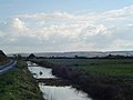 Braunton Marshes and swans. Taken from Marsh Road
 -
 Braunton village centre (2003)
 -
 Braunton Tesco
 -
 Scurfield Close leading off from the road to Georgeham
 -
 Velator Quay. looking back up the River Caen towards East Hill, Braunton
 -
 Mural at the Braunton Recreation Ground
 -
 A reminder of Braunton's railway. Rails left in the road at a level crossing in Braunton
 -
 Braunton and the Great Field beyond
 -
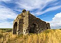 St. Michael's Chapel Ruin
 -
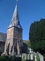 St Brannock's Church
 -
 St Brannock's Church
 -
 St Brannock's Church
 -
 St Brannock's Church
 -
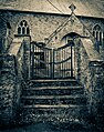
 Cemetery of the St Brannock's Church
 -
 Goods Shep of the old Railway Station; today the Museum of British Surfing
 -
 Station House of the old Railway Station
 -
 Braunton & District Museum
 -
 "Black Horse Inn”
 -
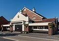
 Fire Station
 -
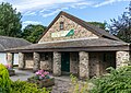 Countryside Centre
 -
 Parish Hall
 -
 Memorial
 -
 Memorial Garden


,_Braunton_Burrows_--_2013_--_1837.jpg)


,_St_Brannock%27s_Church_--_2013_--_00175_(kreativ).jpg)
,_St_Brannock%27s_Church_--_2013_--_4.jpg)
,_St_Brannock%27s_Church_--_2013_--_5.jpg)
,_St_Brannock%27s_Church_--_2013_--_9.jpg)
,_Old_Railway_Station,_Sidings_(Museum_of_British_Surfing)_--_2013_--_00205.jpg)
,_Old_Railway_Station,_Station_House_--_2013_--_00190.jpg)
,_Braunton_%26_District_Museum_--_2013_--_00191.jpg)
,_Black_Horse_Inn_--_2013_--_00169.jpg)
,_Fire_Station_--_2013_--_00156.jpg)
,_Countryside_Centre_--_2013_--_00192.jpg)
,_Parish_Hall_--_2013_--_00228.jpg)
,_Memorial_--_2013_--_00227.jpg)
,_Memorial_Garden_--_2013_--_00229.jpg)
Notes and references
- Notes
- ^ Its purpose as set out in its cover description was "the Inclosing, Draining and Embanking Lands in Braunton, in the County of Devon."
- References
- ^ a b "South West England (United Kingdom): Counties and Unitary Districts & Settlements - Population Statistics, Charts and Map".
- ^ "Parish Headcounts: North Devon". Parish census 2011. Retrieved 20 February 2015.
- ^ "Braunton East ward 2011". Retrieved 20 February 2015.
- ^ "Braunton West ward 2011". Retrieved 20 February 2015.
- ^ "Braunton :: Survey of English Place-Names". epns.nottingham.ac.uk. Retrieved 16 April 2023.
- ^ "Surname Database: Brampton Last Name Origin". The Internet Surname Database. Retrieved 16 April 2023.
- ^ bbc.co.uk Archived 20 August 2007 at the Wayback Machine Devon/Outdoors/Nature. Retrieved 13 July 2013
- ^ Clare Manning, (2007), Braunton Marsh Management Scheme, Taw Torridge Estuary Forum Archived 8 October 2007 at the Wayback Machine
- ^ "North Devon Coast". North Devon Coast - Area of Outstanding Natural Beauty. Retrieved 18 March 2022.
- ^ "UK climate averages".
- ^ Thorn, Caroline & Frank, (eds.) Domesday Book (Morris, John, gen.ed.), Vol. 9, Devon, Parts 1 & 2, Phillimore Press, Chichester, 1985, part 2 (notes) 1,5
- ^ Thorn & Thorn, part 2 (notes), chap.16; part 1, chapter 16: 1–176
- ^ a b c d Thorn & Thorn, part 2, 1,5
- ^ a b Risdon, Tristram (d.1640), Survey of Devon, 1811 edition, London, 1811; 1810 Additions, p.429
- ^ Lord Courtenay, per Risdon, 1810 Additions, p.429
- ^ a b Risdon, 1810 Additions, p.429
- Close Rolls, 1324
- ^ See
- ^ regnal year 4 Edward III
- ^ Calendar of Fine Rolls, membrane 25, p.194 Archived 15 February 2015 at the Wayback Machine
- ^ Pole, Sir William (d. 1635), Collections Towards a Description of the County of Devon, Sir John-William de la Pole (ed.), London, 1791, p. 395
- ^ Listing comprising seven paragraphs of architectural details (Betjeman, J. (ed.) (1968) Collins Pocket Guide to English Parish Churches: the South. London: Collins; p. 159-60; St Brannock's Church – Grade I Listing – Historic England. "Details from listed building database (1325560)". National Heritage List for England. Retrieved 13 July 2013.
- ^ St Brannock's church website Archived 6 December 2009 at the Wayback Machine – includes history page
- ^ Vivian, p.107; per inscription on brass
- ^ Lysons, Daniel & Lysons, Samuel, Magna Britannia, Vol.6, Devonshire, London, 1822
- ^ Vivian, p.173, pedigree of Chichester
- ^ Pole, Sir William (d.1635), Collections Towards a Description of the County of Devon, Sir John-William de la Pole (ed.), London, 1791, p.396
- ^ Risdon, p.338
- ^ "Braunton through time : Population Statistics : Total Population". A Vision of Britain through Time. Retrieved 13 July 2013.
- ^ Venn, John, Biographical History of Gonville and Caius College 1349–1897, 2 volumes, Vol. 1, Cambridge, 1897, p. 445; Vivian, Lt. Col. J. L. (ed.), The Visitations of the County of Devon: Comprising the Heralds' Visitations of 1531, 1564 & 1620, Exeter, 1895, p. 633
- ^ "The Museum Story". Museum of British Surfing. Retrieved 13 August 2016.
- ^ Booth, Robert (24 August 2012). "Wave hello: the birth of British surfing". Guardian. Retrieved 13 August 2016.
- ^ Blackburn, Chris (24 December 2011). "Apple dealer was the heart of parties he loved". Western Daily Press.
External links
- Braunton Parish Council
- Braunton at Curlie
- The Explore Braunton Project
- Tourist Information Centre
- Christ Church
- Braunton at GENUKI

| International | |
|---|---|
| National | |