
Bubikon
Bubikon | |
|---|---|
_IMG_4631.JPG) | |
 Coat of arms | |
Location of Bubikon  | |
Rüti | |
| Website | www SFSO statistics |
Bubikon is a
History


_-_Bubikon_Widerzell_IMG_4941.JPG)

Some names of localities have
Geography
Bubikon has an area of 11.6 km2 (4.5 sq mi). Of this area, 62.4% is used for agricultural purposes, 13.2% is forested, 19.2% is settled (buildings or roads) and the remainder (5.2%) is non-productive (rivers, glaciers or mountains).[4] In 1996[update] housing and buildings made up 12.4% of the total area, while transportation infrastructure made up the rest (6.6%).[5] Of the total unproductive area, water (streams and lakes) made up 0.8% of the area. As of 2007[update] 17.2% of the total municipal area was undergoing some type of construction.[5]
The municipality is located in the upper Glatt Valley on the water divide between the Glatt river and Lake Zurich. It includes the villages of Bubikon and Wolfhausen as well as the hamlets of Barenberg, Berlikon, Bürg and Wändhüslen.
The Egelsee lake is located in the municipality.
Demographics
Bubikon has a population (as of 31 December 2020) of 7,371.[6] As of 2007[update], 8.7% of the population was made up of foreign nationals. As of 2008[update] the gender distribution of the population was 49.5% male and 50.5% female. Over the last 10 years the population has grown at a rate of 17.7%. Most of the population (as of 2000[update]) speaks German (93.6%), with Italian being second most common ( 2.1%) and Albanian being third ( 0.9%).
In the 2007 election the most popular party was the SVP which received 37.7% of the vote. The next three most popular parties were the SPS (15.6%), the CSP (12%) and the Green Party (10%).
The age distribution of the population (as of 2000[update]) is 25% children and teenagers (0–19 years old), whereas adults (20–64 years old) make up 62.6% and seniors (over 64 years old) make up 12.4%. The entire Swiss population is generally well educated. In Bubikon about 80.7% of the population (between age 25-64) have completed either non-mandatory upper secondary education or additional higher education (either university or a Fachhochschule). There are 2125 households in Bubikon.[5]
Bubikon has an unemployment rate of 1.15%. As of 2005[update], there were 145 people employed in the primary economic sector and about 50 businesses involved in this sector. 1,031 people are employed in the secondary sector and there were 84 businesses in this sector. 1,274 people are employed in the tertiary sector, with 203 businesses in this sector.[4] As of 2007[update] 46.1% of the working population were employed full-time, and 53.9% were employed part-time.[5]
As of 2008[update] there were 1,666
The historical population is given in the following table:[3]
| year | population |
|---|---|
| 1634 | 262 |
| 1850 | 1,591 |
| 1870 | 1,489 |
| 1900 | 1,555 |
| 1920 | 1,809 |
| 1950 | 2,265 |
| 1970 | 3,244 |
| 2000 | 5,424 |
Transport
Bubikon railway station is a stop of the Zürich S-Bahn on the lines S15 and S5. Its train station is a 25-minute (S5) ride from Zürich Hauptbahnhof.
Gallery
-
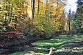
 Schwarz river in Bubikon, Schwarztöbeli waterfall in the background
 -
 Schwarztöbeli valley between Bubikon andRüti
 -
 Giessenbach valley and stream
 -
 Bubikon as seen from the cemetery at the Reformed church
 -
 Reformed church (built around 1192 AD)
 -
 Gemeindehaus (town hall) nearby Reformed church
 -
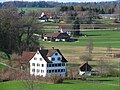 A farm, typical for the region Bubikon-Wolfhausen: farmhouse, bathhouse and barn
 -
 Barenberg, a small hamlet between the village of Wolfhausen and Kempraten
_-_Schwarzt%C3%B6beli_IMG_9266.JPG)


_IMG_9418_ShiftN.jpg)
References
- ^ a b "Arealstatistik Standard - Gemeinden nach 4 Hauptbereichen". Federal Statistical Office. Retrieved 13 January 2019.
- ^ "Ständige Wohnbevölkerung nach Staatsangehörigkeitskategorie Geschlecht und Gemeinde; Provisorische Jahresergebnisse; 2018". Federal Statistical Office. 9 April 2019. Retrieved 11 April 2019.
- ^ a b Bubikon in German, French and Italian in the online Historical Dictionary of Switzerland.
- ^ a b Swiss Federal Statistical Office Archived January 5, 2016, at the Wayback Machine accessed 06-Aug-2009
- ^ a b c d e Statistics Zurich (in German) accessed 4 August 2009
- ^ "Ständige und nichtständige Wohnbevölkerung nach institutionellen Gliederungen, Geburtsort und Staatsangehörigkeit". bfs.admin.ch (in German). Swiss Federal Statistical Office - STAT-TAB. 31 December 2020. Retrieved 21 September 2021.
External links
- Official website (in German)
- Bubikon in German, French and Italian in the online Historical Dictionary of Switzerland.
| International | |
|---|---|
| National | |
| Geographic | |
| Other | |