Bungo Channel
Appearance
| Bungo Channel | |
|---|---|
| 豊後水道 (Japanese) | |
 Bungo Channel Map | |
| Location | Japan |
| Coordinates | 32°54′32″N 132°15′00″E / 32.909°N 132.25°E |
| Type | Strait |
| Basin countries | Japan |
| Settlements | Ōita, Uwajima, Seiyo, Sukumo |
| References | Bungo Strait: Japan National Geospatial-Intelligence Agency, Bethesda, MD, USA |
| Location | |
 | |
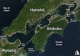
The Bungo Channel (豊後水道, Bungo-suidō[1]) is a strait separating the Japanese islands of Kyushu and Shikoku. It connects the Philippine Sea and the Seto Inland Sea on the western end of Shikoku.[2] The narrowest part of this channel is the Hōyo Strait.
In the
Run Silent, Run Deep, based upon the best-selling 1955 novel by then-Commander Edward L. Beach Jr.[3]
Notes
- ISBN 4-8071-0004-1
- Nussbaum, Louis-Frédéric. (2005). "Bungo Kaikyō"in Japan Encyclopedia, p. 91.
- ^ Sheffield, Richard. (2009). Subs on the Hunt: 40 of the Greatest WWII Submarine War Patrols, p. 24, at Google Books; Leeman, Sergio and Robert Wise. (1995). Robert Wise on his Films: from Editing Room to Director's Chair, p. 145.
References
- Leeman, Sergio and Robert Wise. (1995). Robert Wise on his Films: from Editing Room to Director's Chair. Los Angeles: Silman-James. ISBN 9781879505247; OCLC 243829638
- Nussbaum, Louis-Frédéric and Käthe Roth. (2005). Japan encyclopedia. Cambridge:
- Sheffield, Richard. (2009). Subs on the Hunt: 40 of the Greatest WWII Submarine War Patrols. Atlanta: Fox Publishing. ISBN 9781442169388; OCLC 652102659

