
Buramsan
| Buramsan | |
|---|---|
 | |
| Highest point | |
| Elevation | 507 m (1,663 ft) |
| Coordinates | 37°33′58″N 127°06′9″E / 37.56611°N 127.10250°E |
| Geography | |
 Buramsan  Buramsan Buramsan (South Korea) | |
| Climbing | |
Sanggye Station | |
| Korean name | |
| Hangul | 불암산 |
| Hanja | |
| Revised Romanization | Buramsan |
| McCune–Reischauer | Puramsan |
Buramsan (
Gyeonggi-do. It has an elevation of 507 m (1,663 ft).[1] It also has a heliport at the second peak (420 m (1,378 ft)).[citation needed
]
Gallery
-
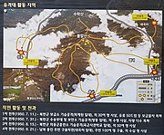 Signpost showing military action on the mountain during the Korean War
 -
 A cave on the mountain used during the Korean War


See also
References
- ISBN 978-89-958055-1-0.