
Cabo Rojo barrio-pueblo
Cabo Rojo barrio-pueblo
Pueblo de Cabo Rojo | ||
|---|---|---|
Municipality Seat ZIP code 00623 | ||
Cabo Rojo barrio-pueblo is a barrio and the administrative center (seat) of Cabo Rojo, a municipality of Puerto Rico. Its population in 2010 was 1,078.[1][4][5]
As was customary in Spain, the municipality in Puerto Rico has a barrio called pueblo which contains a central plaza, the municipal buildings (city hall), and a Catholic church. Fiestas patronales (patron saint festivals) are held in the central plaza every year.[6][7]
The central plaza and its church
The central plaza, or square, is a place for official and unofficial recreational events and a place where people can gather and socialize from dusk to dawn. The Laws of the Indies, Spanish law, which regulated life in Puerto Rico in the early 19th century, stated the plaza's purpose was for "the parties" (celebrations, festivities) (Spanish: a propósito para las fiestas), and that the square should be proportionally large enough for the number of neighbors (Spanish: grandeza proporcionada al número de vecinos). These Spanish regulations also stated that the streets nearby should be comfortable portals for passersby, protecting them from the elements: sun and rain.[6]
Located across from the central plaza in Cabo Rojo barrio-pueblo is the Parroquia San Miguel Arcángel which was built between 1771 and 1783. Partly destroyed by lightning in 1861, the roof was rebuilt. Its current facade was designed by Onofre Llompart and its construction began in 1878. In 1965, the roof was changed as well as the church interior.[8]
History
Cabo Rojo barrio-pueblo was in Spain's
| Census | Pop. | Note | %± |
|---|---|---|---|
| 1900 | 2,744 | — | |
| 1910 | 3,847 | 40.2% | |
| 1920 | 4,327 | 12.5% | |
| 1930 | 4,605 | 6.4% | |
| 1940 | 5,303 | 15.2% | |
| 1950 | 4,797 | −9.5% | |
| 1960 | 3,086 | −35.7% | |
| 1970 | 0 | −100.0% | |
| 1980 | 1,917 | — | |
| 1990 | 1,527 | −20.3% | |
| 2000 | 1,305 | −14.5% | |
| 2010 | 1,078 | −17.4% | |
| U.S. Decennial Census 1899 (shown as 1900)[11] 1910-1930[12] 1930-1950[13] 1980-2000[14] 2010[15] | |||
In July 2020, Federal Emergency Management Agency appropriated funds for repairs to Cabo Rojo's plaza.[16]
Gallery
Places in Cabo Rojo barrio-pueblo:
-
 Welcome to Cabo Rojo monument
 -
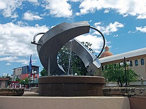 Fountain in the Cabo Rojo plaza (plaza de recreo)
 -
 Statue of Ramón Emeterio Betances and Catholic church
 -
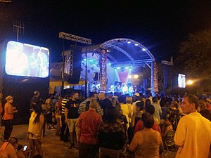 Patron Saint festival in Cabo Rojo


See also
References
- ^ a b Puerto Rico: 2010 Population and Housing Unit Counts.pdf (PDF). U.S. Dept. of Commerce, Economics and Statistics Administration, U.S. Census Bureau. 2010.
- ^ a b "US Gazetteer 2019". US Census. US Government.
- ^ U.S. Geological Survey Geographic Names Information System: Cabo Rojo barrio-pueblo
- ^ Picó, Rafael; Buitrago de Santiago, Zayda; Berrios, Hector H. Nueva geografía de Puerto Rico: física, económica, y social, por Rafael Picó. Con la colaboración de Zayda Buitrago de Santiago y Héctor H. Berrios. San Juan Editorial Universitaria, Universidad de Puerto Rico,1969.
- ISBN 978-1-4766-0447-3. Retrieved 25 December 2018.
- ^ JSTOR j.ctvbcd2vs.12.
- ^ Pariser, Harry S. (2003). Explore Puerto Rico, Fifth Edition. San Francisco: Manatee Press. pp. 52–55. Retrieved 10 February 2019.
- ^ Mari Mut, José A. (2013-08-28). Los Pueblos de Puerto Rico y Las Iglesias de Sus Plazas [The Pueblos of Puerto Rico, and the Churches of its Plazas] (PDF) (in Spanish). pp. 43–45. Archived (PDF) from the original on 2020-12-14. Retrieved 2021-07-29.
- ^ "Anuario del comercio, de la industria, de la magistratura y de la administración. 1881". Biblioteca Nacional de España (in Spanish). p. 1614. Retrieved 4 April 2023.
- ^ Joseph Prentiss Sanger; Henry Gannett; Walter Francis Willcox (1900). Informe sobre el censo de Puerto Rico, 1899, United States. War Dept. Porto Rico Census Office (in Spanish). Imprenta del gobierno. p. 164.
- ^ "Report of the Census of Porto Rico 1899". War Department Office Director Census of Porto Rico. Archived from the original on July 16, 2017. Retrieved September 21, 2017.
- ^ "Table 3-Population of Municipalities: 1930 1920 and 1910" (PDF). United States Census Bureau. Archived (PDF) from the original on August 17, 2017. Retrieved September 21, 2017.
- ^ "Table 4-Area and Population of Municipalities Urban and Rural: 1930 to 1950" (PDF). United States Census Bureau. Archived (PDF) from the original on August 30, 2015. Retrieved September 21, 2014.
- ^ "Table 2 Population and Housing Units: 1960 to 2000" (PDF). United States Census Bureau. Archived (PDF) from the original on July 24, 2017. Retrieved September 21, 2017.
- ^ Puerto Rico: 2010 Population and Housing Unit Counts.pdf (PDF). U.S. Dept. of Commerce Economics and Statistics Administration U.S. Census Bureau. 2010. Archived (PDF) from the original on 2017-02-20. Retrieved 2019-08-02.
- ^ "FEMA Approves Funds to Repair PR Town Squares". Hudson Valley Press. 2020-07-08. Retrieved 2021-09-23.