Camp O'Ryan
Camp O'Ryan is a 375-acre (1.52 km2) former
History


Camp O'Ryan, which was opened in late 1949 or early 1950, was initially called the Wethersfield training area. It was designed for the
During the Korean and Vietnam Wars, the use of Camp O'Ryan increased as many National Guardsmen trained at the site. A multipage article in the Buffalo Courier-Express, run on November 10, 1968, depicted some of the training done at this camp. This included rifle target practice as well as pistol training.
Training there ceased in 1974, although may have been used by other agencies as late as the mid-1980s. Originally a
The property was owned by Edward N. George Jr. (a.k.a. Ed Don George), wrestler, promoter, and naval commander. He leased it to the Federal Government for 25 years almost immediately after purchasing the property from Charles R. Greenan in 1949.[2][8][9]Environmental concerns

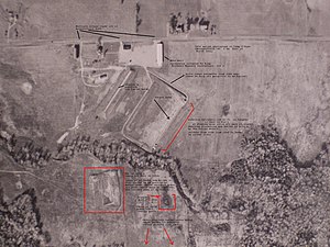
Photographs of this site indicate there was an active burial site of approximately 200 by 300 feet (91 m) in the mid-1950s through the mid-1960s.[citation needed]
In addition to these alleged burial sites, the 1954 aerial photograph shows the remnants of some type of construction, possibly a tank driving course, of approximately 60 feet (18 m) in width and 350 feet (110 m) in length.
Besides the alleged burials, lead waste from expended ammunition is still present at the abandoned rifle range as of Spring 2007. It is possible this waste has contaminated local water supplies but this has not been documented.
The
References
- ^ Division of Military and Naval Affairsfor the Year 1949 ", Karl F. Hausauer, Major General, N.Y.N.G., Chief of Staff to the Governor, 31 December 1949, pages 57-59
- ^ Buffalo Evening News, Buffalo, NY, July 11, 1950
- ^ "A Weekend at Camp O'Ryan", Buffalo Courier-Express, Buffalo, NY, November 10, 1968
- Buffalo Evening News, Buffalo, NY, June 7, 1952
- ^ "Guard to Dedicate Camp O'Ryan", The New York Times, New York, NY, May 28, 1952
- ^ "Dedication Planned For Camp O'Ryan", pg. 3, May 28, 1952, The Post-Standard, Syracuse, NY
- ^ "800 Guards at Camp for Weapons Tests", Pg. 31, June 30, 1968, Buffalo Courier-Express, Buffalo, N.Y.
- ^ Records of the Wyoming County Clerk's Office, New York State, Liber 262, page 204, recorded on 2nd day of June 1949
- ^ "National Guard Has Rifle Range in Wethersfield", Wyoming County Times, Warsaw, NY, 1949
- ^ FOIA Request to the Army Corps of Engineers, New York District, "records pertaining to the former Camp O'Ryan site, previously the Wethersfield Range", 21 February 2007

