
Cape Palos
.jpg)
Cape Palos (
Mediterranean islands of Grosa and the group known as the Hormigas Islands are part of this range, as well as the islands in the Mar Menor (“Little Sea”). The name Palos is derived from the Latin word palus, meaning ‘lagoon
’, a reference to the Mar Menor.
According to
Barbary Pirates. Some battles occurred in the place include the Battle of Cape Palos (1591) during the Anglo-Spanish War (1585–1604), Battle of Cape Palos (1758) during the Spanish-Barbary conflict (1694–1792), Battle of Cape Palos (1815) during the Second Barbary War and Battle of Cape Palos (1938) during the Spanish Civil War
.
Its lighthouse began operating on January 31, 1865. The cape is part of a marine reserve, the Reserva Marina de Cabo de Palos e Islas Hormigas.
-
![Cape Palos Lighthouse [es]](//upload.wikimedia.org/wikipedia/commons/thumb/e/e2/Faro_Cabo_de_Palos.jpg/90px-Faro_Cabo_de_Palos.jpg)
-
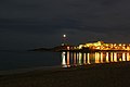 Lighthouse at night
 -
![Hormiga Island Beacon [es] (white)](//upload.wikimedia.org/wikipedia/commons/thumb/e/ec/Islas_Hormigas_-_Cabo_de_Palos.jpg/120px-Islas_Hormigas_-_Cabo_de_Palos.jpg) Hormiga Island Beacon (white)
Hormiga Island Beacon (white)
![Cape Palos Lighthouse [es]](/File:Faro_Cabo_de_Palos.jpg)

![Hormiga Island Beacon [es] (white)](/File:Islas_Hormigas_-_Cabo_de_Palos.jpg)
External links
- (in Spanish) Guía Turística de Cabo de Palos
- (in Spanish) Los cartagineses en Turdetania y Oretania
- (in Spanish) Toponimia romana y de romanización en Murcia

37°38′10″N 0°41′24″W / 37.636°N 0.690°W
This Spain location article is a stub. You can help Wikipedia by expanding it. |