
Castles of Manderscheid

Near the
Oberburg

The Oberburg or "Upper Castle" is located on a hilltop that was levelled in order to construct the castle. It had, as can still be seen from the ruins, an almost triangular
The place name of Manderscheid is first recorded in a deed of gift by
Today: the ruins of the Oberburg were thoroughly renovated in 1921 by the municipality of Manderscheid, on whose land it stands, and it is open to the public.
Niederburg
-
 Niederburg: 1576 engraving by Frans Hogenberg
 -
 Ruins of the Niederburg
 -
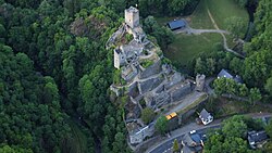 Niederburg, 2015 aerial photograph
 -
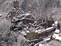 The Niederburg in winter


Today: the ruins of the Niederburg have been owned since 1899 by the Eifel Club and the club has slowly, but continually, restored them. They may be visited daily during the summer months. Guided group tours are also possible on request. The castle may also be booked for private events such as weddings. On the last weekend in August every year there is a medieval festival at the castle and the adjacent jousting field which receives about 15,000 visitors.[2]
References
- ^ c.f. Gesta Alberonis auctore Balderico, in: MGH SS VIII, p. 253
- ^ Historisches Burgenfest Manderscheid
External links
- Entry on Niederburg Manderscheid in European Castles Institute
- Entry on Oberburg Manderscheid in European Castles Institute
- Website of the Niederburg
- Artist's impression by Wolfgang Braun
- 1625 illustration by Daniel Meisner: Manderscheidt; Múß, ein bitters Kraútt (Digitized)