
Cataractes District
Cataractes District | |
|---|---|
District | |
 Cataractes district of Kongo-Central province (2014) | |
| Coordinates: 5°15′S 14°52′E / 5.25°S 14.87°E | |
| Country | Democratic Republic of the Congo |
| Province | Kongo Central |
| District | Cataractes |
Cataractes District was a district located in the Kongo Central province, in the Democratic Republic of the Congo. It dated back to the days of the Congo Free State and the Belgian Congo.
History
Article 3 of the decree of 16 April 1887 provided for the Congo Free State to be divided into administrative districts headed by district commissioners, assisted by one or more deputies. The decree of 1 August 1888 divided the Congo Free State into eleven districts, of which the first five were in the lower Congo region, including Cataractes District with its headquarters at
Cataractes District is shown on a map of the colony in 1897 as bordered by French possessions to the north and Portuguese possessions to the south. It lay between
In 1933 the original four provinces of the Belgian Congo were reorganized into six provinces, named after their capitals, and the central government assumed more control.[5]
Maps
-
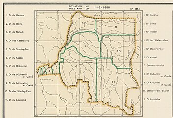 Districts of the Congo Free State in 1888. The small western districts were Banana, Boma, Matadi and Cataractes
 -
 Districts of the Congo Free State in 1895.
 -
 1910 districts
 -
 1933 districts. The greater part of Bas Congo district later became Cataracts District.


See also
- Districts of the Congo Free State
- Districts of the Belgian Congo
- Districts of the Democratic Republic of the Congo
References
- ^ Omasombo Tshonda 2014, p. 211.
- ^ Omasombo Tshonda 2015, p. 16.
- ^ a b Atlas général du Congo.
- ^ Lemarchand 1964, p. 62.
- ^ Bruneau 2009, p. 8.
- ^ Lemarchand 1964, p. 64.
- ^ Brass 2015, p. 243.
- ^ Brass 2015, p. 254.
Sources
- Atlas général du Congo / Algemene atlas van Congo (in French and Dutch), Belgium: Institut Royal Colonial Belge, 1948–1963, OCLC 681334449
- Brass, William (8 December 2015), Demography of Tropical Africa, Princeton University Press, ISBN 978-1-4008-7714-0, retrieved 20 August 2020
- Bruneau, Jean-Claude (30 June 2009), "Les nouvelles provinces de la République Démocratique du Congo : construction territoriale et ethnicités", L'Espace Politique, 7 (2009–1), , retrieved 2020-08-08
- Lemarchand, René (1964), Political Awakening in the Belgian Congo, University of California Press, GGKEY:TQ2J84FWCXN, retrieved 19 August 2020
- Omasombo Tshonda, Jean (2014), Bas-Uele, Musée royal de l’Afrique centrale, ISBN 978-9-4916-1586-3, retrieved 2020-08-26
- Omasombo Tshonda, Jean (2015), Mongala : Jonction des territoires et bastion d'une identité supra-ethnique (PDF), Musée royal de l’Afrique centrale, ISBN 978-9-4922-4416-1, retrieved 2020-08-18
This Democratic Republic of the Congo location article is a stub. You can help Wikipedia by expanding it. |