
Cataraqui River
This article includes a list of general references, but it lacks sufficient corresponding inline citations. (March 2013) |
The Cataraqui River (/ˌkætəˈrɒkweɪ/ KAT-ə-ROK-way) forms the lower portion of the Rideau Canal and drains into Lake Ontario at Kingston, Ontario. The name is taken from the original name for Kingston, Ontario; its exact meaning, however, is undetermined. Early maps showed several name variations including the Great Cataraqui River and Grand River Cataraquay. The river was once called Riviere de Frontenac, or Frontenac River.[1] The alternate spelling "Cadaraqui" also appears in some historic texts.[2]
Prior to the Rideau Canal being built (1826 – 1832), the Cataraqui River had its headwaters in Dog and Loughborough lakes.[3] It was a meandering creek, a 1795 map (by surveyor Lewis Grant) noted "a great number of rapids and Carrying Places on this creek." This changed with the building of the Rideau Canal. The Superintending Engineer of the project, Lt. Colonel John By, used a slackwater construction technique, building dams to drown rapids. In the area of the Cataraqui Creek from Upper Brewers to Kingston Mills he had the forests cut down to form a straight channel (this work is visible in the Burrowes paintings of Brewer's Lower Mill shown below). The area was then flooded in late 1831/early 1832 with the completion of canal dams at Kingston Mills, Lower Brewers and Upper Brewers.
Today the watershed of the Cataraqui River includes lakes south of the watershed divide at
When the Rideau Canal was built, Haskins' dam at Morton was enlarged and a new dam was built at Upper Brewers. Those two dams (managed today by Parks Canada) created Whitefish Lake, Little Cranberry Lake and much expanded Cranberry and Dog lakes. Most of the flow from what was previously the White Fish River watershed now flows down the Cataraqui River.
The Cataraqui Region Conservation Authority administers water management concerns within the Cataraqui River watershed.
-
 The lock at Lower Brewers nearing completion in 1831 by Thomas Burrowes
 -
 Brewer's Lower Mill - view down the Cataraqui Creek and clearing made for the Rideau Canal, 1829 by Thomas Burrowes
 -
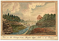 View on the Cataraqui Creek, Brewer's Upper Mills in the background, 1830 by Thomas Burrowes


See also
- List of Ontario rivers
- La Salle Causeway
- Waaban Crossing
- Belle Island
References
- ISBN 0-921341-06-7. p. 14
- ^ Smith, H. P. (Henry Perry); Mason (D. ) & Company (Syracuse, N. Y. ) (1885). History of Broome County : with illustrations and biographical sketches of some of its prominent men and pioneers. Allen County Public Library Genealogy Center. Syracuse, N.Y., D. Mason.
- ISBN 978-0-9780751-1-8