
Chaffey Dam
| Chaffey Dam | |
|---|---|
Flood mitigation, irrigation, water supply, and water conservation | |
| Status | Operational |
| Construction began | August 1976 |
| Opening date | September 1979 |
| Owner(s) | State Water Corporation |
| Dam and spillways | |
| Type of dam | Embankment dam |
| Impounds | Peel River |
| Height | 55.8 metres (183 ft) |
| Length | 430 metres (1,410 ft) |
| Width (crest) | 8 metres (26 ft) |
| Width (base) | 195 metres (640 ft) |
| Dam volume | 1,413 cubic metres (49,900 cu ft) |
| Spillways | 1 |
| Spillway type | Morning glory |
| Spillway capacity | 903 cubic metres per second (31,900 cu ft/s) |
| Reservoir | |
| Total capacity | 102,868 megalitres (3,632.7×106 cu ft) |
| Catchment area | 420 square kilometres (160 sq mi) |
| Surface area | 542 hectares (1,340 acres) |
| Maximum water depth | 30 metres (98 ft) |
| Normal elevation | 518 metres (1,699 ft) AHD |
| Website Chaffey Dam at www.waternsw.com.au | |
Chaffey Dam is a minor ungated
.Location and features
Commenced in August 1976 and completed in September 1979, the Chaffey Dam is a minor dam on the Peel River, a tributary of the Namoi River, approximately 16 kilometres (9.9 mi) north of Nundle and 44 kilometres (27 mi) south-east of Tawmorth.[1] Water from the dam is released directly into the Peel River which is used by irrigators downstream of the dam, and for water supply of the city of Tamworth.[2]
The dam wall comprises 1,413 cubic metres (49,900 cu ft) of rock fill is 55.8 metres (183 ft) high and is 430 metres (1,410 ft) long. The maximum water depth is 30 metres (98 ft) and at 100% capacity the dam wall holds back 62,830 megalitres (2,219×106 cu ft) of water at 518 metres (1,699 ft) AHD. The surface area of the reservoir is 542 hectares (1,340 acres) and the catchment area is 420 square kilometres (160 sq mi).
The dam uses an unusual concrete morning glory bell-shaped uncontrolled spillway which is capable of discharging 903 cubic metres per second (31,900 cu ft/s).[2][3][4] The spillway measures 25.81 metres (84.7 ft) in diameter and tapers down to 7.72 metres (25.3 ft). The spillway tower is 35.1 metres (115 ft) high.[citation needed]
Chaffey Dam provides valuable public recreation including swimming, sailing, boating and fishing.[2]
Upgrade of facilities
An A$13 million upgrade of Chaffey Dam commenced during 2010 that involved the construction of a 35 metres (115 ft) auxiliary spillway with release plug, funded by the
Etymology
The dam is named in honor of Frank Chaffey,[1] who represented Tamworth in the New South Wales Legislative Assembly between 1913 and 1940, and his son, [[Bill Nye |Bill]],[1] who represented the same seat between 1940 and 1973.
Gallery
-
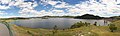 Chaffey Dam as viewed from lookout on Nundle Road, 2008.
 -
 Lower section of wall, April 2018.
 -
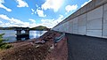
 Spillway post upgrade, April 2018.

See also
References
- ^ a b c "Chaffey Dam". Geographical Names Register (GNR) of NSW. Geographical Names Board of New South Wales. Retrieved 14 April 2013.
- ^ a b c "Chaffey Dam" (PDF). State Water Corporation. 2009. Archived from the original (PDF brochure) on 20 March 2012. Retrieved 14 April 2013.
- ^ "Chaffey Dam". Water delivery: Dams. State Water Corporation. Archived from the original on 10 April 2013. Retrieved 14 April 2013.
- ^ "Register of Large Dams in Australia". Dams information. The Australian National Committee on Large Dams Incorporated. 2010. Archived from the original (Excel (requires download)) on 12 December 2013. Retrieved 22 April 2013.
- ^ "Chaffey upgrade". Projects: Dam safety upgrades. State Water Corporation. Archived from the original on 10 April 2013. Retrieved 14 April 2013.
- ^ "Chaffey Dam augmentation". Projects: Dam safety upgrades. State Water Corporation. Archived from the original on 10 April 2013. Retrieved 14 April 2013.
External links
- "Namoi River catchment" (map). Office of Environment and Heritage. Government of New South Wales.
- "Information about Chaffey Dam". Your information guide to Northern NSW. July 2008. Retrieved 14 April 2013.