
Chausuyama Kofun (Ōtsu)
茶臼山古墳 | |
Ōtsu, Shiga, Japan | |
| Region | Kansai region |
|---|---|
| Coordinates | 34°59′25.17″N 135°53′2.45″E / 34.9903250°N 135.8840139°E ***Suspect** |
| Type | Kofun |
| History | |
| Founded | 4th-5th century AD |
| Periods | Kofun period |
| Site notes | |
| Public access | Yes (no public facilities) |
The Chausuyama Kofun (茶臼山古墳) is a
Ōtsu, Shiga in the Kansai region of Japan. The tumulus was designated a National Historic Site of Japan in 1921.[1]
With a total length of 122 meters, it is the third largest kofun in Shiga Prefecture.
Overview
The Chausuyama Kofun is located on a hill on the southern shore of
circular-type (empun (円墳)) which is included in the National Historic Site designation.[2]
There is a long tradition connecting this kofun to the family of
Prince Ōama in the Jinshin War.[2]
The tumulus is located about a 15-minute walk from
Ishiyama Sakamoto Line.[2]
- Overall length
- 122 meters
- Posterior circular portion
- 70 meter diameter x 8 meter high
- "Neck" portion
- 56 meters wide
- Anterior rectangular portion
- 58 meters wide x 60 meters long
Gallery
-
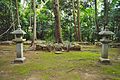 posterior portion
 -
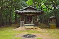 Akiba Shrine located on the saddle of the tumulus
 -
 Anterior portion
,_kouenbu.jpg)
,_Akiba-jinja.jpg)
,_zenpoubu.jpg)
See also
References
- ^ "茶臼山古墳・小茶臼山古墳" [Chausuyama Kofun / Kochausuyama] (in Japanese). Agency for Cultural Affairs. Retrieved August 20, 2020.
- ^ ISBN 4311750404.(in Japanese)
External links
Wikimedia Commons has media related to Chausuyama Kofun (Otsu).
- Shiga Prefecture Department of Education (in Japanese)