
Colwyn, Pennsylvania
Colwyn, Pennsylvania | |
|---|---|
EDT) | |
| Area code(s) | 610 |
| FIPS code | 42-15432 |
| Website | www |
Colwyn is a borough in Delaware County, Pennsylvania, United States. The population was 2,546 at the 2010 census.[3]
Geography
Colwyn is located along the eastern border of Delaware County at 39°54′47″N 75°15′12″W / 39.91306°N 75.25333°W (39.913062, -75.253409),
According to the U.S. Census Bureau, the borough has a total area of 0.26 square miles (0.67 km2), all land.[3]
Transportation

As of 2008, there were 3.96 miles (6.37 km) of public roads in Collingdale, all of which were maintained by the borough.[5]
No numbered highways serve Colwyn directly. Fourth Street is the longest street within borough limits.
The
Demographics
| Census | Pop. | Note | %± |
|---|---|---|---|
| 1900 | 1,226 | — | |
| 1910 | 1,584 | 29.2% | |
| 1920 | 1,859 | 17.4% | |
| 1930 | 2,064 | 11.0% | |
| 1940 | 2,202 | 6.7% | |
| 1950 | 2,143 | −2.7% | |
| 1960 | 3,074 | 43.4% | |
| 1970 | 3,169 | 3.1% | |
| 1980 | 2,841 | −10.4% | |
| 1990 | 2,613 | −8.0% | |
| 2000 | 2,453 | −6.1% | |
| 2010 | 2,546 | 3.8% | |
| 2020 | 2,474 | −2.8% | |
| [6][2] | |||
As of 2010 census, the racial makeup of the borough was 15.9%
Budgetary disarray
The borough government is in financial difficulty[when?]. In May 2015, it was declared to be "financially distressed" by the state. With an annual budget of about two million dollars, the borough is more than one million dollars in debt.
The local district attorney has seized[when?] financial records, although at least some from 2011, 2012, and 2013 cannot be accounted for.[8]
The local tax rate is very high[
Education
William Penn School District serves Colwyn.[10] The district was created in 1972; prior to that year, Colwyn was in the Darby-Colwyn School District.[11]
- Colwyn Elementary School (K-6)
- Penn Wood Middle School (7-8) (Darby)
- Penn Wood High School, Cypress Street Campus (9-10) (Yeadon)
- Penn Wood High School, Green Ave Campus (11-12) (Lansdowne)
-
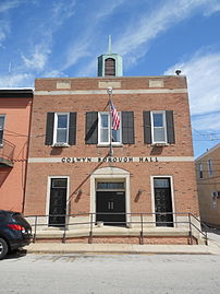 Borough Hall
 -
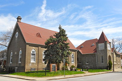 New Life Baptist Church


Notable person
- Alice Neel, visual artist
References
- ^ "ArcGIS REST Services Directory". United States Census Bureau. Retrieved October 12, 2022.
- ^ a b "Census Population API". United States Census Bureau. Retrieved Oct 12, 2022.
- ^ a b "Geographic Identifiers: 2010 Demographic Profile Data (G001): Colwyn borough, Pennsylvania". U.S. Census Bureau, American Factfinder. Archived from the original on February 13, 2020. Retrieved December 23, 2015.
- ^ "US Gazetteer files: 2010, 2000, and 1990". United States Census Bureau. 2011-02-12. Retrieved 2011-04-23.
- ^ "Colwyn Borough map" (PDF). PennDOT. Retrieved March 12, 2023.
- ^ "Census 2020".
- ^ [1][dead link]
- ^ McCabe, Caitlin (6 May 2015). "It's official: Troubled Delco town 'distressed'". The Philadelphia Inquirer. Retrieved 7 May 2015.
- ^ McCabe (25 May 2015). "Colwyn: Can this town be saved?". Philadelphia Daily News. Retrieved 26 May 2015.
- U.S. Census Bureau. Retrieved 2023-11-05.
- Newspapers.com.
External links
 | ||||
| Boroughs | ||||
| Townships | ||||
| CDPs | ||||
| Other communities |
| |||
| Ghost town | ||||
| Footnotes | ‡This populated place also has portions in an adjacent county or counties | |||
| ||||
| International | |
|---|---|
| National | |