
Conistone
| Conistone | |
|---|---|
North Yorkshire | |
| Ambulance | Yorkshire |
| UK Parliament | |
Conistone is a small village in the Craven district of North Yorkshire, England. It lies 3 miles (5 km) north of Grassington, 3 miles (5 km) south of Kettlewell and 12 miles (19 km) north of Skipton beside the River Wharfe, in Upper Wharfedale.[1]
History
Conistone is mentioned in the
The village is set in characteristic
The parish church, St Mary's Church, dates from the 11th or 12th century, and is a Grade II listed building.[7]
Conistone was historically in the large ancient parish of
Immediately to the east of the village lies Conistone Moor and Riggs Moor. The moorland here was known for its lead mines,[13] and also as being the furthest point in England from a road. Known by the Ordnance Survey as Pile of Stones, the point is on Riggs Moor and is found at 54°08′34″N 1°57′31″W / 54.1427°N 1.9585°W, SE03287183.[14]
Gallery
-
 St Mary's Church, Conistone, from the south-east
 -
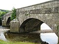 Stone arch bridge over Wharfe
 -
 Meadowsweet along B6160, toward Kilnsey
 -
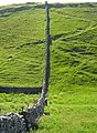 Wall across Dib
 -
 View down Dib from top, at Dales Way path
 -
 Conistone Dib


References
- ^ "Genuki: In 1822, the following places were in the Parish of Burnsall:, Yorkshire (West Riding)". www.genuki.org.uk. Retrieved 6 January 2020.
- ^ "Conistone | Domesday Book". opendomesday.org. Retrieved 6 January 2020.
- ISBN 0-19-869103-3.
- ^ Machell, Ben (22 May 2009). "Times Walks: Kettlewell and Conistone Moor, North Yorkshire". The Times. Retrieved 6 January 2020.
- ^ "Weekend Walk. Conistone Dib". The Yorkshire Post. 7 October 2017. Retrieved 6 January 2020.
- ^ Historic England. "Conistone Bridge over River Wharfe (Grade II) (1316801)". National Heritage List for England. Retrieved 6 January 2020.
- ^ Historic England. "Church of St Mary (1296267)". National Heritage List for England. Retrieved 21 June 2015.
- ^ "Places in the Parish of Burnsall in 1822". GENUKI. Retrieved 12 June 2013.
- ^ "Conistone With Kilnsey CP/Ch". Vision of Britain. Retrieved 12 June 2013.
- ^ UK Census (2001). "Local Area Report – Conistone with Kilnsey Parish (36UB020)". Nomis. Office for National Statistics. Retrieved 6 January 2020.
- Office for National Statistics. Retrieved 6 January 2020.
- ^ "2015 Population Estimates Parishes" (PDF). northyorks.gov.uk. December 2016. p. 10. Archived from the original (PDF) on 4 June 2022. Retrieved 6 January 2020.
- ^ "The Yorkshire Moors and Fells" (PDF). yorkshiredales.org.uk. p. 2. Retrieved 6 January 2020.
- ^ Hellen, Nicholas (26 May 2019). "The end of Britain's wilderness: nowhere is more than 6 miles from a road". The Sunday Times. Retrieved 6 January 2020.