
Customs Street
Hobson Street | |
| Major junctions | Queen Street |
|---|---|
| East end | Beach Road |
Customs Street is a street in the
History
.jpg)

Customs Street was built on reclaimed land.[4] Customs Street East began as a seawall between Point Stanley and Point Britomart across Commercial Bay, a former bay that used to exist on the Auckland waterfront. By 1859, reclamation work on Commercial Bay had begun, and Customs Street was created.[5] Much of the fill used to create the land along Customs Street was taken from Point Britomart, a former peninsula to the east of the street.[4]
The street was an important centre for trade in Auckland in the early 20th century due to its proximity to the Auckland waterfront and the railway station. Customs Street had a mix of warehouses, commercial offices of shipping companies found on the north, with shops and businesses found to the south.[4]
Demographics
The Quay Street-Customs Street statistical area covers 1.22 km2 (0.47 sq mi)[6] and had an estimated population of 2,300 as of June 2023,[7] with a population density of 1,885 people per km2.
| Year | Pop. | ±% p.a. |
|---|---|---|
| 2006 | 1,104 | — |
| 2013 | 2,256 | +10.75% |
| 2018 | 2,274 | +0.16% |
| Source: [8] | ||
Quay Street-Customs Street had a population of 2,274 at the
Ethnicities were 39.2% European/Pākehā, 4.4% Māori, 3.4% Pacific peoples, 50.0% Asian, and 7.5% other ethnicities. People may identify with more than one ethnicity.
The percentage of people born overseas was 69.1, compared with 27.1% nationally.
Although some people chose not to answer the census's question about religious affiliation, 46.2% had no religion, 26.1% were Christian, 0.1% had Māori religious beliefs, 9.2% were Hindu, 6.5% were Muslim, 4.0% were Buddhist and 3.4% had other religions.
Of those at least 15 years old, 924 (44.1%) people had a bachelor's or higher degree, and 93 (4.4%) people had no formal qualifications. The median income was $37,500, compared with $31,800 nationally. 510 people (24.4%) earned over $70,000 compared to 17.2% nationally. The employment status of those at least 15 was that 1,185 (56.6%) people were employed full-time, 288 (13.8%) were part-time, and 87 (4.2%) were unemployed.[8]
Notable locations
- The Aon Centre, also known as the AMP Tower
- Australis House
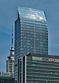
- Commercial Bay, a mixed-use office tower and retail development
- The former Customhouse, now the location of duty-free shopping centre T Galleria
- The Dilworth Building, a historic mixed-use building constructed in the 1920s.[9]
- Seascape, a residential skyscraper currently under construction
- Queens Arcade, a historic shopping arcade
- The United States Consulate General[4]
Gallery
-

-
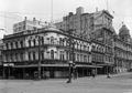 the Waitemata Hotel on the corner of Queen Street and Customs Street in 1927
 -
-
 Heritage buildings on Customs Street East
 -
 Excelsior Building, Stanbeth House and Masonic Club
 -
![Australis House and Arthur H. Nathan Warehouse (architect Arthur Pollard Wilson, who also designed Strand Arcade, Naval and Family Hotel,Northern Steam Ship Company Building and Isaacs’ Bonded Stores)[10]](//upload.wikimedia.org/wikipedia/commons/thumb/3/31/Australis_House_-_38297532852.jpg/120px-Australis_House_-_38297532852.jpg) Australis House and Arthur H. Nathan Warehouse (architect Arthur Pollard Wilson, who also designed Strand Arcade, Naval and Family Hotel,Northern Steam Ship Company Building and Isaacs’ Bonded Stores)[10]
Australis House and Arthur H. Nathan Warehouse (architect Arthur Pollard Wilson, who also designed Strand Arcade, Naval and Family Hotel,Northern Steam Ship Company Building and Isaacs’ Bonded Stores)[10] -
 The former Customhouse
 -
 Tepid Baths on Customs Street West
.jpg)


![Australis House and Arthur H. Nathan Warehouse (architect Arthur Pollard Wilson, who also designed Strand Arcade, Naval and Family Hotel,Northern Steam Ship Company Building and Isaacs’ Bonded Stores)[10]](/File:Australis_House_-_38297532852.jpg)

.jpg)
References
- ^ "Survey: SN146 Run: 63 Photo: 7". Retrolens. 22 April 1940.
- ^ "Survey: SN583 Run: 1917 Photo: 29". Retrolens. 19 September 1950.
- ^ "Survey: SN1052 Run: J Photo: 1". Retrolens. 14 April 1958.
- ^ Wikidata Q116870435.
- ^ "Auckland's waterfront and its changing face". Auckland City Libraries. Archived from the original on 18 October 2006.
- ^ "ArcGIS Web Application". statsnz.maps.arcgis.com. Retrieved 11 July 2022.
- ^ "Population estimate tables - NZ.Stat". Statistics New Zealand. Retrieved 25 October 2023.
- ^ a b "Statistical area 1 dataset for 2018 Census". Statistics New Zealand. March 2020. Quay Street-Customs Street (133300). 2018 Census place summary: Quay Street-Customs Street
- ^ "Dilworth Building". New Zealand Heritage List/Rārangi Kōrero. Heritage New Zealand. Retrieved 23 July 2013.
- ^ "Heritage Evaluation - Darby Building, 8-18 Darby Street, Auckland Central" (PDF). Auckland Council. May 2017.
External links
![]() Media related to Customs Street, Auckland at Wikimedia Commons
Media related to Customs Street, Auckland at Wikimedia Commons