
Daftah
Daftah
دفته | |
|---|---|
 Daftah location of Daftah | |
| Coordinates: 25°16′27″N 56°11′0″E / 25.27417°N 56.18333°E | |
| Country | |
| Emirate | Ras Al Khaimah |
| Elevation | 629 m (2,066 ft) |
Daftah (
.The village is located on the
Fujairah highway, which follows a route along the Wadi Ham (وادي حام). It is also located off the Sharjah-Khor Fakkan highway, constructed by contractor Halcrow.[1] The $1.6 billion road, opened in 2019, connects Daftah with Khor Fakkan through a series of five tunnels through the Hajar Mountains, passing the newly redeveloped village of Shis. These include the Al Sidra Tunnel, which at 2,700 metres, is the longest covered mountain tunnel in the Middle East.[2]
Although the village today is located along the roadside in a strip development, the old village of Daftah lies behind the new development, and was traditionally home to the Naqbiyin tribe.[3]
Gallery
-
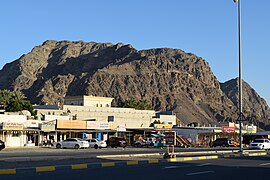 Daftah Mountain Valley Shops
 -
 The Daftah-Khor Fakkan Road under construction


References
- ^ "Sharjah Roads and Tunnels Project Hits Milestone". Construction Week.
- ^ "Video: New Sharjah-Khor Fakkan road opens". gulfnews.com. Retrieved 2020-10-21.
- )
| Cities |
|  |
|---|---|---|
| Settlements | ||
| Mountains |
| |
This United Arab Emirates location article is a stub. You can help Wikipedia by expanding it. |