
Darfur Dome
Meidob Hills, formed around 6.8 Ma.[1]
There are currently two competing theories concerning Darfur Dome’s formation. The conventional view is that magmatism is the product of a rising
Central African Fault Zone.[1][2] Evidence for a plume origin includes domal uplift, gravity anomalies, and low seismic velocity zones in the mantle,[1][2][3][4][5][6] though there is disagreement over whether these indicate a discreet, narrow plume under the Darfur region[1][2][3] or a broad superplume with conduits feeding several African hotspots.[4][5][6]
Recently, some scientists have argued for a tectonic origin in which lithospheric extension, asthenospheric shear, and small-scale convection have enabled passive melting of shallow source material.[7][8][9][10] This interpretation is supported by high seismic shear wave velocities which indicate shallow, cold downwellings[7] as well as normal heat-flow and low helium isotope ratios.[8][9]
-
 Deriba Caldera
 -
 Jebel MarraDeriba Lakes
 -
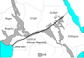 Central Africa showing CASZ.


Notes
13°5′0″N 24°20′0″E / 13.08333°N 24.33333°E
This tectonics article is a stub. You can help Wikipedia by expanding it. |
This Sudan location article is a stub. You can help Wikipedia by expanding it. |