
Dawson Valley (Theodore) railway line


The Dawson Valley Branch Railway was a railway line in
History
Revised plans were approved by
The
Abt rack section
The next stage to
After opening, three
Southwest extension
The discovery of
The
The transport of coal to Mount Morgan and for the Railways Department was a major contributor to the extended service.
The proposed
The service to Theodore was laborious. A mixed train arrived at 4.30am twice a week and departed at 7.30am. The journey to Mount Morgan took almost 8 hours. A weekly rail motor service introduced in 1952 reduced the journey to Rockhampton to some 6 ½ hours.
Bypassing the rack
The rack railway section near Mount Morgan was closed in 1952 after a conventional line was built to bypass it, with grades of 1 in 50 (2%). This occurred because the rack locomotives were due for replacement and the rack section was becoming a bottleneck in the haulage of coal from Callide Coalfields.
In 1961 a new coal mine (now known as the Dawson mine) was opened south-east of the town of Moura. Initially coal was loaded at a siding at Kianga, 15 km south of Moura. In 1963 a 12 km line was built from Moura to the new mine. At that time the most powerful steam locomotive owned by QR known as the Beyer-Garratt could haul a 750-ton coal load.
Partial closure
Sections from Kabra to Mount Morgan and Wowan (69 km) and from Baralaba to Moura (47 km) were closed from 1 August 1987 and the lines were taken up, except for a short section at Mt Morgan.
Since 1968 Moura coal has been hauled to Gladstone via the Moura Short Line. When it opened, triple header diesel hauled trains took 4000 ton coal loads direct to Gladstone.
Route
| Distance from Rockhampton | Stations | Present locality | Coordinates | Altitude | Notes |
|---|---|---|---|---|---|
| 9 miles 74 chains (16.0 km) | Kabra
|
Kabra, Rockhampton Region | 23°28′08″S 150°23′41″E / 23.4689°S 150.3946°E | 91 feet (28 m) | Line branches from the |
| 13 miles 58 chains (22.1 km) | Boongary
|
Kabra | 23°31′11″S 150°24′25″E / 23.5196°S 150.4069°E | 221 feet (67 m) | [7][9][10] |
Callan
|
Kabra | 23°32′39″S 150°23′58″E / 23.5443°S 150.3994°E | 331 feet (101 m) | [7] | |
| 17 miles 1 chain (27.4 km) | Bundaleer
|
Bouldercombe | 23°33′08″S 150°22′53″E / 23.5521°S 150.3814°E | 448 feet (137 m) | [11] |
| 18 miles 56 chains (30.1 km) | Moonmera
|
Bouldercombe | 23°33′47″S 150°23′18″E / 23.5630°S 150.3882°E | 520 feet (160 m) | [7][9][10] |
| 22 miles 13 chains (35.7 km) | Moongan
|
Moongan | 23°36′23″S 150°23′49″E / 23.6064°S 150.3969°E | 893 feet (272 m) | [7][9][10] |
| 23 miles 7 chains (37.2 km) | Kirkhall
|
Baree | 23°37′08″S 150°23′29″E / 23.6188°S 150.3915°E | 824 feet (251 m) | [7][9][10] |
| 23 miles 47 chains (38.0 km) | Baree
|
Baree | 23°37′25″S 150°23′22″E / 23.6236°S 150.3895°E | 784 feet (239 m) | [7][9][10] |
| 24 miles 6 chains (38.7 km) | Walterhall
|
Mount Morgan | 23°37′49″S 150°23′15″E / 23.6302°S 150.3876°E | 761 feet (232 m) | [7][9][10] |
| 24 miles 57 chains (39.8 km) | Mount Morgan | Mount Morgan | 23°38′21″S 150°23′12″E / 23.6392°S 150.3867°E | 748 feet (228 m) | [7][9][10] |
| 25 miles 71 chains (41.7 km) | Talban
|
The Mine | 23°39′02″S 150°22′33″E / 23.6505°S 150.3759°E | 707 feet (215 m) | [7][9][10] |
| 26 miles 39 chains (42.6 km) | Kenbula
|
The Mine | 23°39′29″S 150°22′14″E / 23.6580°S 150.3706°E | 681 feet (208 m) | [7][9][10] |
| 27 miles 12 chains (43.7 km) | Ulogie
|
Trotter Creek | 23°40′21″S 150°22′14″E / 23.6725°S 150.3706°E | 671 feet (205 m) | Despite the name, Ulogie railway station is not in the present-day locality of Ulogie.[7][9][10] |
| 29 miles 20 chains (47.1 km) | Muranu
|
Trotter Creek | 23°41′06″S 150°21′16″E / 23.6849°S 150.3545°E | 614 feet (187 m) | [9][10] |
| 33 miles 77 chains (54.7 km) | Walmul
|
Walmul | 23°43′31″S 150°22′26″E / 23.7254°S 150.3740°E | 547 feet (167 m) | [7][9][10] |
| 37 miles 47 chains (60.5 km) | Konara
|
Oakey Creek / Wura | 23°46′04″S 150°21′17″E / 23.7679°S 150.3548°E | 506 feet (154 m) | [12][13][14] |
| 40 miles 39 chains (65.2 km) | Gelobera
|
Wura | 23°48′05″S 150°20′51″E / 23.8014°S 150.3476°E | 480 feet (150 m) | [12][13][14] |
| 42 miles 38 chains (68.4 km) | Wura
|
Wura | 23°48′49″S 150°19′19″E / 23.8135°S 150.3220°E | 453 feet (138 m) | [7][12][13] |
| 43 miles 32 chains (69.8 km) | Boogargan
|
Dululu, Shire of Banana | 23°48′44″S 150°18′30″E / 23.8123°S 150.3083°E | [7][13][15] | |
| 47 miles 23 chains (76.1 km) | Dululu
|
Dululu | 23°50′44″S 150°15′40″E / 23.8455°S 150.2612°E | 421 feet (128 m) | [7][13][12] |
| 50 miles 25 chains (81.0 km) | Littles Crossing
|
Dululu | 23°52′17″S 150°13′24″E / 23.8714°S 150.2232°E | 297 feet (91 m) | [16][17] |
| 53 miles 26 chains (85.8 km) | Wowan
|
Wowan | 23°54′21″S 150°11′53″E / 23.9057°S 150.1980°E | 368 feet (112 m) | [7][12][17] |
| 56 miles 76 chains (91.7 km) | Buneru
|
Wowan | 23°57′23″S 150°10′24″E / 23.9563°S 150.1733°E | 367 feet (112 m) | [7][12][17] |
| 58 miles 69 chains (94.7 km) | Cooneel
|
Wowan | 23°58′43″S 150°09′37″E / 23.9787°S 150.1603°E | 354 feet (108 m) | [7][12][17] |
| 61 miles 78 chains (99.7 km) | Muruguran
|
Wowan | 24°01′13″S 150°08′42″E / 24.0204°S 150.1450°E | 355 feet (108 m) | [7][17][18] |
| 68 miles 43 chains (110.3 km) | Rannes
|
Goovigen | 24°06′13″S 150°07′06″E / 24.1035°S 150.1182°E | 327 feet (100 m) | Callide Valley railway line branches off at Rannes.[7][17][18] |
| 78 miles 18 chains (125.9 km) | Kokotungo
|
Kokotungo | 24°08′14″S 149°59′49″E / 24.1373°S 149.9969°E | 335 feet (102 m) | [7][17][19] |
| 83 miles 50 chains (134.6 km) | Kooemba
|
Kokotungo | 24°09′51″S 149°55′21″E / 24.1642°S 149.9225°E | 347 feet (106 m) | [7][17][19] |
| 86 miles 72 chains (139.9 km) | Kalewa
|
Kokotungo | 24°09′42″S 149°52′23″E / 24.1616°S 149.8731°E | 281 feet (86 m) | [7][17][19] |
| 91 miles 6 chains (146.6 km) | Baralaba
|
Baralaba | 24°10′42″S 149°48′49″E / 24.1782°S 149.8137°E | 307 feet (94 m) | [7][17][19] |
| Spur to State Coal Mine[19] | |||||
| 98 miles 8 chains (157.9 km) | Wonbindi
|
Baralaba | 24°16′16″S 149°50′51″E / 24.2712°S 149.8474°E | 289 feet (88 m) | [7][19][20] |
| 101 miles 0 chains (162.5 km) | Harcourt
|
Baralaba | 24°18′48″S 149°50′51″E / 24.3134°S 149.8476°E | 298 feet (91 m) | [7][19][20] |
| 105 miles 70 chains (170.4 km) | Bindaree
|
Baralaba | 24°22′45″S 149°51′52″E / 24.3793°S 149.8645°E | 314 feet (96 m) | [7][19][21] |
| 109 miles 40 chains (176.2 km) | Mungi
|
Moura | 24°25′51″S 149°52′21″E / 24.4307°S 149.8724°E | 323 feet (98 m) | [7][19][21] |
| 115 miles 6 chains (185.2 km) | Kinma
|
Moura | 24°30′20″S 149°54′33″E / 24.5056°S 149.9092°E | 433 feet (132 m) | [7][19][21] |
| 121 miles 17 chains (195.1 km) | Moura
|
Moura | 24°34′03″S 149°58′34″E / 24.5676°S 149.9760°E | 462 feet (141 m) | Moura is still an operational station, as it is also on the Moura railway line.[7][19][21] |
| 124 miles 53 chains (200.6 km) | Gibihi
|
Kianga | 24°36′55″S 149°59′52″E / 24.6153°S 149.9977°E | 484 feet (148 m) | [7][19][22] |
| 130 miles 40 chains (210.0 km) | Kianga
|
Kianga | 24°41′42″S 150°00′45″E / 24.6949°S 150.0124°E | 514 feet (157 m) | [7][22] |
| 136 miles 14 chains (219.2 km) | Nipan
|
Kianga | 24°46′27″S 150°01′18″E / 24.7742°S 150.0217°E | 436 feet (133 m) | [7][22] |
| 140 miles 25 chains (225.8 km) | Willawa
|
Kianga | 24°49′57″S 150°02′01″E / 24.8324°S 150.0337°E | 515 feet (157 m) | [7][22] |
| 142 miles 50 chains (229.5 km) | Kaloola
|
Kianga | 24°50′55″S 150°03′45″E / 24.8487°S 150.0624°E | 531 feet (162 m) | [7][22] |
| 146 miles 72 chains (236.4 km) | Goolara
|
Lonesome Creek | 24°54′25″S 150°04′50″E / 24.9069°S 150.0805°E | 461 feet (141 m) | [7][22] |
| 149 miles 72 chains (241.2 km) | Theodore
|
Theodore | 24°56′57″S 150°04′55″E / 24.9491°S 150.0820°E | 461 feet (141 m) | [22] |
Gallery
-
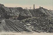 View of the Mt Morgan open cut mine, 1905
 -
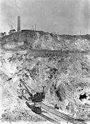 Rail mounted machinery in the Mt Morgan open cut mine, 1908
 -
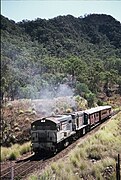 QR locos 1603 & 1634 climb the Razorback Range on the 'Last Train to Mt Morgan' tour, 1 August 1987
 -
 QR locos 1603 & 1634 south of Mt Morgan, 1 August 1987
 -
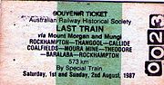 Rail Ticket for 'Last Train to Mt Morgan' tour 1987


See also
References
- ^ Kerr, J. (1990). Triumph of Narrow Gauge. Boolarong Press.
- ^ Knowles, J.W. (1982). The Mount Morgan Rack Railway. ANGRMS.
- ^ "THE MOUNT MORGAN RAILWAY". The Capricornian. Vol. 24, no. 49. Queensland, Australia. 3 December 1898. p. 10. Archived from the original on 28 July 2023. Retrieved 28 July 2023 – via National Library of Australia.
- The Brisbane Courier. National Library of Australia. 23 October 1922. p. 6. Archivedfrom the original on 24 January 2022. Retrieved 6 June 2014.
- ^ "DAWSON VALLEY". The Central Queensland Herald. Rockhampton, Qld.: National Library of Australia. 1 June 1933. p. 42. Archived from the original on 21 February 2021. Retrieved 6 June 2014.
- ^ "The Mount Morgan Railway". www.mountmorgan.org.au. Archived from the original on 28 May 2023. Retrieved 28 July 2023.
- ^ a b c d e f g h i j k l m n o p q r s t u v w x y z aa ab ac ad ae af ag ah ai aj ak "Railway stations and sidings – Queensland". Queensland Open Data. Queensland Government. 2 October 2020. Archived from the original on 5 October 2020. Retrieved 5 October 2020.
- ^ "Ridgelands" (Map). Queensland Government. 1946. Archived from the original on 24 January 2022. Retrieved 18 January 2022.
- ^ a b c d e f g h i j k l m "Queensland Two Mile series sheet 2m203" (Map). Queensland Government. 1952. Archived from the original on 24 January 2022. Retrieved 21 January 2022.
- ^ a b c d e f g h i j k l "Westwood" (Map). Queensland Government. 1942. Archived from the original on 18 January 2022. Retrieved 18 January 2022.
- ^ "Parish of Bouldercombe" (Map). Queensland Government. 1986. Archived from the original on 24 January 2022. Retrieved 22 January 2022.
- ^ a b c d e f g "Deeford" (Map). Queensland Government. 1944. Archived from the original on 18 January 2022. Retrieved 18 January 2022.
- ^ a b c d e "Queensland Two Mile series sheet 2m201" (Map). Queensland Government. 1954. Archived from the original on 3 May 2021. Retrieved 21 January 2022.
- ^ State of Queensland. Retrieved 22 January 2022.
- ^ "Boogargan – railway station in Shire of Banana (entry 3613)". Queensland Place Names. Queensland Government. Retrieved 19 January 2022.
- ^ "8950 Mount Morgan" (Map). Queensland Government. 1972. Archived from the original on 24 January 2022. Retrieved 23 January 2022.
- ^ a b c d e f g h i j "Queensland Two Mile series sheet 2m202" (Map). Queensland Government. 1954. Archived from the original on 24 January 2022. Retrieved 21 January 2022.
- ^ a b "Rannes" (Map). Queensland Government. 1944. Archived from the original on 18 January 2022. Retrieved 18 January 2022.
- ^ a b c d e f g h i j k l "Barabala" (Map). Queensland Government. 1944. Archived from the original on 18 January 2022. Retrieved 18 January 2022.
- ^ a b "Parish of Fairview" (Map). Queensland Government. 1971. Archived from the original on 24 January 2022. Retrieved 22 January 2022.
- ^ a b c d "Parish of Capayan" (Map). Queensland Government. 1978. Archived from the original on 24 January 2022. Retrieved 22 January 2022.
- ^ a b c d e f g "Theodore" (Map). Queensland Government. 1972. Archived from the original on 18 January 2022. Retrieved 18 January 2022.
External links
| |||||||||
| |||||||||
| |||||||||
| |||||||||