
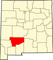
Derry, New Mexico
Derry | |
|---|---|
UTC-6 (MDT) | |
| Area code | 575 |
| GNIS feature ID | 888335[1] |
Derry is an
ZIP code 87933, which opened on August 11, 1911.[2][3] The town was named after Derry, Ireland, which was suggested by a former soldier.[4]
Education
Truth or Consequences Municipal Schools is the school district for the entire county.[5] Truth or Consequences Middle School and Hot Springs High School, both in Truth or Consequences, are the district's secondary schools.
References
- ^ a b U.S. Geological Survey Geographic Names Information System: Derry, New Mexico
- ^ "Postmaster Finder - Post Offices by ZIP Code". United States Postal Service. Archived from the original on February 9, 2004. Retrieved November 9, 2014.
- ^ United States Postal Service. "USPS - Look Up a ZIP Code". Retrieved November 9, 2014.
- ISBN 0826316891.
- U.S. Census Bureau. Retrieved July 12, 2022. - Text list
 | ||||
Villages | ||||
| CDPs | ||||
| Other communities | ||||
| Ghost towns | ||||
| ||||
This New Mexico state location article is a stub. You can help Wikipedia by expanding it. |