
Diemen
Diemen | |
|---|---|
Town and municipality | |
 A view of Diemen | |
|
UTC+2 (CEST) | |
| Postcode | 1110–1113 |
| Area code | 020 |
| Website | www |
Diemen (Dutch pronunciation: [ˈdimə(n)] ⓘ) is a town and municipality with a population of 31,334 in the province of North Holland, Netherlands. It is located approximately 6 km (3.7 mi) southeast of Amsterdam's city centre, within the Amsterdam metropolitan area.
Etymology
The name Diemen comes from the river Diem, which originates from die eme, meaning the water.[5]
Geography

Diemen is located in the province
.Three waterways cross the municipality: the Weespertrekvaart from west to south, the Amsterdam–Rhine Canal from north to east, and the river Diem from south to north. The river is the namesake of Diemen. The town can be divided into three neighbourhoods: Diemen Noord, Diemen Centrum, and Diemen Zuid.
Diemen Noord (English: North Diemen) is located on the south bank of the Amsterdam–Rhine Canal, which separates it from the Amsterdam neighbourhood IJburg, on the west bank of the river Diem, and on the north side of the Amsterdam–Zutphen railway. The area contains houses, a few of which are recreated late medieval houses, a minor shopping centre, and in the east a green area called Diemerpolder.
Diemen Centrum (English: Diemen Centre) extends from the Watergraafsmeer in the west, from which it is separated by the A10 motorway, all the way to the north-east of municipality with the rural area Overdiemerpolder, an electricity plant, and the green area Diemervijfhoek. The neighbourhood contains houses and apartment buildings, the largest shopping centre, and the town hall. The train station Diemen is located between Noord and Centrum.
Diemen Zuid (English: South Diemen) is located next to
Demographics
The municipality has a population of 25,915 and a population density of 2,161/km2 (5,600/sq mi).[6] 51,2% Dutch background, 48,8% No Dutch background
Government
The municipal government consists of the executive
After the 2010
The
Transportation

The motorways A1 (E231) and A9 pass through the municipality of Diemen, and the motorway A10 (Amsterdam ring) lies just outside the municipal border with Amsterdam.
Diemen has two train stations, Diemen on the Amsterdam–Zutphen railway and
Tram (line 19), bus and night bus services connect Diemen to Amsterdam and other towns in the area.
Bus service line 44 drives from Diemen North to the railway and metrostation
Metro line 53 stops at two stations (
Education
There are six
There are no secondary schools in Diemen. The nearest secondary schools are in Amsterdam and Weesp.[11]
There are two institutes of tertiary education in Diemen: the universities of applied sciences HBO Nederland and Inholland both have a location in Diemen Zuid.[12] The nearest universities are in Amsterdam.
Notable people

- Pieter Nieuwland (1764 in Diemermeer – 1794) a Dutch nautical scientist, chemist, mathematician and poet
- Rudi Falkenhagen (1933 in Diemen – 2005) a Dutch actor[13]
Sport
- Barend Bonneveld (1887 in Diemen – 1978) a Dutch heavyweight wrestler, competed at the 1912 and 1920 Summer Olympics
- Maarten Arens (born 1972 in Diemen) a Dutch judoka
- Junas Naciri (born 1973 in Diemen) a Dutch retired footballer with 336 club caps
- Levi Heimans (born 1985 in Diemen) a Dutch track cyclist, competed at the 2004 Summer Olympics
- Daley Blind (born 1990 in Diemen) a Dutch professional footballer playing for AFC Ajax with over 300 club caps and over 70 international caps
- Adam Maher (born 1993 in Diemen) a Dutch professional footballer with over 200 club caps
- Riejanne Markus (born 1994 in Diemen) a Dutch world champion cyclist
Gallery
-
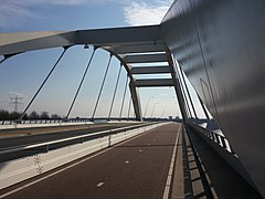 Diemen, panoramio
 -
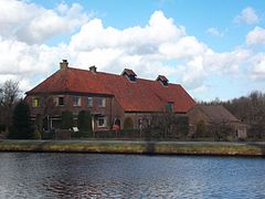 Stammerdijk 36 Driemond Diemen
 -
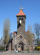 Sint-Petrusbandenkerk, Diemen
 -
 Weespertrekvaart
 -
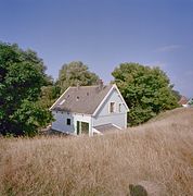 Fortwachterswoning - Diemen
.jpg)


References
- ^ "College van B&W – Wie is wie" (in Dutch). Municipality of Diemen. Archived from the original on 21 June 2015. Retrieved 21 June 2015.
- ^ "Kerncijfers wijken en buurten 2020" [Key figures for neighbourhoods 2020]. StatLine (in Dutch). CBS. 24 July 2020. Retrieved 19 September 2020.
- ^ "Postcodetool for 1111ZB". Actueel Hoogtebestand Nederland (in Dutch). Het Waterschapshuis. Retrieved 27 February 2014.
- ^ "Bevolkingsontwikkeling; regio per maand" [Population growth; regions per month]. CBS Statline (in Dutch). CBS. 1 January 2021. Retrieved 2 January 2022.
- ^ (in Dutch) Diemen, Vroegmiddelnederlands Woordenboek. Retrieved on 4 March 2014.
- ^ "Bevolkingsontwikkeling; regio per maand" [Population growth; regions per month]. CBS Statline (in Dutch). CBS. 23 December 2013. Retrieved 24 December 2013.
- Government of the Netherlands. 18 May 2015. Retrieved 2 April 2018.
- ^ "Groenlinks gaat met alle partijen in gesprek over coalitie". DiemerNieuws.nl. 28 March 2018. Retrieved 2 April 2018.
- ^ "Definitieve uitslag gemeenteraadsverkiezing 2018". Diemen Municipality. Retrieved 2 April 2018.
- ^ (in Dutch) Basisonderwijs, Lokaaltotaal.nl/Diemen. Retrieved on 2013-05-22.
- ^ (in Dutch) Voortgezet onderwijs, Lokaaltotaal.nl/Diemen. Retrieved on 2013-05-22.
- ^ (in Dutch) HBO, Lokaaltotaal.nl/Diemen. Retrieved on 2013-05-22.
- ^ IMDb Database retrieved 31 January 2020
External links
 Media related to Diemen at Wikimedia Commons
- (in Dutch) Official website
Places adjacent to Diemen | |
|---|---|

| International | |
|---|---|
| National | |
| Geographic | |