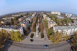
Dnestrovsc
You can help expand this article with text translated from the corresponding article in Russian. Click [show] for important translation instructions.
|
Dnestrovsc
Днестро́вск Дністро́вськ | |
|---|---|
Town | |
 | |
Location of Dnestrovsc in Moldova | |
| Coordinates: 46°37′20″N 29°54′38″E / 46.62222°N 29.91056°E | |
| Country (de jure) | |
| Country (de facto) | |
| Government | |
| • Mayor | Oleg Dovgopol |
| Elevation | 19 m (62 ft) |
| Population (2014) | |
| • Total | 10,436 |
| Climate | Cfb |
 | |
Dnestrovsc (
Transnistrian Moldovan Republic as a part of its Slobozia District
.
It is a company town which was founded in early Soviet times by the establishment of a large power plant, Moldavskaya GRES, today owned by Inter RAO UES.
At the 1989 census, Dnestrovsc had a population of 14,876. At the 2004 census it had ca. 11,200 inhabitants.
Notes
- political status is disputed. It considers itself to be an independent state, but this is not recognised by any UN member state. The Moldovangovernment and the international community consider Transnistria a part of Moldova's territory.


