
Dubai Creek
| Dubai Creek Khūr Dubay | |
|---|---|
 Abras (water taxis) on Dubai Creek | |
| Details | |
| Location | Dubai, United Arab Emirates |
| Length | Total 24 kilometres (15 mi) of which natural length is 14 kilometres (8.7 mi) |
| North end | Al Shindagha area |
| South end | Jumeirah Beach, Jumeirah area |
Dubai Creek (
In the 1950s, extensive development of the creek began, including dredging and construction of breakwaters. A number of bridges allow movement of vehicles across the creek while abras are used as taxis. The banks and route alongside the creek houses notable government, business and residential areas. A number of tourist locations and hotels are situated along the creek.
History

Historically, the creek divided the city into two main sections –

The importance of the creek as a site of commercial activity was a justification to introduce improvements to allow larger vessels to transit, as well as to facilitate loading and unloading activities. This led, in 1955, to a plan to develop the creek, which involved dredging shallow areas, building of
2000s
The
Route
Original route
The creek's initial inlet into mainland Dubai is along the
-
 Original route of Dubai Creek is highlighted in blue. The new extension is highlighted in red.
 -
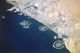 Coast of Dubai from the International Space Station. Dubai Creek is visible.
 -
 Dubai International Airport and Dubai Creek figure prominently in this photograph from the International Space Station.


Creek extensions
The creek has been extended by 13 km (8.1 mi) through Business Bay, Dubai Canal and through Jumeirah into the Arabian Gulf.

Landmarks

Including the most remarkable buildings alongside the Deira side of the Creek are the Deira Twin Towers, the old Dubai Creek Tower, Sheraton Dubai Creek, National Bank of Dubai, and Chamber of Commerce.[13] On the other side of Al Maktoum Bridge along Dubai Creek is Dubai Creek Park, one of the largest parks in Dubai.[14]
The creek is also home to the Dubai Creek Golf & Yacht Club, comprising an 18-hole tournament golf course, clubhouses, residential development and the Park Hyatt hotel.
Crossings
- Present crossings, in order from northwest to southeast
- Al Shindagha Tunnel
- Al Maktoum Bridge
- Dubai Smile" in the future)
- Al Garhoud Bridge
- Business Bay Crossing
- Infinity Bridge
- Future/planned crossings
- Dubai Smile (to replace the Floating Bridge)
- Sheikh Rashid bin Saeed Crossing (to link Al Jaddaf and Bur Dubai)
Ports and marinas


- Port Saeed
- Dubai Creek Harbour
- Al Jaddaf Marine Station
- Business Bay Marina
References
- ^ Gupte 2011, p. 76.
- ^ Hammad 2019, p. 101–102.
- S2CID 188648755. Retrieved 10 October 2021.
- ^ Dubai. T. Carter, L Dunston. Lonely Planet. 2006
- ^ Doing Business with the United Arab Emirates. Terterov, Marat. GMB Publishing Ltd. 2006
- ^ "Dubai - Modern History" (PDF). Archived from the original (PDF) on 4 October 2011. (47.0 KB). Department of Tourism and Commerce Marketing. Government of Dubai
- ^ Doing Business with the United Arab Emirates. Terterov, Marat. GMB Publishing Ltd. 2006
- ^ Ruling Shaikhs and Her Majesty's Government, 1960-1969. Joyce, Miriam. Routledge. 2003
- ^ a b Negotiating Change: The New Politics of the Middle East. Jones, Jeremy. IB Tauris. 2007
- ^ Derek Baldwin (27 September 2007). "Dubai Creek: It Just Got Longer". XPRESS.
- ^ Ahmed, Ashfaq (6 November 2009). "Floating Bridge will stay till 2014". Gulf News.
- ^ "Dubai Traffic, Architecture & Creek Bridges". ciio.unab.edu.co. Archived from the original on 23 February 2014. Retrieved 23 February 2014.
- ^ Dubai Creek Gigapixel Archived 16 April 2009 at the Wayback Machine. Highly detailed view of the Creek on a length of 3 km from Al Sabkha Rd to Chamber of Commerce.
- ^ "Dubai Creek Park" Archived 20 February 2016 at the Wayback Machine, capturedubai.com, 29 March 2015. Retrieved on 30 March 2015.
- Bibliography
- Hammad, Ahmed (June 2019). "Business Bay – Dubai Creek Extension -Construction Management, Challenges and Results. Part II – Project Details" (PDF). Journal of Engineering and Architecture. 7 (1): 100–109. S2CID 191180349.
- ISBN 9780670085170.
Further reading
- Ahmad Makia (April 2015) "Dubai Creek as an Island City-State: Free Zones, Canals, and City Doppelgängers." Avery Review:7
External links
25°15′21″N 55°19′0″E / 25.25583°N 55.31667°E