
Fair Haven, Vermont
Fair Haven, Vermont | ||
|---|---|---|
Town | ||
 Main Street | ||
 Located in Rutland County, Vermont | ||
 Location of Vermont with the U.S.A. | ||
| Coordinates: 43°36′00″N 73°16′06″W / 43.60000°N 73.26833°W | ||
| Country | United States | |
| State | Vermont | |
| County | Rutland | |
| Chartered | 1779 | |
| Communities | ||
| Government | ||
| • Manager | Joseph Gunter | |
| • Town Clerk | Dani Roberts | |
| • Selectboard | List of Selectboard members | |
| Area ZIP code | 05743 | |
| Area code | 802 | |
| Website | www.fairhavenvt.org | |
Fair Haven is a town in
History
Fair Haven was chartered on October 27, 1779, to Ebenezer Allen and 76 associates, and first settled the same year. The township originally included
The
-
 Prospect Street c. 1910
 -
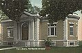 Free Library in 1914
 -
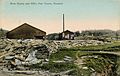 Slate quarry c. 1910


Demographics
| Census | Pop. | Note | %± |
|---|---|---|---|
| 1790 | 545 | — | |
| 1800 | 411 | −24.6% | |
| 1810 | 645 | 56.9% | |
| 1820 | 714 | 10.7% | |
| 1830 | 675 | −5.5% | |
| 1840 | 633 | −6.2% | |
| 1850 | 902 | 42.5% | |
| 1860 | 1,378 | 52.8% | |
| 1870 | 2,208 | 60.2% | |
| 1880 | 2,211 | 0.1% | |
| 1890 | 2,791 | 26.2% | |
| 1900 | 2,999 | 7.5% | |
| 1910 | 3,095 | 3.2% | |
| 1920 | 2,540 | −17.9% | |
| 1930 | 2,614 | 2.9% | |
| 1940 | 2,245 | −14.1% | |
| 1950 | 2,286 | 1.8% | |
| 1960 | 2,378 | 4.0% | |
| 1970 | 2,777 | 16.8% | |
| 1980 | 2,819 | 1.5% | |
| 1990 | 2,887 | 2.4% | |
| 2000 | 2,928 | 1.4% | |
| 2010 | 2,734 | −6.6% | |
| 2020 | 2,736 | 0.1% | |
| U.S. Decennial Census[7] | |||
As of the
Of the 1,282 total housing units, 1,135 (88.5%) of the houses were occupied and 147 (11.5%) were vacant. Of the occupied housing units, 755 (66.5%) were occupied by the owners (1,928 people), and 380 (33.5%) were rented (806 people). Of the 147 vacant housing units, 19 (12.9%) were for sale and 78 (53.1%) were for rent. The average number people per household was 2.41.
In the town, the population was spread out, with 1,320 (48.3%) males and 1,414 (51.7%) females. Out of the total population, there were 598 people under the age of 18 (21.9%), 193 (7.1%) between the ages 20–24, 265 (9.7%) within the ages of 25–34, 558 (20.41%) people who are between 35–49, 615 (22.5%) people are 50–64, and 425 (15.5%) people who are 65 and older.
As of 2000 Census, the median income for a household in the town was $34,313, and the median income for a family was $36,587. Males had a median income of $29,760 versus $21,406 for females. The
Geography
According to the United States Census Bureau, the town has a total area of 18.1 square miles (47 km2), of which 17.6 square miles (46 km2) is land and 0.5 square miles (1.3 km2), or 2.70%, is water. Fair Haven is drained by the Poultney River and Castleton River.
To the north, Fair Haven is bordered by
Government and politics
Fair Haven operates under a town meeting form of government with a town manager and a five-member Selectboard to supervise the local government. It has an annual operating budget of $2.9 million and 29 employees.[9]
The town lacks a mayor, but has a ceremonial mayoral election that is open to pets and animals with a paid submission to raise funds for the local elementary school. In an eighteen-candidate ballot on March 3, 2020, a Cavalier King Charles Spaniel named Murfee was elected as mayor to a one-year term.[10][11]
Transportation
The town is crossed by a freeway segment of
Neighboring cities and towns
Places adjacent to Fair Haven, Vermont | ||||||||||||||||
|---|---|---|---|---|---|---|---|---|---|---|---|---|---|---|---|---|
| ||||||||||||||||
Sites of interest
- Fair Haven Historical Society & Museum
- Ira C. Allen Mansion, the "Marble Mansion"
Fair Haven has a large town green, a fountain in the center of the green, and a gazebo at the south end of the green.
Notable people
- Erik Barnouw, historian of radio and television broadcasting
- Chittenden Lyon, US congressman from Kentucky
- Matthew Lyon, printer, farmer, soldier, founder of Fair Haven, and US congressman
- Joseph A. McNamara, U.S. Attorney for Vermont[12]
- Benjamin F. H. Witherell, jurist
- James Witherell, US congressman
See also
- Fair Haven (Amtrak station)
References
- ^ "2016 U.S. Gazetteer Files". United States Census Bureau.
- ^ "Census - Geography Profile: Fair Haven town, Rutland County, Vermont". United States Census Bureau. Retrieved December 29, 2021.
- ^ The Historic Architecture of Rutland County, Vermont State Register of Historic Places, pg. 121-140
- ^ Esther Munroe Swift, Vermont Place Names. pgs. 394-395
- ^ a b Austin J. Coolidge & John B. Mansfield, A History and Description of New England; Boston, Massachusetts 1859
- ^ 21 Stat. 72
- ^ "U.S. Decennial Census". United States Census Bureau. Retrieved May 16, 2015.
- ^ "U.S. Census website". United States Census Bureau. Retrieved January 31, 2008.
- ^ "Town Manager Position". Town of Fair Haven. Retrieved March 7, 2019.
- ^ Guzman, Francisco; Ahmed, Saeed (March 4, 2020). "And the winner of the mayoral race in Fair Haven, Vermont, is ... a therapy dog". CNN. Retrieved June 20, 2020.
- La República(in Spanish). March 5, 2020. Retrieved June 20, 2020.
- ^ Lamb, Wallace E. (1940). The Lake Champlain and Lake George Valleys. Vol. 3. New York, NY: The American Historical Company, Inc. pp. 259–260.
Further reading
External links
| City |  | |
|---|---|---|
| Towns | ||
Village | ||
| CDPs | ||
| Other communities | ||
| ||
| International | |
|---|---|
| National | |