
Farmers' High School
Farmers' High School | |
 | |
  | |
| Location | College Ave. and Atherton St., State College, Pennsylvania |
|---|---|
| Coordinates | 40°47′47″N 77°51′46″W / 40.79639°N 77.86278°W |
| Area | 82 acres (33 ha) |
| Built | 1855 |
| Architect | Multiple |
| Architectural style | Classical Revival, Colonial Revival, Other, Georgian Revival |
| NRHP reference No. | 81000538[1] |
| Added to NRHP | September 11, 1981 |
Farmers' High School is a national
Georgian Revival. A focal point of the district is the Nittany Lion Shrine (1942).[2]
It was added to the National Register of Historic Places in 1981.[1]
Gallery
-
 Old Main c. 1855
 -
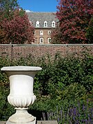
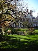 Former President's house.
 -
 Irvin residence hall in West Halls.
 -
 The Lion Shrine at Penn State.
 -
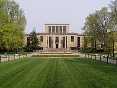 Pattee Library and mall at Penn State.


References
- ^ a b "National Register Information System". National Register of Historic Places. National Park Service. July 9, 2010.
- ^ "National Historic Landmarks & National Register of Historic Places in Pennsylvania". CRGIS: Cultural Resources Geographic Information System. Archived from the original (Searchable database) on September 14, 2005. Retrieved November 6, 2011. Note: This includes The Historic Registration Project (August 1980). "National Register of Historic Places Inventory Nomination Form: Farmers' High School" (PDF). Retrieved November 5, 2011.

| International | |
|---|---|
| National | |