
File:Circuit de la Sarthe track map.svg

Size of this PNG preview of this SVG file: 800 × 552 pixels. Other resolutions: 320 × 221 pixels | 640 × 442 pixels | 1,024 × 707 pixels | 1,280 × 884 pixels | 2,560 × 1,767 pixels | 1,424 × 983 pixels.
Original file (SVG file, nominally 1,424 × 983 pixels, file size: 83 KB)
| This is a file from the Wikimedia Commons. Information from its description page there is shown below. Commons is a freely licensed media file repository. You can help. |
Summary
| Description |
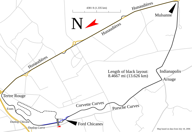
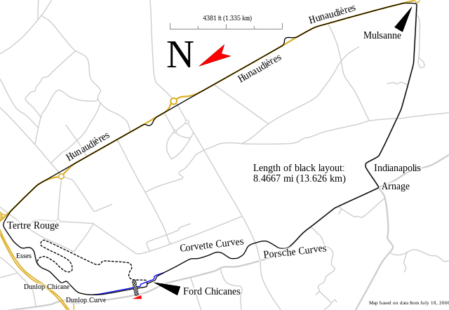
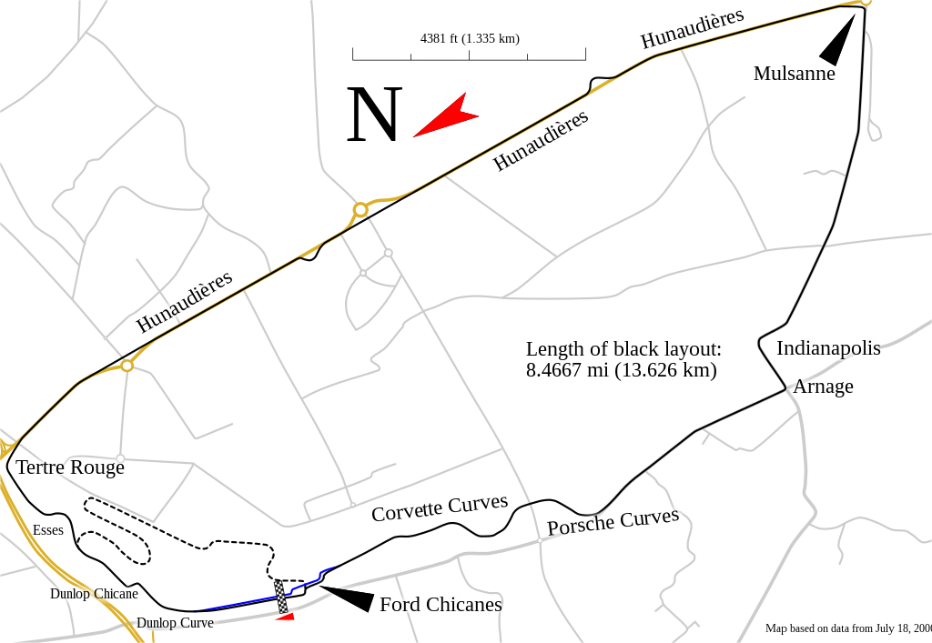
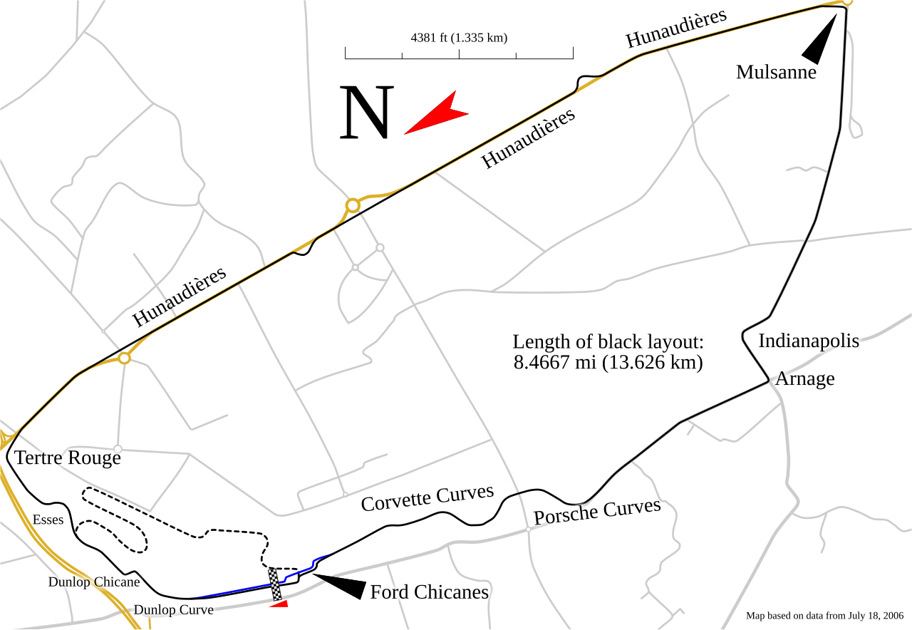
English: Track map for use with Circuit de la Sarthe |
| Date | |
| Source | Own work |
| Author | Will Pittenger |
| Other versions |
Derivative works of this file: Circuito de la Sarthe.svg
|


This W3C-unspecified vector image was created with Inkscape .
| Camera location | | View this and other nearby images on: OpenStreetMap |
|---|
Licensing
I, the copyright holder of this work, hereby publish it under the following license:
This file is licensed under the Creative Commons Attribution-Share Alike 3.0 Unported license.
- You are free:
- to share – to copy, distribute and transmit the work
- to remix – to adapt the work
- Under the following conditions:
- attribution – You must give appropriate credit, provide a link to the license, and indicate if changes were made. You may do so in any reasonable manner, but not in any way that suggests the licensor endorses you or your use.
- share alike – If you remix, transform, or build upon the material, you must distribute your contributions under the same or compatible license as the original.
File history
Click on a date/time to view the file as it appeared at that time.
| Date/Time | Thumbnail | Dimensions | User | Comment | |
|---|---|---|---|---|---|
| current | 21:53, 20 January 2018 | | 1,424 × 983 (83 KB) | OldLion | correction curves |
| 13:22, 20 January 2018 |  | 1,424 × 983 (83 KB) | OldLion | correct nom | |
| 04:57, 12 June 2011 |  | 1,424 × 983 (83 KB) | DagErlingSmørgrav | Correct several spelling mistakes. | |
| 01:11, 20 January 2010 |  | 1,424 × 983 (83 KB) | Will Pittenger | {{Information |Description={{en|1=Track map for use with w:Circuit de la Sarthe}} |Source={{own}} |Author=Will Pittenger |Date=2009-01-19 |Permission= |other_versions=<gallery>Circuit de la sarthe rev12 enlabels.svg|Circuit de |
File usage
The following pages on the English Wikipedia use this file (pages on other projects are not listed):
- 2002 24 Hours of Le Mans
- 2003 24 Hours of Le Mans
- 2004 24 Hours of Le Mans
- 2005 24 Hours of Le Mans
- 2006 24 Hours of Le Mans
- 2007 24 Hours of Le Mans
- 2008 24 Hours of Le Mans
- 2009 24 Hours of Le Mans
- 2010 24 Hours of Le Mans
- 2012 24 Hours of Le Mans
- 2013 24 Hours of Le Mans
- 2014 24 Hours of Le Mans
- 2015 24 Hours of Le Mans
- 2016 24 Hours of Le Mans
- 2016 Road to Le Mans
- 2017 24 Hours of Le Mans
- 2018 24 Hours of Le Mans
- 2019 24 Hours of Le Mans
- 2019 Road to Le Mans
- 2020 24 Hours of Le Mans
- 2020 24 Hours of Le Mans Virtual
- 2020 Road to Le Mans
- 2021 24 Hours of Le Mans
- 2021 Road to Le Mans
- 2022 24 Hours of Le Mans
- 2022 24 Hours of Le Mans Virtual
- 2022 Road to Le Mans
- 2023 24 Hours of Le Mans
- 2023 Road to Le Mans
- 2024 24 Hours of Le Mans
- 24 Hours of Le Mans
- Circuit de la Sarthe
- List of 24 Hours of Le Mans fatalities
- Mulsanne Straight
- Road to Le Mans
- User:FearfulWarpII/sandbox
- User:Reshadp/Template:Infobox WEC race
- User:Reshadp/Template:Infobox WEC race/doc
- User:Reshadp/WEC race test
- User:SmackJam/sandbox/2020 AXA 4 Hours of Le Mans
- User:SmackJam/sandbox/4 Hours of Le Mans
- Template:Infobox WEC race
- Template:Infobox WEC race/doc
Global file usage
The following other wikis use this file:
- Usage on ar.wikipedia.org
- Usage on ast.wikipedia.org
- Usage on az.wikipedia.org
- Usage on bg.wikipedia.org
- Usage on br.wikipedia.org
- Usage on cs.wikipedia.org
- Usage on da.wikipedia.org
- Usage on de.wikipedia.org
- Usage on el.wikipedia.org
- Usage on en.wikiversity.org
- Usage on en.wikivoyage.org
- Usage on eo.wikipedia.org
- Usage on es.wikipedia.org
- 24 Horas de Le Mans 2012
- 24 Horas de Le Mans 2013
- 24 Horas de Le Mans 2014
- 24 Horas de Le Mans 2017
- 24 Horas de Le Mans 2018
- 24 Horas de Le Mans 2019
- Mulsanne Straight
- 24 Horas de Le Mans 2015
- 24 Horas de Le Mans 2016
- 24 Horas de Le Mans 2020
- 24 Horas de Le Mans 2021
- 24 Horas de Le Mans 2022
- 24 Horas de Le Mans 2023
- Usage on eu.wikipedia.org
- Usage on fa.wikipedia.org
- Usage on fr.wikipedia.org
- Usage on gl.wikipedia.org
- Usage on gl.wiktionary.org
- Usage on he.wikipedia.org
- Usage on hu.wikipedia.org
- Usage on id.wikipedia.org
- Usage on it.wikipedia.org
View more global usage of this file.