
File:EAST FRONT FROM NORTHEAST - Pennsylvania Academy of the Fine Arts, Broad and Cherry Streets, Philadelphia, Philadelphia County, PA HABS PA,51-PHILA,340-2.tif

Size of this JPG preview of this TIF file: 800 × 577 pixels. Other resolutions: 320 × 231 pixels | 640 × 462 pixels | 1,024 × 739 pixels | 1,280 × 923 pixels | 2,560 × 1,846 pixels | 5,000 × 3,606 pixels.
Original file (5,000 × 3,606 pixels, file size: 17.2 MB, MIME type: image/tiff)
| This is a file from the Wikimedia Commons. Information from its description page there is shown below. Commons is a freely licensed media file repository. You can help. |
Summary
| EAST FRONT FROM NORTHEAST - Pennsylvania Academy of the Fine Arts, Broad and Cherry Streets, Philadelphia, Philadelphia County, PA | ||||
|---|---|---|---|---|
| Title |
EAST FRONT FROM NORTHEAST - Pennsylvania Academy of the Fine Arts, Broad and Cherry Streets, Philadelphia, Philadelphia County, PA |
|||
| Depicted place | Pennsylvania; Philadelphia County; Philadelphia | |||
| Date | Documentation compiled after 1933 | |||
| Dimensions | 5 x 7 in. | |||
| Current location |
Library of Congress Prints and Photographs Division Washington, D.C. 20540 USA http://hdl.loc.gov/loc.pnp/pp.print |
|||
| Accession number |
HABS PA,51-PHILA,340-2 |
|||
| Credit line |
|
|||
| Notes |
|
|||
| References |
|
|||
| Source | https://www.loc.gov/pictures/item/pa1035.photos.138269p | |||
| Permission (Reusing this file) |
|
|||

| Object location | | View this and other nearby images on: OpenStreetMap |
|---|
File history
Click on a date/time to view the file as it appeared at that time.
| Date/Time | Thumbnail | Dimensions | User | Comment | |
|---|---|---|---|---|---|
| current | 08:54, 3 August 2014 | 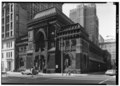 | 5,000 × 3,606 (17.2 MB) | Fæ | GWToolset: Creating mediafile for Fæ. HABS 2014-08-01 2601-2900 missing |
File usage
The following pages on the English Wikipedia use this file (pages on other projects are not listed):
Global file usage
The following other wikis use this file:
- Usage on ar.wikipedia.org
- Usage on ko.wikipedia.org