
File:Karte-Stadtteile-Wilhelmshaven.png

Size of this preview: 472 × 599 pixels. Other resolutions: 189 × 240 pixels | 378 × 480 pixels | 605 × 768 pixels | 807 × 1,024 pixels | 1,418 × 1,800 pixels.
Original file (1,418 × 1,800 pixels, file size: 618 KB, MIME type: image/png)
| This is a file from the Wikimedia Commons. Information from its description page there is shown below. Commons is a freely licensed media file repository. You can help. |
| Description |
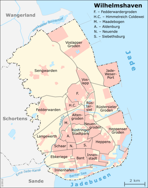
English: Map of Wilhelmshaven's city districts Deutsch: Karte der Wilhelmshavener Stadtteile
This map was created from OpenStreetMap project data, collected by the community.This map may be incomplete, and may contain errors. Don't rely solely on it for navigation. |
| Date | Unknown date |
| Source |
Deutsch: Eigene Arbeit, basierend auf English: Own work, based on
|
| Author | Muns |
| Permission (Reusing this file) |
OpenStreetMap data and maps are Creative Commons "CC-BY-SA 2.0" licensed This file is licensed under the Creative Commons Attribution-Share Alike 2.0 Generic license.
|
| Other versions | see Category:Districts of Wilhelmshaven |

|
This map has been made or improved in the German Kartenwerkstatt (Map Lab). You can propose maps to improve as well.
|
File history
Click on a date/time to view the file as it appeared at that time.
| Date/Time | Thumbnail | Dimensions | User | Comment | |
|---|---|---|---|---|---|
| current | 20:46, 21 February 2012 | | 1,418 × 1,800 (618 KB) | Muns | kartografischer Kleinkram, Industriefläche korr. --> vgl. Diskussion in der Kartenwerkstatt |
| 20:46, 21 February 2012 |  | 1,418 × 1,800 (618 KB) | Muns | kartografischer Kleinkram, Industriefläche korr. --> vgl. Diskussion in der Kartenwerkstatt | |
| 23:53, 18 February 2012 |  | 1,418 × 1,800 (627 KB) | Muns | |Description={{en|1=Map of Wilhelmshaven's city districts}} {{de|1=Karte der Wilhelmshavener Stadtteile}} This map was created from OpenStreetMap project data, collected by the community.<br/><small>This map may be incomplete, and may contain errors |
File usage
The following pages on the English Wikipedia use this file (pages on other projects are not listed):
Global file usage
The following other wikis use this file:
- Usage on de.wikipedia.org
- Usage on et.wikipedia.org
- Usage on it.wikipedia.org
- Usage on mk.wikipedia.org
- Usage on nl.wikipedia.org
- Usage on pl.wikipedia.org