
File:NJ 162 old bridge.jpg
Original file (933 × 930 pixels, file size: 176 KB, MIME type: image/jpeg)
| This is a file from the Wikimedia Commons. Information from its description page there is shown below. Commons is a freely licensed media file repository. You can help. |
This file is a work of a U.S. Army soldier or employee, taken or made as part of that person's official duties. As a work of the U.S. federal government, it is in the public domain in the United States.
|
 |
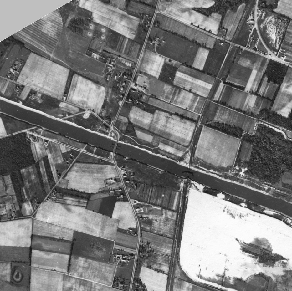
1944 aerial photo of the area of the Cape May Canal where Route 162 now crosses. Cropped and rotated 30 degrees from this image. See also Image:SR map Cape May.svg.
Source
(copied from [1])
New Jersey Shore - 1944
Location: Atlantic shore of New Jersey from Cape May to Normandy Beach.
Approx geographic coverage: South: 38.93 deg. N, 74.98 deg. W North: 39.98 deg. N, 74.07 deg. W
Photograph date: 30 and 31 October 1944.
Abstract: These are historical black and white aerial photographs of the Atlantic coast of New Jersey. Photograph dates are 30 and 31 October 1944 based on labels on some of the frames. Source of original images: photographic archives of the Beach Erosion Board (predecessor of the former Coastal Engineering Research Center), presently stored at the Coastal and Hydraulics Laboratory, Engineer Research and Development Center, in Vicksburg, Mississippi, USA. Original image condition: excellent. Printed on single-weight glossy paper. The printing date is unknown but believed to be 1944.
Aerial flight service: Flight A, 16th Photo Squadron, US Army.
Source of original images: Photographic archives of the Beach Erosion Board (predecessor of the former Coastal Engineering Research Center), presently stored at the Coastal and Hydraulics Laboratory, Engineer Research and Development Center, in Vicksburg, Mississippi, USA.
Original image condition: Excellent. Printed on single-weight glossy paper. The printing date is unknown but believed to be 1944.
Supplemental Information: Total flight lines: 3. Total number of frames is 104. These files have not been orthorectified or projected. Lens cone 8.25 inch, altitude: 13,750 ft. time: shown on every 5th or 6th frame. Label on first frame of series at Cape May: 16PS-4M777-IV43-10:31:1400-8.25:13,750-3856N7459W-Atlantic Coast Line, N.J., MD., & Del. Identification label shows: Project 777, Atlantic Coast Line, NJ, MD, & Del. 30 thru 31 Oct 44. flown by Flight A 16th Photo Squadron.
Disposition of original negatives: Unknown
Alternates sets of prints: None known
SCANNING INFORMATION:
Scanner: UMAX PowerLook 2100XL Software: MagicScan v4.5. Contrast and gain were adjusted for most frames to emphasize beach features and preserve texture in wetlands. Resolution: 600 x 600 dpi for TIFF files (not on the site); 600 x 600 dpi, 8 bit Grayscale for JPEG files. Scanning date: June and July 2005. Scanned by: Mr. Doyle Jones
FOR MORE INFORMATION:
Andrew Morang, Ph.D. Coastal and Hydraulics Laboratory, HN-CE Engineer Research and Development Center 3909 Halls Ferry Road Vicksburg, MS 39180-5002 USA
Tel voice: 601-634-2064 Facsimile: 601-634-3080
Email: [email protected]
File history
Click on a date/time to view the file as it appeared at that time.
| Date/Time | Thumbnail | Dimensions | User | Comment | |
|---|---|---|---|---|---|
| current | 02:30, 5 December 2005 | | 933 × 930 (176 KB) | SPUI~commonswiki | {{PD-USGov}} 1944 aerial photo of the area of the Cape May Canal where Route 162 now crosses. ==Source== (copied from [http://chl.wes.army.mil/shore/newjersey/shore1944/]) New Jersey Shore - 1944 Location: Atlantic shore of New Jersey from Cape May to |