
File:North Country Trail Locator Map US.svg

Size of this PNG preview of this SVG file: 800 × 417 pixels. Other resolutions: 320 × 167 pixels | 640 × 333 pixels | 1,024 × 533 pixels | 1,280 × 667 pixels | 2,560 × 1,333 pixels | 1,859 × 968 pixels.
Original file (SVG file, nominally 1,859 × 968 pixels, file size: 691 KB)
| This is a file from the Wikimedia Commons. Information from its description page there is shown below. Commons is a freely licensed media file repository. You can help. |
| Description |
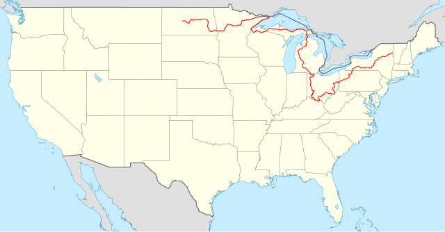
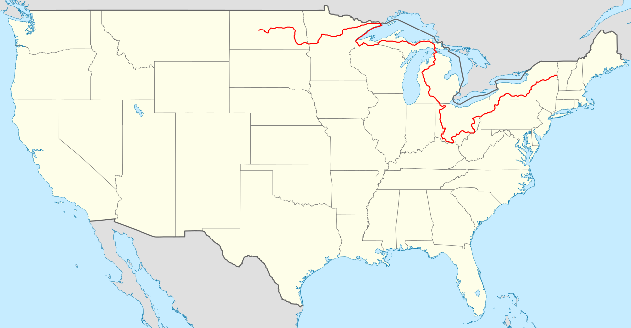
Locator map of the United States ("lower 48") with the North Country Trail overlayed. Equirectangular projection, N/S stretching 120 %. Geographic limits of the map:
|
| Date | (UTC) |
| Source |
|
| Author |
|
This file is licensed under the Creative Commons Attribution-Share Alike 3.0 Unported license.
- You are free:
- to share – to copy, distribute and transmit the work
- to remix – to adapt the work
- Under the following conditions:
- attribution – You must give appropriate credit, provide a link to the license, and indicate if changes were made. You may do so in any reasonable manner, but not in any way that suggests the licensor endorses you or your use.
- share alike – If you remix, transform, or build upon the material, you must distribute your contributions under the same or compatible license as the original.
Original upload log
This image is a derivative work of the following image:
- File:USA_location_map.svg licensed with Cc-by-sa-3.0, GFDL
- 2008-07-29T20:04:42Z NordNordWest 1859x968 (738148 Bytes) {{Information |Description= {{de|Positionskarte der [[:de:Vereinigte Staaten|Vereinigten Staaten]]}} Quadratische Plattkarte, N-S-Streckung 120 %. Geographische Begrenzung der Karte: * N: 49.8° N * S: 24.2° N * W: 125.5° W
Uploaded with derivativeFX
File history
Click on a date/time to view the file as it appeared at that time.
| Date/Time | Thumbnail | Dimensions | User | Comment | |
|---|---|---|---|---|---|
| current | 20:01, 30 December 2023 | | 1,859 × 968 (691 KB) | Bamyers99 | Removed segment in Minnesota |
| 03:54, 9 February 2011 |  | 1,859 × 968 (678 KB) | Bamyers99 | {{Information |Description=Locator map of the United States ("lower 48") with the North Country Trail overlayed. Equirectangular projection, N/S stretching 120 %. Geographic limits of the map: * N: 49.8° |
File usage
The following pages on the English Wikipedia use this file (pages on other projects are not listed):
Global file usage
The following other wikis use this file:
- Usage on de.wikipedia.org
- Usage on fr.wikipedia.org
- Usage on it.wikipedia.org
- Usage on www.wikidata.org
- Usage on zh.wikipedia.org